Skip to content

Chestnut Cove Overlook

National Park Service
Looking south-east from Chestnut Cove Overlook. Terrain and imagery at true elevation.

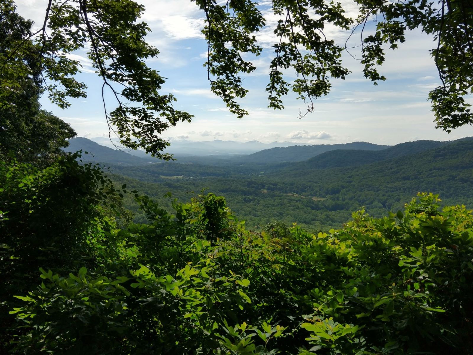
Chestnut Cove Overlook sits at 3,028 feet on the Blue Ridge Parkway, facing 120° with a drop of 558 feet within 600 meters of the pullout. The view looks east-southeast toward West Knob, Ball Mountain, Chestnut Top, Britton Mountain, Frady Mountain, and Blake Mountain, ranging from 1.7 to 6.6 miles out. The forest canopy here mixes mature pines and hardwoods with a large red maple, and the hillside below carries mountain laurel, blueberry, blackberry, sassafras, sumac, wildflowers, and American chestnut sprouts. This vegetation supports bird activity, including eastern towhee, black-throated green warbler, indigo bunting, tufted titmouse, red-eyed vireo, and Carolina chickadee, particularly in summer. The overlook faces toward sunrise, with sunrise times ranging from about 06:16 at the June solstice to 07:37 at the December solstice. Asheville is 10.5 miles north-northeast and Hendersonville is 13.9 miles southeast. Access to the Mountains-to-Sea Trail is located across the Parkway from the overlook. Bad Fork Valley Overlook precedes this stop, and View Chesnut Cove follows it.

Access
On the byway
Elevation
3,028 ft
View
Southeast · 120°
Light
Best at sunrise
Relief
558 ft drop
In view
6 named features
View from Chestnut Cove Overlook
NPS Photo / Laura White · Public domain (NPS) · NPS
Rising to an elevation of 5,721 feet (1,744 meters), Mount Pisgah is a prominent mountain near Asheville, North Carolina. The mountain was acquired by the Vanderbilt family in the late 19th Century and was sold to the United States Federal Government in 1914-1916, creating the Pisgah National Forest
w_lemay · CC BY-SA 2.0 · source
Rising to an elevation of 5,721 feet (1,744 meters), Mount Pisgah is a prominent mountain near Asheville, North Carolina. The mountain was acquired by the Vanderbilt family in the late 19th Century, and was sold to the United States Federal Government in 1914-1916, creating the Pisgah National Fores
w_lemay · CC BY-SA 2.0 · source
Rising to an elevation of 5,721 feet (1,744 meters), Mount Pisgah is a prominent mountain near Asheville, North Carolina. The mountain was acquired by the Vanderbilt family in the late 19th Century, and was sold to the United States Federal Government in 1914-1916, creating the Pisgah National Fores
w_lemay · CC BY-SA 2.0 · source
Built in 1896, the Rustic-style Buck Spring Lodge was designed by Richard Howland Hunt, son of Richard Morris Hunt, for George Vanderbilt, and his wife, Edith Stuyvesant Vanderbilt, to serve as a summer hunting lodge. The lodge was built of chestnut logs with a rough-hewn stone foundation, and was a
w_lemay · CC BY-SA 2.0 · source
Built in 1896, the Rustic-style Buck Spring Lodge was designed by Richard Howland Hunt, son of Richard Morris Hunt, for George Vanderbilt, and his wife, Edith Stuyvesant Vanderbilt, to serve as a summer hunting lodge. The lodge was built of chestnut logs with a rough-hewn stone foundation, and was a
w_lemay · CC BY-SA 2.0 · source

What you’re looking at

Named terrain inside the view from this overlook, nearest first.

  • West Knob3,271 ftsoutheast · 1.7 mi
  • Ball Mountain3,065 fteast-northeast · 2.4 mi
  • Chestnut Top3,067 fteast-southeast · 3.0 mi
  • Britton Mountain2,515 fteast · 3.9 mi
  • Frady Mountain2,518 fteast-northeast · 6.3 mi
  • Blake Mountain2,496 fteast-northeast · 6.6 mi

Light

This overlook faces sunrise 30° off square to it.

DateSunriseSunsetGolden hour
March equinox07:3519:4319:09
June solstice06:1620:5020:12
September equinox07:1919:2918:55
December solstice07:3717:2216:43

Local time (America/New_York). Computed for this exact position.

Where it is

  • Asheville10.5 mi north-northeast
  • Hendersonville13.9 mi southeast
  • Greer42.8 mi south-southeast
Loading map…
Private beta · Free to join

Take the scenic way to Chestnut Cove Overlook.

Byway plans around your taste, verified places, real weather and opening hours — then opens every leg in Google Maps with one tap.

Private beta · Free to join · No card · Invite when a spot opens

Chestnut Cove Overlook · National Park Service

This overlook was named for the trees that made up about 25% of the historic Blue Ridge forest landscape. Sadly, a fungal blight wiped out the majestic, mature American chestnut trees by the end of the 1930’s. Chestnut Cove Overlook offers a mix of mature pines and mixed hardwoods in the forest canopy with one massive red maple tree at center stage. A variety of tall shrubs, vines, and small trees are growing down the hillside, including mountain laurel, blueberry, blackberry, sassafras, sumac, wildflowers, and hardwood sprouts (including American chestnut). This rich mix of vegetative cover makes it great wildlife habitat, especially for birds. Look and listen for eastern towhee, black-throated green warblers, indigo buntings, tufted titmouse, red-eyed vireo, and Carolina chickadee. A large variety of birds can be evident at this overlook (especially in summer) due to the mature trees, the mixed shrub layer, and the edge where the two habitats come together. Berries, nuts, and fruits from these plants are also valuable to small and large mammals. The view is east across the French Broad River Valley. Ball Mountain can be seen in the foreground with Little Pisgah, Bearwallow, Bank, High Top, and Couch Mountains visible in the distance on a clear day. Access to the Mountains-to-Sea Trail is across the Parkway from the overlook. Check the conditions of the area before you visit.

Read it at National Park Service

How high is Chestnut Cove Overlook?

Chestnut Cove Overlook sits at about 3,028 feet (923 m).

What can you see from Chestnut Cove Overlook?

From Chestnut Cove Overlook: West Knob (SE, 1.7 mi); Ball Mountain (ENE, 2.4 mi); Chestnut Top (ESE, 3.0 mi); Britton Mountain (E, 3.9 mi).

Is Chestnut Cove Overlook better at sunrise or sunset?

Sunrise. The land falls away from Chestnut Cove Overlook toward the sunrise, so at sunset the light is behind you. Exact times shift through the year; the page shows the current window.

What is the nearest town to Chestnut Cove Overlook?

Asheville, 11 miles NNE of Chestnut Cove Overlook.

What is the next lookout after Chestnut Cove Overlook?

View Chesnut Cove is the next surfaced lookout along the same route after Chestnut Cove Overlook.

Drive to Chestnut Cove Overlook with Byway

Byway plans the scenic way there — real places along Blue Ridge Parkway, real weather, zero hallucinations — and hands the turns to the navigation you already use.

Byways with this lookout

Day trips start here

Locals make it Verified.

Chestnut Cove Overlook — confirmed, rated, and photographed by people who actually pulled over. A local confirmation is what upgrades a lookout from Discovered to Verified. Zero hallucinations.

Confirmed by locals

No local confirmations yet. Stood here? Yours is the one that upgrades this lookout to Verified.

Ratings

No ratings yet. Stood at this lookout? Be the first to rate it.

No written reviews yet.

Field notes

No field notes yet. Know the gate hours or the best pull-in? Leave the note you wish you'd had.

Photos

No photos yet.

Sign in to confirm this lookout, rate it, add photos, and leave field notes.

More lookouts on Blue Ridge Parkway

Named places near this lookout