Skip to content

Cumberland Gap Pinnacle Overlook

National Park Service
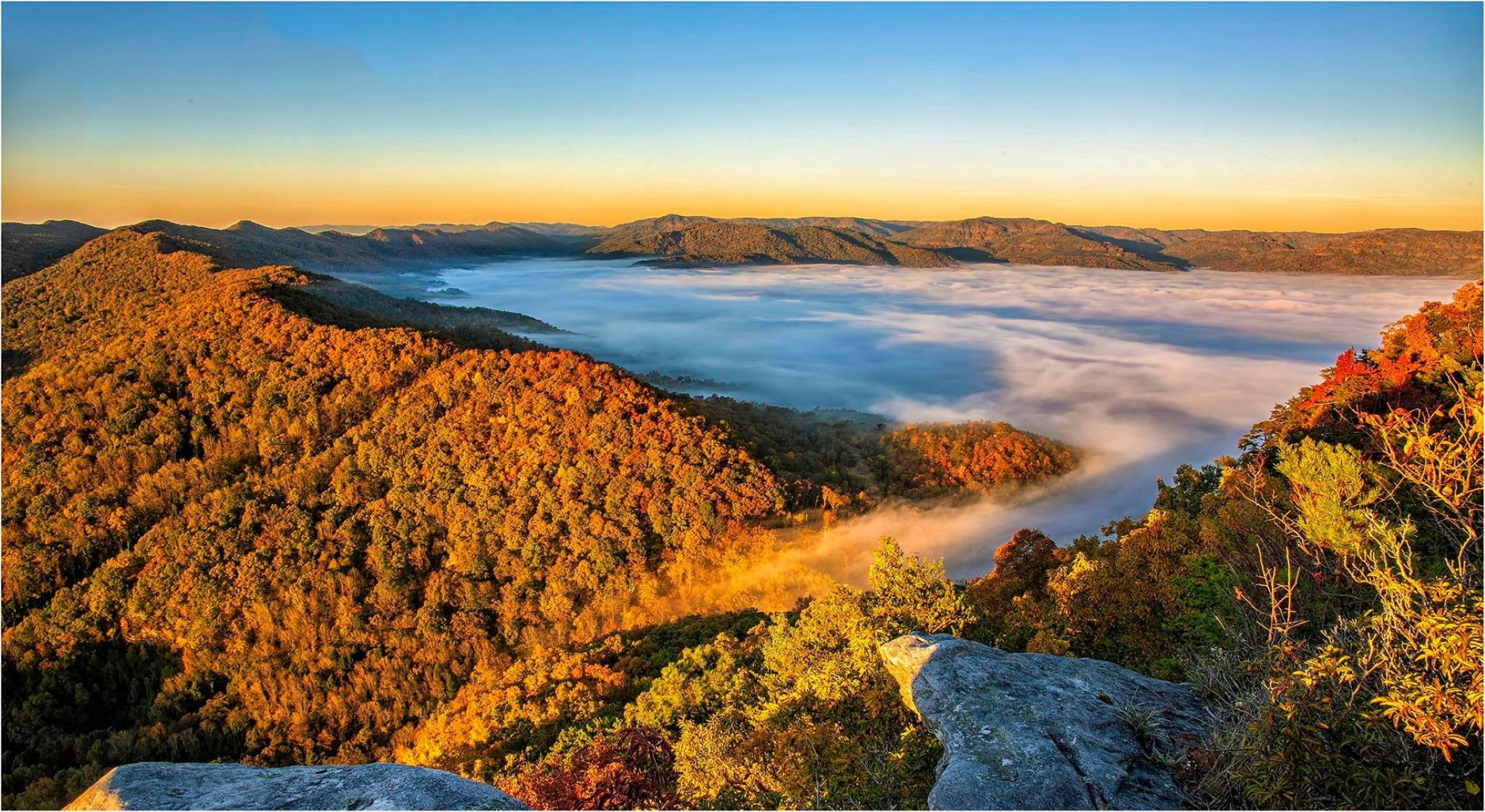
Looking south from Cumberland Gap Pinnacle Overlook. Terrain at true elevation.

Cumberland Gap Pinnacle Overlook sits at 2,329 feet along the Wilderness Road Heritage Highway, facing south across terrain that drops just over 1,000 feet within 600 meters. The parking area is in Kentucky, and the short walk to the overlook crosses into Virginia. Middlesboro lies 2.6 miles to the west. Looking south-southeast, the view takes in the Harrogate Little League fields, soccer fields, and Harrogate City Park, all under 3 miles distant and near 1,258-1,259 feet elevation. Butchers Spring appears to the south at 3.3 miles. Powell Mountain rises to the southwest at 3.9 miles, reaching 2,393 feet, while Gobblers Knob sits south-southeast at 4.2 miles and 1,625 feet, and Cline Knob extends south at 7.0 miles, 1,845 feet. Morristown lies 34.1 miles southeast and Halls is 38.9 miles south-southwest. Sunrise and sunset shift across the seasons: around 6:17 and 20:57 at the June solstice, versus 7:44 and 17:23 in December, with the equinoxes falling near 7:30 and 7:39 for sunrise and 19:33 to 19:47 for sunset.

Access
0.7 mi detour
Elevation
2,329 ft
View
South · 180°
Relief
1,004 ft drop
In view
7 named features
Pinnacle Overlook
NPS · Public domain (NPS) · NPS
The historic Cumberland Gap is a mountain pass at the border of Kentucky, Virginia, and Tennessee through which the Wilderness Road, utilized by early settlers of Kentucky, passed through on its way west from Virginia and Tennessee. The Cumberland Gap vicinity today is known as Cumberland Gap Nation
w_lemay · CC BY-SA 2.0 · source
The historic Cumberland Gap is a mountain pass at the border of Kentucky, Virginia, and Tennessee through which the Wilderness Road, utilized by early settlers of Kentucky, passed through on its way west from Virginia and Tennessee. The Cumberland Gap vicinity today is known as Cumberland Gap Nation
w_lemay · CC BY-SA 2.0 · source
The historic Cumberland Gap is a mountain pass at the border of Kentucky, Virginia, and Tennessee through which the Wilderness Road, utilized by early settlers of Kentucky, passed through on its way west from Virginia and Tennessee. The Cumberland Gap vicinity today is known as Cumberland Gap Nation
w_lemay · CC BY-SA 2.0 · source
The historic Cumberland Gap is a mountain pass at the border of Kentucky, Virginia, and Tennessee through which the Wilderness Road, utilized by early settlers of Kentucky, passed through on its way west from Virginia and Tennessee. The Cumberland Gap vicinity today is known as Cumberland Gap Nation
w_lemay · CC BY-SA 2.0 · source
The historic Cumberland Gap is a mountain pass at the border of Kentucky, Virginia, and Tennessee through which the Wilderness Road, utilized by early settlers of Kentucky, passed through on its way west from Virginia and Tennessee. The Cumberland Gap vicinity today is known as Cumberland Gap Nation
w_lemay · CC BY-SA 2.0 · source

What you’re looking at

Named terrain inside the view from this overlook, nearest first.

  • Harrogate Little League1,258 ftsouth-southeast · 2.1 mi
  • Soccer Fields1,259 ftsouth-southeast · 2.5 mi
  • Harrogate City Park1,258 ftsouth-southeast · 2.7 mi
  • Butchers Spring1,291 ftsouth · 3.3 mi
  • Powell Mountain2,393 ftsouthwest · 3.9 mi
  • Gobblers Knob1,625 ftsouth-southeast · 4.2 mi
  • Cline Knob1,845 ftsouth · 7.0 mi

Light

DateSunriseSunsetGolden hour
March equinox07:3919:4719:13
June solstice06:1720:5720:19
September equinox07:2319:3318:59
December solstice07:4417:2316:43

Local time (America/New_York). Computed for this exact position.

Where it is

  • Middlesboro2.6 mi west
  • Morristown34.1 mi southeast
  • Halls38.9 mi south-southwest
Loading map…
Private beta · Free to join

Take the scenic way to Cumberland Gap Pinnacle Overlook.

Byway plans around your taste, verified places, real weather and opening hours — then opens every leg in Google Maps with one tap.

Private beta · Free to join · No card · Invite when a spot opens

Cumberland Gap Pinnacle Overlook · National Park Service

A short drive from the main visitor center in Middlesboro, Ky lies this scenic overlook. As you approach the Pinnacle from the parking lot, you park in Kentucky and walk into Virginia before reaching the overlook. Known as the Pinnacle, locals have used that name for generations, dating back to the early 1800s.The Pinnacle saw bison pass through the valley below through the Cumberland Gap. It was a place where thousands of people passed by on their way through the Gap. First, Native Americans like the Cherokee and Shawnee used the gap to journey to hunting grounds, build new settlements, trade, and war. Later, colonists went through the Gap heading west to build a new life. The Pinnacle was also crucial during the civil war. Fortifcations lined the mountain not far from this peak with cannons pointing at the valley below the mountain. According to legend, Confederate soldiers tossed their cannons into the valley before retreating to the south. While the Pinnacle has much history, many visitors come to see it today for its scenic views. Looking to the right or west, one will see the town of Middlesboro, Kentucky. Middlesboro lies in the center of a crater, created by meteor crashing into spot millions of years ago. If one follows the path to the left of Middlesboro, you will see the Cumberland Gap, the pass through the mountain that leads into the town of Cumberland Gap, Tennessee.To the south of the town, one can see a road leading to the tunnel that cuts through the mountain. Not far to south of the tunnel, one observes Harrogate, Tennesee and Lincoln Memorial University. Founded in the 1890s, the University is dedicated to the memory of Abraham Lincoln. East of Harrogate, continues into Tennessee and finally at the far left is Virginia. On clear days you may see the mountains of Tennessee, including Powell, Clinch, and Bays. Sometimes you can see the far edges of the Smokey Mountains in North Carolina to the south east

Read it at National Park Service →

How high is Cumberland Gap Pinnacle Overlook?

Cumberland Gap Pinnacle Overlook sits at about 2,329 feet (710 m).

What can you see from Cumberland Gap Pinnacle Overlook?

From Cumberland Gap Pinnacle Overlook: Harrogate Little League (SSE, 2.1 mi); Soccer Fields (SSE, 2.5 mi); Harrogate City Park (SSE, 2.7 mi); Butchers Spring (S, 3.3 mi).

What is the nearest town to Cumberland Gap Pinnacle Overlook?

Middlesboro, 2.6 miles W of Cumberland Gap Pinnacle Overlook.

Drive to Cumberland Gap Pinnacle Overlook with Byway

Byway plans the scenic way there — real places along Wilderness Road Heritage Highway, real weather, zero hallucinations — and hands the turns to the navigation you already use.

Byways with this lookout

Locals make it Verified.

Cumberland Gap Pinnacle Overlook — confirmed, rated, and photographed by people who actually pulled over. A local confirmation is what upgrades a lookout from Discovered to Verified. Zero hallucinations.

Confirmed by locals

No local confirmations yet. Stood here? Yours is the one that upgrades this lookout to Verified.

Ratings

No ratings yet. Stood at this lookout? Be the first to rate it.

No written reviews yet.

Field notes

No field notes yet. Know the gate hours or the best pull-in? Leave the note you wish you'd had.

Photos

No photos yet.

Sign in to confirm this lookout, rate it, add photos, and leave field notes.

More lookouts on Wilderness Road Heritage Highway

Named places near this lookout