Skip to content

Diablo Lake Overlook

VerifiedOpenStreetMap + National Park Service
Looking north-west from Diablo Lake Overlook. Terrain and imagery at true elevation.

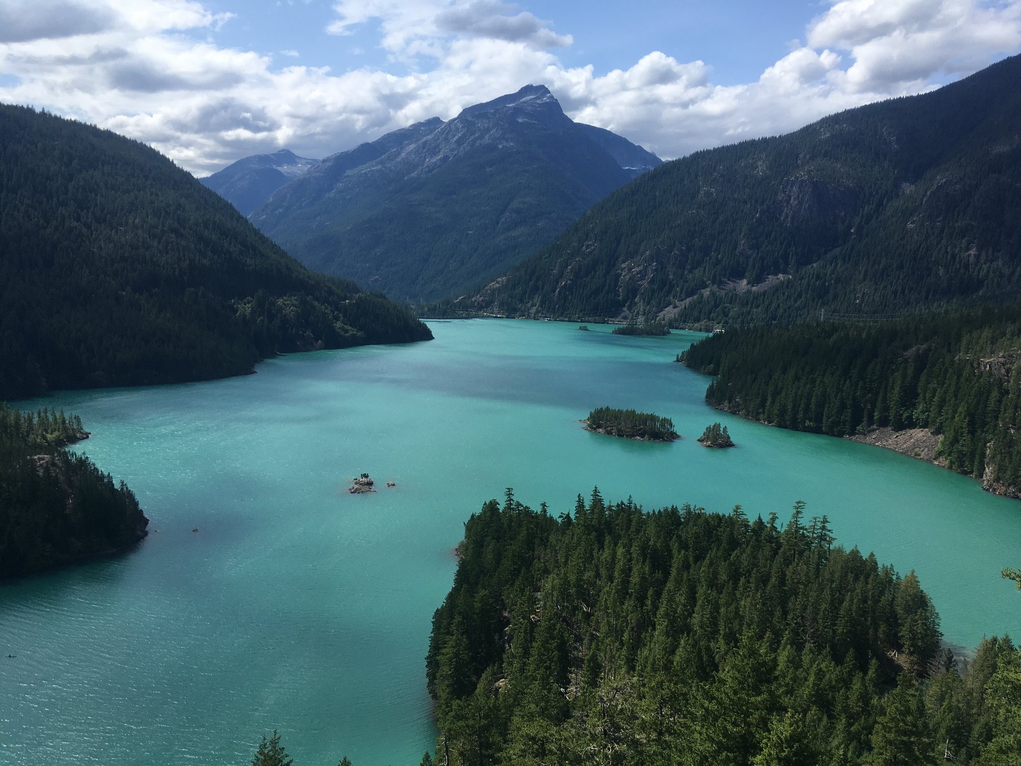
Diablo Lake Overlook sits at 1,672 feet along the byway between the Keystone Ferry zone on Whidbey Island and SR 153 near Twisp, facing 300 degrees toward glacial-fed Diablo Lake and Diablo Dam. The terrain drops 463 feet within 600 meters of the overlook, giving an open view down toward the lake and the rugged mountains around it. Visible peaks include Davis Peak to the west-northwest at 5.0 miles (7,003 ft), Mount Ross to the west at 6.7 miles (6,030 ft), Inspiration Peak to the west-northwest at 9.6 miles (7,833 ft), and Mount Degenhardt to the west-northwest at 10.0 miles (8,020 ft). In summer, the lake takes on a turquoise color caused by glacial flour, fine rock particles carried into the water by glacial streams, with the color most pronounced on sunny days in July, August, and September. The overlook faces toward the sunset, roughly 30 degrees off square, with sunset times ranging from about 16:11 in December to 21:12 in June. Concrete lies 31.9 miles west-southwest, and Darrington is 39.2 miles southwest. Visitors are asked not to feed wildlife or leave food and waste unattended.

Access
On the byway
Elevation
1,672 ft
View
Northwest · 300°
Light
Best at sunset
Relief
463 ft drop
In view
4 named features
Diablo Lake Overlook
NPS / M. Bluestein · Public domain (NPS) · NPS
Diablo Lake, Washington state, USA. View from Diablo Lake Overlook.
Steven Pavlov · CC BY-SA 3.0 · source
Diablo Lake Overlook
Steven Pavlov · CC BY-SA 4.0 · source
Diablo Lake in Washington state , USA, with Davis Peak in the background.
Bob Collowan · CC BY-SA 3.0 · source
Diablo Lake, WA
Dieter F · CC BY-SA 3.0 · source
Clouds rolling over North Cascades near Diablo Lake
Robert Ashworth from Bellingham, WA., USA · CC BY 2.0 · source

What you’re looking at

Named terrain inside the view from this overlook, nearest first.

  • Davis Peak7,003 ftwest-northwest · 5.0 mi
  • Mount Ross6,030 ftwest · 6.7 mi
  • Inspiration Peak7,833 ftwest-northwest · 9.6 mi
  • Mount Degenhardt8,020 ftwest-northwest · 10.0 mi

Light

This overlook faces sunset 30° off square to it.

DateSunriseSunsetGolden hour
March equinox07:0819:1718:36
June solstice05:0221:1220:22
September equinox06:5219:0418:23
December solstice07:5516:1115:16

Local time (America/Los_Angeles). Computed for this exact position.

Where it is

  • Concrete31.9 mi west-southwest
  • Darrington39.2 mi southwest
Loading map…
Private beta · Free to join

Take the scenic way to Diablo Lake Overlook.

Byway plans around your taste, verified places, real weather and opening hours — then opens every leg in Google Maps with one tap.

Private beta · Free to join · No card · Invite when a spot opens

Diablo Lake Overlook · National Park Service

Enjoy views of glacial-fed Diablo Lake, located within the heart of North Cascades. See rugged mountains that rise around the lake and the historic Diablo Dam in the distance. Learn about water, geology, glaciers, and the plants and animals that call this place home. Do not feed the wildlife or leave food and waste unattended. In summer, the distinctive turquoise color of the lake is the result of suspended fine rock particles refracting sunlight. These rock particles, called glacial flour, enter the lake when rock from the surrounding mountains is eroded by ice and flows into the water through glacial streams. The color is most vibrant on sunny days in July, August, and September when seasonal glacial melt occurs.

Read it at National Park Service

Mount Ross · WikipediaCC BY-SA

Mount Ross is a 6,052-foot (1,845 m) mountain summit located in the North Cascades, in Whatcom County, Washington, United States.

Read it at Wikipedia

How high is Diablo Lake Overlook?

Diablo Lake Overlook sits at about 1,672 feet (510 m).

What can you see from Diablo Lake Overlook?

From Diablo Lake Overlook: Davis Peak (WNW, 5.0 mi); Mount Ross (W, 6.7 mi); Inspiration Peak (WNW, 9.6 mi); Mount Degenhardt (WNW, 10.0 mi).

Is Diablo Lake Overlook better at sunrise or sunset?

Sunset. The land falls away from Diablo Lake Overlook toward the sunset, so at sunrise the light is behind you. Exact times shift through the year; the page shows the current window.

What is the nearest town to Diablo Lake Overlook?

Concrete, 32 miles WSW of Diablo Lake Overlook.

Drive to Diablo Lake Overlook with Byway

Byway plans the scenic way there — real places along Jct Keystone Ferry Zone Whidbey Island To Jct Sr 153 Vic Twisp, real weather, zero hallucinations — and hands the turns to the navigation you already use.

Byways with this lookout

Day trips start here

Locals make it Verified.

Diablo Lake Overlook — confirmed, rated, and photographed by people who actually pulled over. A local confirmation is what upgrades a lookout from Discovered to Verified. Zero hallucinations.

Confirmed by locals

No local confirmations yet. Stood here? Yours is the one that upgrades this lookout to Verified.

Ratings

No ratings yet. Stood at this lookout? Be the first to rate it.

No written reviews yet.

Field notes

No field notes yet. Know the gate hours or the best pull-in? Leave the note you wish you'd had.

Photos

No photos yet.

Sign in to confirm this lookout, rate it, add photos, and leave field notes.

More lookouts on Jct Keystone Ferry Zone Whidbey Island To Jct Sr 153 Vic Twisp

Named places near this lookout