Skip to content

Elwha Dam Overlook Trailhead

National Park Service
Looking north from Elwha Dam Overlook Trailhead. Terrain and imagery at true elevation.

Elwha Dam Overlook Trailhead sits at 338 ft elevation along the Boundary Of Makah Indian Res To Vic Lairds Corner byway, with the land dropping 212 ft within 600 meters of the site. A short hike from the Elwha River Restoration Interpretive Center leads to the site of one of the former dams, where the changes to the river valley from the ongoing restoration process can be seen. Foliage may obscure the dam site depending on the time of year. Billy Whiteshoes Memorial Park lies to the north, 3.1 miles away at 20 ft elevation. Port Angeles is 5.8 miles to the east-northeast, Sequim is 20.5 miles east, and Port Townsend is 36.2 miles east. Pillar Point is the previous lookout along the byway. Sunrise and sunset times vary through the year: near the March equinox, sunrise is at 07:18 and sunset at 19:27; at the June solstice, sunrise is at 05:15 and sunset at 21:19; near the September equinox, sunrise is at 07:02 and sunset at 19:14; and at the December solstice, sunrise is at 08:03 and sunset at 16:24.

Access
On the byway
Elevation
338 ft
View
North · 0°
Relief
212 ft drop
In view
1 named features
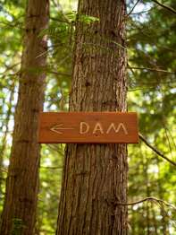
A small wooden sign on a tree reads "DAM" with an arrow.
National Park Service · Public domain (NPS) · NPS
Elwha River Bridge, SR-101 Elwha
Staxilicious · CC BY-SA 3.0 · source
Lake Aldwell between trees
Manuel Velazquez · CC BY 3.0 · source
Two dams, that didn't generate that much hydroelectric power anyway, have been removed. Since most of the Elwa River runs through "wild and free" Olympic National Park, the only impediments to a wild river were the two dams on the lower Elwa. Dams have been removed to restore the river for salmon an
Robert Ashworth from Bellingham, WA., USA · CC BY 2.0 · source
Part of the river's restoration is cleaning out metalic junk and rebar in the area
Robert Ashworth from Bellingham, WA., USA · CC BY 2.0 · source
I saw some of the area around the lower dam, but the upper dam area was not accessible due to a road washout. From what I gather, there is a section of the upper dam remaining as an observation platform. That dam was called Glines Canyon Dam.
Robert Ashworth from Bellingham, WA., USA · CC BY 2.0 · source

What you’re looking at

Named terrain inside the view from this overlook, nearest first.

  • Billy Whiteshoes Memorial Park20 ftnorth · 3.1 mi

Light

DateSunriseSunsetGolden hour
March equinox07:1819:2718:46
June solstice05:1521:1920:30
September equinox07:0219:1418:33
December solstice08:0316:2415:30

Local time (America/Los_Angeles). Computed for this exact position.

Where it is

  • Port Angeles5.8 mi east-northeast
  • Sequim20.5 mi east
  • Port Townsend36.2 mi east
Loading map…
Private beta · Free to join

Take the scenic way to Elwha Dam Overlook Trailhead.

Byway plans around your taste, verified places, real weather and opening hours — then opens every leg in Google Maps with one tap.

Private beta · Free to join · No card · Invite when a spot opens

Elwha Dam Overlook Trailhead · National Park Service

A short hike from the Elwha River Restoration Interpretive Center leads to the site of one of the former dams, where you can see just how much the river valley has changed in the ongoing restoration process. Depending on the time of year, foliage may make it difficult to see the site of the dam.

Read it at National Park Service

How high is Elwha Dam Overlook Trailhead?

Elwha Dam Overlook Trailhead sits at about 338 feet (103 m).

What can you see from Elwha Dam Overlook Trailhead?

From Elwha Dam Overlook Trailhead: Billy Whiteshoes Memorial Park (N, 3.1 mi).

What is the nearest town to Elwha Dam Overlook Trailhead?

Port Angeles, 5.8 miles ENE of Elwha Dam Overlook Trailhead.

Drive to Elwha Dam Overlook Trailhead with Byway

Byway plans the scenic way there — real places along Boundary Of Makah Indian Res To Vic Lairds Corner, real weather, zero hallucinations — and hands the turns to the navigation you already use.

Byways with this lookout

Day trips start here

Locals make it Verified.

Elwha Dam Overlook Trailhead — confirmed, rated, and photographed by people who actually pulled over. A local confirmation is what upgrades a lookout from Discovered to Verified. Zero hallucinations.

Confirmed by locals

No local confirmations yet. Stood here? Yours is the one that upgrades this lookout to Verified.

Ratings

No ratings yet. Stood at this lookout? Be the first to rate it.

No written reviews yet.

Field notes

No field notes yet. Know the gate hours or the best pull-in? Leave the note you wish you'd had.

Photos

No photos yet.

Sign in to confirm this lookout, rate it, add photos, and leave field notes.

More lookouts on Boundary Of Makah Indian Res To Vic Lairds Corner

Named places near this lookout