Skip to content

Horsehead Overlook

National Park Service
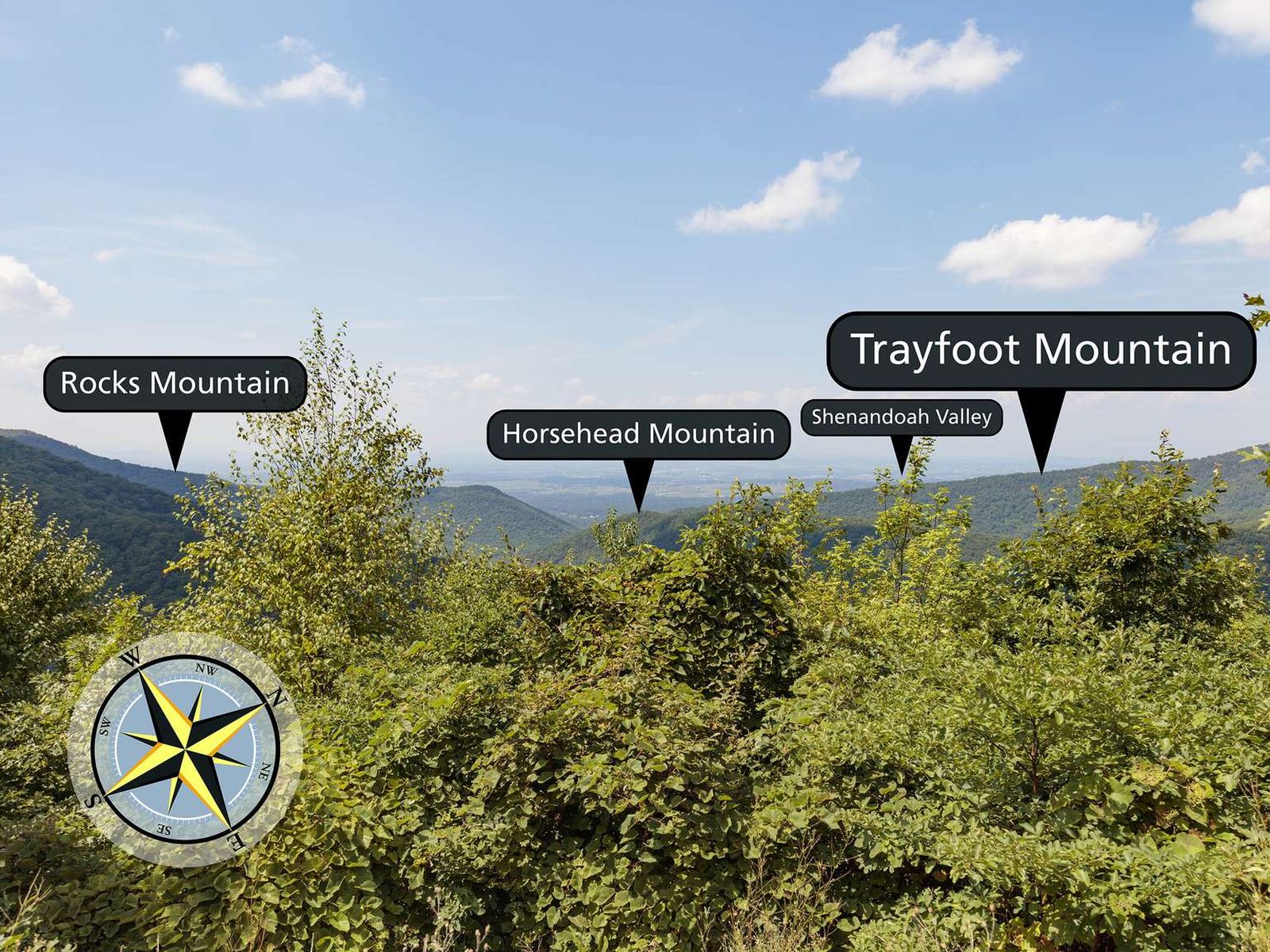
Looking west from Horsehead Overlook. Terrain at true elevation.

Horsehead Overlook sits at 2,569 feet along Skyline Drive, facing west at 270 degrees, directly toward sunset. The terrain drops 801 feet within 600 meters of the overlook, giving an open view across the land below. Three peaks are visible: Calvary Rocks to the west-southwest at 1.0 mile (2,870 ft), Horsehead Mountain to the west-northwest at 1.2 miles (2,056 ft), and Rocks Mountain to the west-southwest at 1.3 miles (2,939 ft). Because the view faces the setting sun squarely, this spot suits evening stops; sunset times range from about 16:59 at the December solstice to 20:42 at the June solstice. Staunton lies 17.4 miles west, Harrisonburg 18.7 miles north-northwest, and Charlottesville 19.0 miles southeast. The previous stop along the byway is Horsehead Mountain Overlook, and the next is Chimney Rock. According to the National Park Service, the overlook looks northwest into Augusta County in the southern Shenandoah Valley, a county formed in 1738 and named for Augusta of Saxe-Gotha, Princess of Wales and mother of the future King George III.

Access
On the byway
Elevation
2,569 ft
View
West · 270°
Light
Best at sunset
Relief
801 ft drop
In view
3 named features
A view over tall bushes to hills and valley beyond.
National Park Service · Public domain (NPS) · NPS
View south along Shenandoah National Park's Skyline Drive just south of the Horsehead Overlook in Augusta County, Virginia
Famartin · CC BY-SA 4.0 · source
View west-northwest from the Horsehead Overlook along Shenandoah National Park's Skyline Drive in Augusta County, Virginia
Famartin · CC BY-SA 4.0 · source
View north along Shenandoah National Park's Skyline Drive just north of the Horsehead Overlook in Augusta County, Virginia
Famartin · CC BY-SA 4.0 · source
Sign for the Horsehead Overlook along Shenandoah National Park's Skyline Drive in Augusta County, Virginia
Famartin · CC BY-SA 4.0 · source
View south along Shenandoah National Park's Skyline Drive just south of the Trayfoot Mountain Overlook in Albemarle County, Virginia
Famartin · CC BY-SA 4.0 · source

What you’re looking at

Named terrain inside the view from this overlook, nearest first.

  • Calvary Rocks2,870 ftwest-southwest · 1.0 mi
  • Horsehead Mountain2,056 ftwest-northwest · 1.2 mi
  • Rocks Mountain2,939 ftwest-southwest · 1.3 mi

Light

This overlook faces sunset — 0° off square to it.

DateSunriseSunsetGolden hour
March equinox07:1919:2718:52
June solstice05:5320:4220:03
September equinox07:0319:1418:39
December solstice07:2916:5916:18

Local time (America/New_York). Computed for this exact position.

Where it is

  • Staunton17.4 mi west
  • Harrisonburg18.7 mi north-northwest
  • Charlottesville19.0 mi southeast
Loading map…
Private beta · Free to join

Take the scenic way to Horsehead Overlook.

Byway plans around your taste, verified places, real weather and opening hours — then opens every leg in Google Maps with one tap.

Private beta · Free to join · No card · Invite when a spot opens

Horsehead Overlook · National Park Service

Look northwest to the Shenandoah Valley from an elevation of 2,580 ft (786 m) at Horsehead Overlook. You are looking into Augusta County in the southern Shenandoah Valley. Augusta County was formed in 1738 and named after Augusta of Saxe-Gotha, Princess of Wales and mother of future King George III.

Read it at National Park Service →

How high is Horsehead Overlook?

Horsehead Overlook sits at about 2,569 feet (783 m).

What can you see from Horsehead Overlook?

From Horsehead Overlook: Calvary Rocks (WSW, 1.0 mi); Horsehead Mountain (WNW, 1.2 mi); Rocks Mountain (WSW, 1.3 mi).

Is Horsehead Overlook better at sunrise or sunset?

Sunset. The land falls away from Horsehead Overlook toward the sunset, so at sunrise the light is behind you. Exact times shift through the year; the page shows the current window.

What is the nearest town to Horsehead Overlook?

Staunton, 17 miles W of Horsehead Overlook.

What is the next lookout after Horsehead Overlook?

Chimney Rock is the next surfaced lookout along the same route after Horsehead Overlook.

Drive to Horsehead Overlook with Byway

Byway plans the scenic way there — real places along Skyline Drive, real weather, zero hallucinations — and hands the turns to the navigation you already use.

Byways with this lookout

Day trips start here

Locals make it Verified.

Horsehead Overlook — confirmed, rated, and photographed by people who actually pulled over. A local confirmation is what upgrades a lookout from Discovered to Verified. Zero hallucinations.

Confirmed by locals

No local confirmations yet. Stood here? Yours is the one that upgrades this lookout to Verified.

Ratings

No ratings yet. Stood at this lookout? Be the first to rate it.

No written reviews yet.

Field notes

No field notes yet. Know the gate hours or the best pull-in? Leave the note you wish you'd had.

Photos

No photos yet.

Sign in to confirm this lookout, rate it, add photos, and leave field notes.

More lookouts on Skyline Drive

Named places near this lookout