Skip to content

Ivy Creek Overlook

VerifiedOpenStreetMap + National Park Service
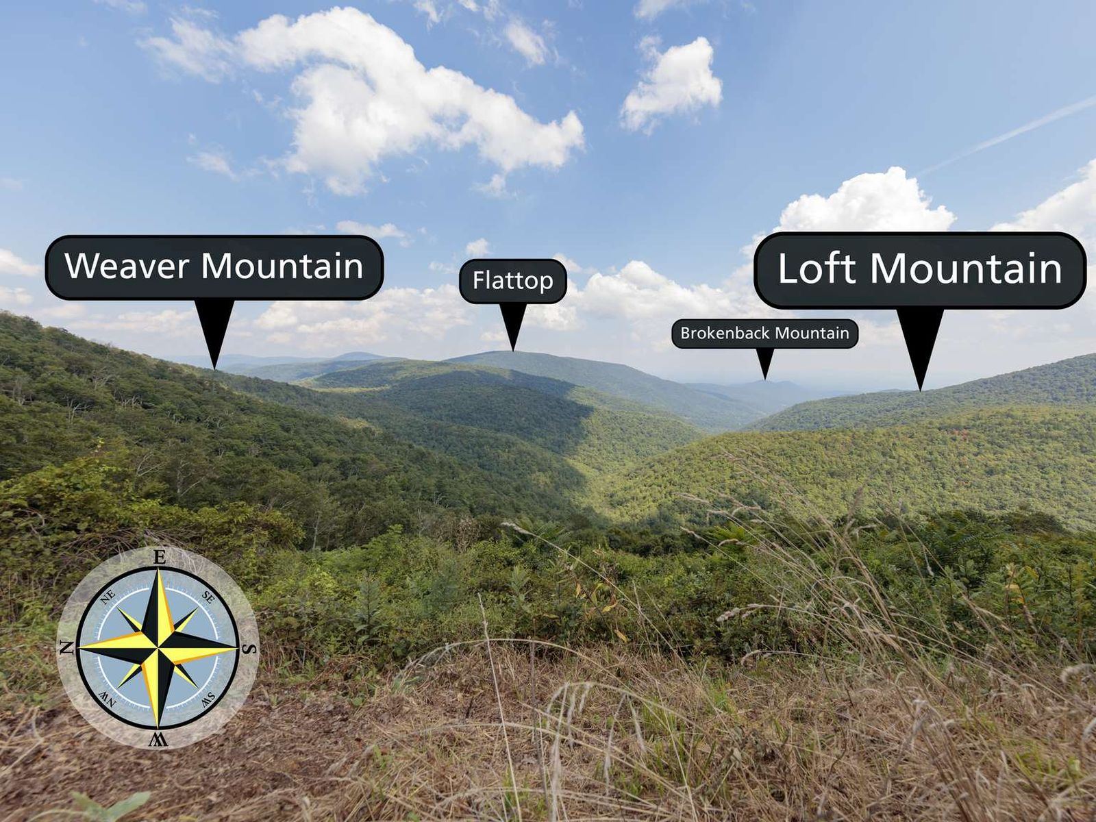
Looking east from Ivy Creek Overlook. Terrain and imagery at true elevation.

Ivy Creek Overlook sits at 2,839 feet on Skyline Drive, facing 95 degrees, with the land dropping 843 feet within 600 meters of the pulloff. The view opens onto Weaver Mountain to the east-northeast at 1.6 miles and Loft Mountain Overlook directly east at the same distance, with Flattop Mountain rising to 3,326 feet farther out to the east-northeast at 3.0 miles. Other features visible include Belfore Hollow Overlook and Eaton Hollow Overlook to the northeast, County Line Mountain to the southeast, and Roundtop and Bush Mountain farther northeast. Brokenback Mountain lies to the east-southeast at 5.8 miles. Because the overlook faces close to due east, sunrise is roughly aligned with the view; sunrise times range from about 5:52 in June to 7:29 in December. Harrisonburg is 16.1 miles to the northwest, Charlottesville is 20.2 miles south-southeast, and Staunton is 24.3 miles west-southwest. Brown Mountain Overlook precedes this stop along the drive, and Rocky Top Overlook follows it.

Access
On the byway
Elevation
2,839 ft
View
East · 95°
Light
Best at sunrise
Relief
843 ft drop
In view
9 named features
A view with grass in the foreground and mountains in the distance.
National Park Service · Public domain (NPS) · NPS
East from Ivy Creek Overlook in Shenandoah National Park, Virginia
Fredlyfish4 · CC BY-SA 4.0 · source
View northeast from the Ivy Creek Overlook along Shenandoah National Park's Skyline Drive on the border of Greene County, Virginia and Rockingham County, Virginia
Famartin · CC BY-SA 4.0 · source
View south along Shenandoah National Park's Skyline Drive just south of the Ivy Creek Overlook on the border of Greene County, Virginia and Rockingham County, Virginia
Famartin · CC BY-SA 4.0 · source
View east from the Ivy Creek Overlook along Shenandoah National Park's Skyline Drive on the border of Greene County, Virginia and Rockingham County, Virginia
Famartin · CC BY-SA 4.0 · source
View east-northeast from the Ivy Creek Overlook along Shenandoah National Park's Skyline Drive on the border of Greene County, Virginia and Rockingham County, Virginia
Famartin · CC BY-SA 4.0 · source

What you’re looking at

Named terrain inside the view from this overlook, nearest first.

  • Weaver Mountain2,855 fteast-northeast · 1.6 mi
  • Loft Mountain Overlook2,494 fteast · 1.6 mi
  • Belfore Hollow Overlook2,427 ftnortheast · 2.9 mi
  • Flattop Mountain3,326 fteast-northeast · 3.0 mi
  • County Line Mountain1,978 ftsoutheast · 3.1 mi
  • Eaton Hollow Overlook2,521 ftnortheast · 4.0 mi
  • Roundtop2,956 ftnortheast · 5.1 mi
  • Bush Mountain2,694 ftnortheast · 5.4 mi
  • Brokenback Mountain1,748 fteast-southeast · 5.8 mi

Light

This overlook faces sunrise 5° off square to it.

DateSunriseSunsetGolden hour
March equinox07:1919:2718:52
June solstice05:5220:4220:03
September equinox07:0319:1318:39
December solstice07:2916:5816:17

Local time (America/New_York). Computed for this exact position.

Where it is

  • Harrisonburg16.1 mi northwest
  • Charlottesville20.2 mi south-southeast
  • Staunton24.3 mi west-southwest
Loading map…
Private beta · Free to join

Take the scenic way to Ivy Creek Overlook.

Byway plans around your taste, verified places, real weather and opening hours — then opens every leg in Google Maps with one tap.

Private beta · Free to join · No card · Invite when a spot opens

Ivy Creek Overlook · National Park Service

Facing east from an elevation of 2,890 ft (880 m), you will look out to the rolling ridges of Shenandoah National Park from Ivy Creek Overlook. Weaver Mountain descends from the left, while Loft Mountain descends from the right. Straight ahead is Flattop Mountain. The Appalachian Trail intersects with this overlook, as well.

Maintenance of this view funded Greene County and Hugh and Temple Joyce through the Shenandoah National Park Trust Adopt an Overlook program.

Read it at National Park Service

How high is Ivy Creek Overlook?

Ivy Creek Overlook sits at about 2,839 feet (865 m).

What can you see from Ivy Creek Overlook?

From Ivy Creek Overlook: Weaver Mountain (ENE, 1.6 mi); Loft Mountain Overlook (E, 1.6 mi); Belfore Hollow Overlook (NE, 2.9 mi); Flattop Mountain (ENE, 3.0 mi).

Is Ivy Creek Overlook better at sunrise or sunset?

Sunrise. The land falls away from Ivy Creek Overlook toward the sunrise, so at sunset the light is behind you. Exact times shift through the year; the page shows the current window.

What is the nearest town to Ivy Creek Overlook?

Harrisonburg, 16 miles NW of Ivy Creek Overlook.

What is the next lookout after Ivy Creek Overlook?

Rocky Top Overlook is the next surfaced lookout along the same route after Ivy Creek Overlook.

Drive to Ivy Creek Overlook with Byway

Byway plans the scenic way there — real places along Skyline Drive, real weather, zero hallucinations — and hands the turns to the navigation you already use.

Byways with this lookout

Day trips start here

Locals make it Verified.

Ivy Creek Overlook — confirmed, rated, and photographed by people who actually pulled over. A local confirmation is what upgrades a lookout from Discovered to Verified. Zero hallucinations.

Confirmed by locals

No local confirmations yet. Stood here? Yours is the one that upgrades this lookout to Verified.

Ratings

No ratings yet. Stood at this lookout? Be the first to rate it.

No written reviews yet.

Field notes

No field notes yet. Know the gate hours or the best pull-in? Leave the note you wish you'd had.

Photos

No photos yet.

Sign in to confirm this lookout, rate it, add photos, and leave field notes.

More lookouts on Skyline Drive

Named places near this lookout