Skip to content

Mascall Formation Overlook

National Park Service
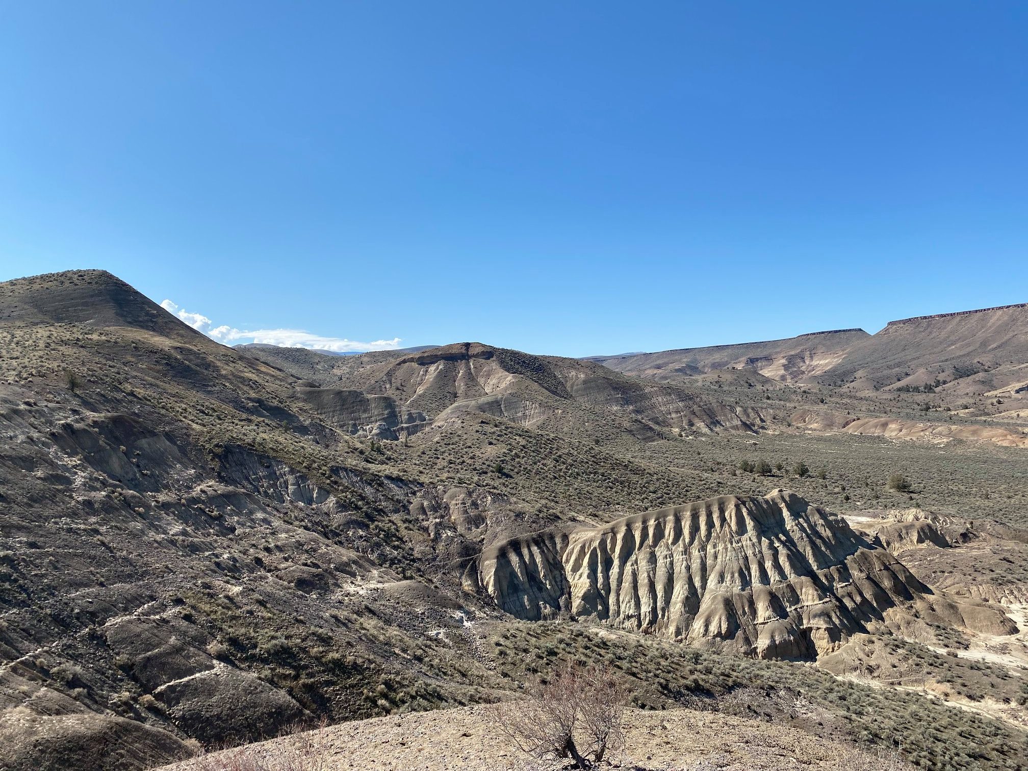
Looking north-east from Mascall Formation Overlook. Terrain and imagery at true elevation.

Mascall Formation Overlook sits at 2,493 feet along the Journey Through Time byway, at mile 114 of 277, facing roughly 30 degrees toward Picture Gorge and Sheep Rock. The ground drops 217 feet within 600 meters of the overlook. Picture Gorge is visible to the north, 1.4 miles away at 2,629 feet, and Sheep Rock is visible farther north, 3.3 miles away at 3,343 feet. The site includes informational brochures, picnic tables, and pit toilets, reached by a 430-foot round-trip walk. The overlook takes its name from the Mascall Formation, rock laid down in wide, level basins after a volcanic period 15 million years ago, with lakes and meandering streams forming atop earlier Picture Gorge Basalt flows. Layers of volcanic ash tuffs alternate with ancient soils and stream deposits, including the 15-million-year-old Mascall Tuff, near which many vertebrate fossils have been found. The previous stop on the byway is Mascall Overlook. Nearby towns include Mount Vernon, 25.7 miles east-southeast; John Day, 33.5 miles east; and Canyon City, 34.0 miles east-southeast.

Position
Mile ~114 of 277
Access
0.4 mi detour
Elevation
2,493 ft
View
Northeast · 30°
Relief
217 ft drop
In view
2 named features
Mascall Formation
NPS Photo · Public domain (NPS) · NPS
picture gorge Oregon (LJ)
james shaw · CC BY-SA 3.0 · source
Telephoto lens image of an exposure of the Rattlesnake Formation just west of Picture Gorge in central Oregon, taken from the Mascall Overlook. The caprock at the top is the ignimbrite in the middle of the formation.
Jstuby · CC0 · source
Outcrop of the Mascall Formation at the Mascall Overlook near Picture Gorge in central Oregon.
Jstuby · CC0 · source
View of Earth taken during ISS Expedition 67.
Earth Science and Remote Sensing Unit , Lyndon B. Johnson Space Center · Public domain · source
View of Earth taken during ISS Expedition 67.
Earth Science and Remote Sensing Unit , Lyndon B. Johnson Space Center · Public domain · source

What you’re looking at

Named terrain inside the view from this overlook, nearest first.

  • Picture Gorge2,629 ftnorth · 1.4 mi
  • Sheep Rock3,343 ftnorth · 3.3 mi

Light

DateSunriseSunsetGolden hour
March equinox07:0219:1118:33
June solstice05:1520:4820:03
September equinox06:4618:5818:19
December solstice07:3316:2215:34

Local time (America/Los_Angeles). Computed for this exact position.

Where it is

Mile 114 of 277 along Journey Through Time.

  • Mount Vernon25.7 mi east-southeast
  • John Day33.5 mi east
  • Canyon City34.0 mi east-southeast
Loading map…
Private beta · Free to join

Take the scenic way to Mascall Formation Overlook.

Byway plans around your taste, verified places, real weather and opening hours — then opens every leg in Google Maps with one tap.

Private beta · Free to join · No card · Invite when a spot opens

Mascall Formation Overlook · National Park Service

Mascall Formation Overlook (430 feet round trip) Sweeping views of the John Day Valley and Picture Gorge can be seen from the overlook. Informational brochures, picnic tables, and pit toilets are located here as well. Mascall Formation The rocks of the Mascall Formation were laid down in a series of wide, level basins following a ferocious volcanic period 15 million years ago. The Mascall landscape consisted of several broad basins with lakes and meandering streams that formed atop the last of the Picture Gorge Basalt flows. These deposits were subsequently covered by successive falls of ash from volcanoes to the west and from the much closer Strawberry volcanics to the east. Alternating between the tuffs (consolidated volcanic ash) are layers of ancient soils and stream deposits that provide evidence of a dynamic floodplain. Many of the vertebrate fossils from the Mascall formation are found in close association with a prominent layer, the 15 million-year-old “Mascall Tuff.”   Changing Climates Although dramatic fluctuations in the global climate and regional volcanic activity continued, there were enough phases of moderate climate with ample rainfall and fertile soil to allow the growth of lush grasses and mixed hardwood forests. This savanna-like landscape was characterized by broad, level floodplains with scattered lakes.

Read it at National Park Service

How high is Mascall Formation Overlook?

Mascall Formation Overlook sits at about 2,493 feet (760 m).

What can you see from Mascall Formation Overlook?

From Mascall Formation Overlook: Picture Gorge (N, 1.4 mi); Sheep Rock (N, 3.3 mi).

What is the nearest town to Mascall Formation Overlook?

Mount Vernon, 26 miles ESE of Mascall Formation Overlook.

Drive to Mascall Formation Overlook with Byway

Byway plans the scenic way there — real places along Journey Through Time, real weather, zero hallucinations — and hands the turns to the navigation you already use.

Byways with this lookout

Locals make it Verified.

Mascall Formation Overlook — confirmed, rated, and photographed by people who actually pulled over. A local confirmation is what upgrades a lookout from Discovered to Verified. Zero hallucinations.

Confirmed by locals

No local confirmations yet. Stood here? Yours is the one that upgrades this lookout to Verified.

Ratings

No ratings yet. Stood at this lookout? Be the first to rate it.

No written reviews yet.

Field notes

No field notes yet. Know the gate hours or the best pull-in? Leave the note you wish you'd had.

Photos

No photos yet.

Sign in to confirm this lookout, rate it, add photos, and leave field notes.

More lookouts on Journey Through Time

Named places near this lookout