Skip to content

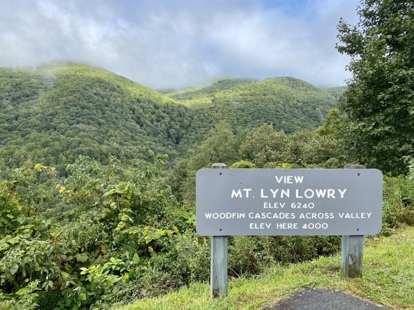
Mt. Lyn Lowry Overlook

National Park Service
Looking south-west from Mt. Lyn Lowry Overlook. Terrain at true elevation.
Access
On the byway
Elevation
4,018 ft
View
Southwest · 240°
Light
Best at sunset
Relief
684 ft drop
In view
3 named features
View from Mt. Lyn Lowry Overlook
NPS Photo / Tina Haver Currin · Public domain (NPS) · NPS
500px provided description: Untitled [#HDR ,#Fall ,#Sunrise ,#Autumn ,#Landscapes ,#Mountains ,#Road ,#North Carolina ,#Haywood County ,#Blue Ridge Parkway ,#HDR Photography ,#Waynesville ,#Great Smoky Mountains ,#Curve ,#Western North Carolina ,#Aaron Morgan Photography]
Aaron Morgan · CC BY-SA 3.0 · source
500px provided description: Untitled [#HDR ,#Fall ,#Sunrise ,#Autumn ,#Landscapes ,#Mountains ,#Road ,#North Carolina ,#Haywood County ,#Blue Ridge Parkway ,#HDR Photography ,#Waynesville ,#Great Smoky Mountains ,#Curve ,#Western North Carolina ,#Aaron Morgan Photography]
Aaron Morgan · CC BY-SA 3.0 · source
This is the historic Balsam Mountain Inn, located along Old Balsam Depot Road in Balsam, North Carolina. Constructed between 1905 and 1908, the large, grand Neoclassical-style hotel features a broad porch with Tuscan columns that spans the length of the facade of the main wing, with windows placed i
Warren LeMay from Cullowhee, NC, United States · CC0 · source
This is the historic Balsam Mountain Inn, located along Old Balsam Depot Road in Balsam, North Carolina. Constructed between 1905 and 1908, the large, grand Neoclassical-style hotel features a broad porch with Tuscan columns that spans the length of the facade of the main wing, with windows placed i
Warren LeMay from Cullowhee, NC, United States · CC0 · source
This is the historic Balsam Mountain Inn, located along Old Balsam Depot Road in Balsam, North Carolina. Constructed between 1905 and 1908, the large, grand Neoclassical-style hotel features a broad porch with Tuscan columns that spans the length of the facade of the main wing, with windows placed i
Warren LeMay from Cullowhee, NC, United States · CC0 · source

What you’re looking at

Named terrain inside the view from this overlook, nearest first.

  • Wesner Bald Overlook (MP 448.1)4,990 ftwest-northwest · 1.1 mi
  • Judaculla Mountain3,383 ftsouth-southwest · 1.3 mi
  • Joe Mountain3,474 ftsouthwest · 2.9 mi

Light

This overlook faces sunset — 30° off square to it.

DateSunriseSunsetGolden hour
March equinox07:3719:4419:11
June solstice06:1820:5220:14
September equinox07:2119:3118:57
December solstice07:3817:2416:45

Local time (America/New_York). Computed for this exact position.

Where it is

  • Asheville32.5 mi east-northeast
  • Hendersonville36.8 mi east-southeast
  • Sevierville39.4 mi northwest
Loading map…
Private beta · Free to join

Take the scenic way to Mt. Lyn Lowry Overlook.

Byway plans around your taste, verified places, real weather and opening hours — then opens every leg in Google Maps with one tap.

Private beta · Free to join · No card · Invite when a spot opens

Mt. Lyn Lowry Overlook · National Park Service

This overlook has plenty to offer. Not only can you take in a beautiful view of Mt. Lyn Lowry (elevation 6,240 feet), there is also a wide picnic area, gorgeous cascade, and significant history associated with the area.   This mountain was renamed in 1965 in memory of Lyn Lowry, a 15-year-old victim of leukemia. Her parents, retired Army Lieutenant General Sumpter Lowry and Ivilyn Lowry, were determined to honor their daughter’s legacy at one of her favorite vacation spots. On the east side of the ridge, Lowry's parents installed a 60-foot-tall cross and a memorial plaque. On a clear day, the cross can be seen from Waynesville, Sylva, and other Western North Carolina towns as far as 30 miles away. The Reverend Billy Graham presided over the dedication ceremony. Across the overlook, the Woodfin Cascades topples down the mountainside. It is best seen in the winter or early springtime when leaves are sparse. But a thin strip of water is visible throughout the summer, especially after a hard rain. There is no easy access to this waterfall, so the best view is from the overlook. Check the conditions of the area before you visit.

Read it at National Park Service →

How high is Mt. Lyn Lowry Overlook?

Mt. Lyn Lowry Overlook sits at about 4,018 feet (1,225 m).

What can you see from Mt. Lyn Lowry Overlook?

From Mt. Lyn Lowry Overlook: Wesner Bald Overlook (MP 448.1) (WNW, 1.1 mi); Judaculla Mountain (SSW, 1.3 mi); Joe Mountain (SW, 2.9 mi).

Is Mt. Lyn Lowry Overlook better at sunrise or sunset?

Sunset. The land falls away from Mt. Lyn Lowry Overlook toward the sunset, so at sunrise the light is behind you. Exact times shift through the year; the page shows the current window.

What is the nearest town to Mt. Lyn Lowry Overlook?

Asheville, 33 miles ENE of Mt. Lyn Lowry Overlook.

What is the next lookout after Mt. Lyn Lowry Overlook?

Balsam Gap Overlook is the next surfaced lookout along the same route after Mt. Lyn Lowry Overlook.

Drive to Mt. Lyn Lowry Overlook with Byway

Byway plans the scenic way there — real places along Blue Ridge Parkway, real weather, zero hallucinations — and hands the turns to the navigation you already use.

Byways with this lookout

Locals make it Verified.

Mt. Lyn Lowry Overlook — confirmed, rated, and photographed by people who actually pulled over. A local confirmation is what upgrades a lookout from Discovered to Verified. Zero hallucinations.

Confirmed by locals

No local confirmations yet. Stood here? Yours is the one that upgrades this lookout to Verified.

Ratings

No ratings yet. Stood at this lookout? Be the first to rate it.

No written reviews yet.

Field notes

No field notes yet. Know the gate hours or the best pull-in? Leave the note you wish you'd had.

Photos

No photos yet.

Sign in to confirm this lookout, rate it, add photos, and leave field notes.

More lookouts on Blue Ridge Parkway

Named places near this lookout