Skip to content

Sandy Bottom Overlook

National Park Service
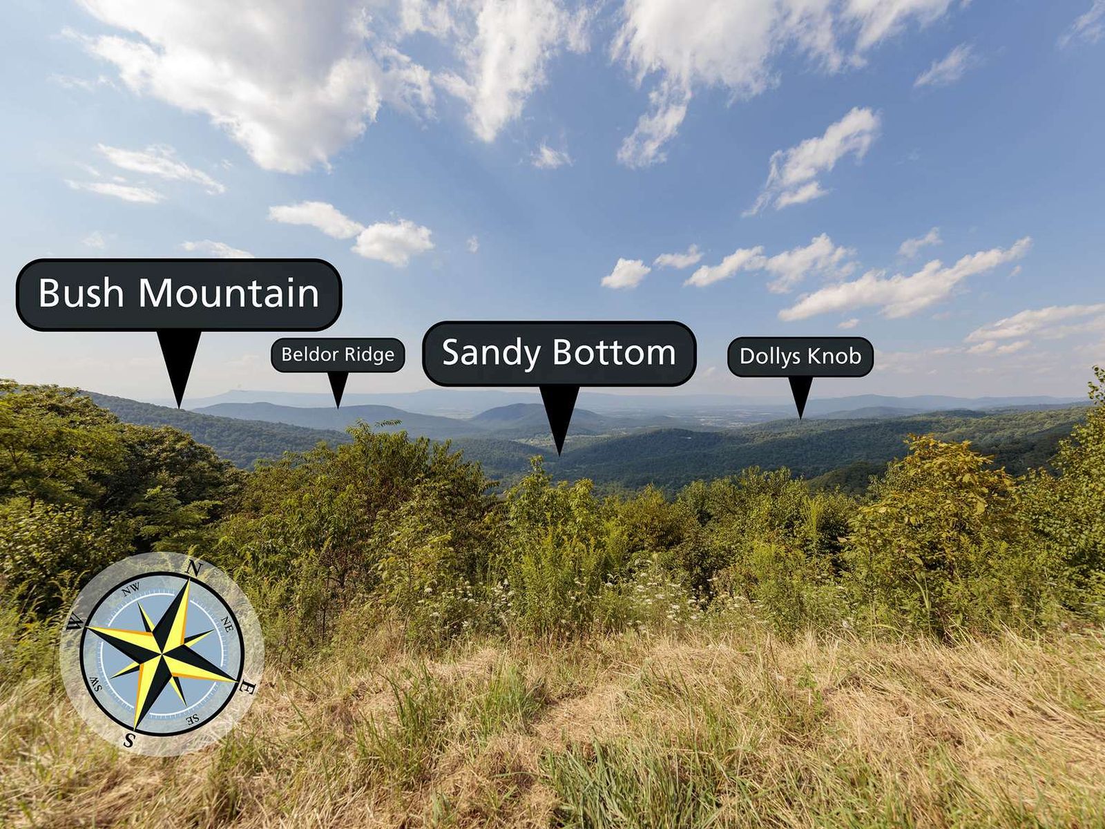
Looking north-west from Sandy Bottom Overlook. Terrain and imagery at true elevation.

Sandy Bottom Overlook sits at 2,697 feet on Skyline Drive, facing 330 degrees toward the Shenandoah Valley. The land drops 731 feet within 600 meters of the overlook, giving an open view down onto the foothills of the Blue Ridge Mountains as they descend into the valley below. The small community of Sandy Bottom lies in the valley beneath the overlook. Visible peaks and features include Bush Mountain to the west at 1.0 mile, Hanse Mountain and Giants Grave to the northwest, Dollys Knob to the north-northwest, Huckleberry Mountain to the north, Abrams Mountain to the north-northeast, and the more distant Elkton Spring and Bear Lithia Spring to the north-northwest. Harrisonburg lies 18.2 miles to the west-northwest, with Charlottesville 21.7 miles to the south-southeast and Staunton 30.4 miles to the west-southwest. The overlook falls between Swift Run Overlook and Bacon Hollow Overlook along the drive. This section of the Shenandoah Valley was historically more sparsely populated than the northern valley; when turnpikes were built in the 1790s to link towns to trade routes further east, smaller communities here were often bypassed in favor of faster routes between larger towns.

Access
On the byway
Elevation
2,697 ft
View
Northwest · 330°
Relief
731 ft drop
In view
8 named features
What's the view from Sandy Bottom Overlook?
National Park Service · Public domain (NPS) · NPS
View south along Shenandoah National Park's Skyline Drive just south of the Sandy Bottom Overlook in Rockingham County, Virginia
Famartin · CC BY-SA 4.0 · source
View northwest from the Sandy Bottom Overlook along Shenandoah National Park's Skyline Drive in Rockingham County, Virginia
Famartin · CC BY-SA 4.0 · source
View west-northwest from the Sandy Bottom Overlook along Shenandoah National Park's Skyline Drive in Rockingham County, Virginia
Famartin · CC BY-SA 4.0 · source
View north-northwest from the Sandy Bottom Overlook along Shenandoah National Park's Skyline Drive in Rockingham County, Virginia
Famartin · CC BY-SA 4.0 · source
View north from the Sandy Bottom Overlook along Shenandoah National Park's Skyline Drive in Rockingham County, Virginia
Famartin · CC BY-SA 4.0 · source

What you’re looking at

Named terrain inside the view from this overlook, nearest first.

  • Bush Mountain2,694 ftwest · 1.0 mi
  • Hanse Mountain2,122 ftnorthwest · 3.9 mi
  • Dollys Knob1,536 ftnorth-northwest · 3.9 mi
  • Huckleberry Mountain2,132 ftnorth · 4.7 mi
  • Giants Grave1,290 ftnorthwest · 4.8 mi
  • Elkton Spring1,033 ftnorth-northwest · 5.1 mi
  • Abrams Mountain2,018 ftnorth-northeast · 5.7 mi
  • Bear Lithia Spring955 ftnorth-northwest · 7.5 mi

Light

DateSunriseSunsetGolden hour
March equinox07:1919:2618:51
June solstice05:5220:4220:02
September equinox07:0319:1318:38
December solstice07:2816:5816:16

Local time (America/New_York). Computed for this exact position.

Where it is

  • Harrisonburg18.2 mi west-northwest
  • Charlottesville21.7 mi south-southeast
  • Staunton30.4 mi west-southwest
Loading map…
Private beta · Free to join

Take the scenic way to Sandy Bottom Overlook.

Byway plans around your taste, verified places, real weather and opening hours — then opens every leg in Google Maps with one tap.

Private beta · Free to join · No card · Invite when a spot opens

Sandy Bottom Overlook · National Park Service

From Sandy Bottom Overlook you will see the foothills of the Blue Ridge Mountains descending to the Shenandoah Valley below. Sandy Bottom is the small community in the valley. The southern section of the Shenandoah Valley is historically more sparsely populated and remote than the northern section. In the 1790s when turnpikes arose as a means of connecting towns and villages to larger trade routes further east, smaller enclaves in the southern end of the valley were often bypassed in favor of faster routes between larger towns.

Maintenance of this view funded by Rockingham County Tourism through the Shenandoah National Park Trust Adopt an Overlook program.

Read it at National Park Service

How high is Sandy Bottom Overlook?

Sandy Bottom Overlook sits at about 2,697 feet (822 m).

What can you see from Sandy Bottom Overlook?

From Sandy Bottom Overlook: Bush Mountain (W, 1.0 mi); Hanse Mountain (NW, 3.9 mi); Dollys Knob (NNW, 3.9 mi); Huckleberry Mountain (N, 4.7 mi).

What is the nearest town to Sandy Bottom Overlook?

Harrisonburg, 18 miles WNW of Sandy Bottom Overlook.

What is the next lookout after Sandy Bottom Overlook?

Bacon Hollow Overlook is the next surfaced lookout along the same route after Sandy Bottom Overlook.

Drive to Sandy Bottom Overlook with Byway

Byway plans the scenic way there — real places along Skyline Drive, real weather, zero hallucinations — and hands the turns to the navigation you already use.

Byways with this lookout

Day trips start here

Locals make it Verified.

Sandy Bottom Overlook — confirmed, rated, and photographed by people who actually pulled over. A local confirmation is what upgrades a lookout from Discovered to Verified. Zero hallucinations.

Confirmed by locals

No local confirmations yet. Stood here? Yours is the one that upgrades this lookout to Verified.

Ratings

No ratings yet. Stood at this lookout? Be the first to rate it.

No written reviews yet.

Field notes

No field notes yet. Know the gate hours or the best pull-in? Leave the note you wish you'd had.

Photos

No photos yet.

Sign in to confirm this lookout, rate it, add photos, and leave field notes.

More lookouts on Skyline Drive

Named places near this lookout