Skip to content

Shafer Canyon Overlook

National Park Service
Looking north-east from Shafer Canyon Overlook. Terrain and imagery at true elevation.

Shafer Canyon Overlook sits at mile 28, the final stop on the Dead Horse Point Mesa Scenic Byway, at 5,709 feet. The land drops 1,020 feet within 600 meters of the viewpoint, and the view faces 60°, roughly toward sunrise. Several other viewpoints are visible from here: Bird's View Butte & Crow's Head Spires Overlook to the northeast at 3.9 miles, Meander Overlook and Dead Horse Point to the east-northeast at 4.3 and 4.4 miles, Rim Overlook to the northeast at 4.4 miles, Big Horn Overlook to the northeast at 4.8 miles, and Basin Overlook to the east-northeast at 5.0 miles.

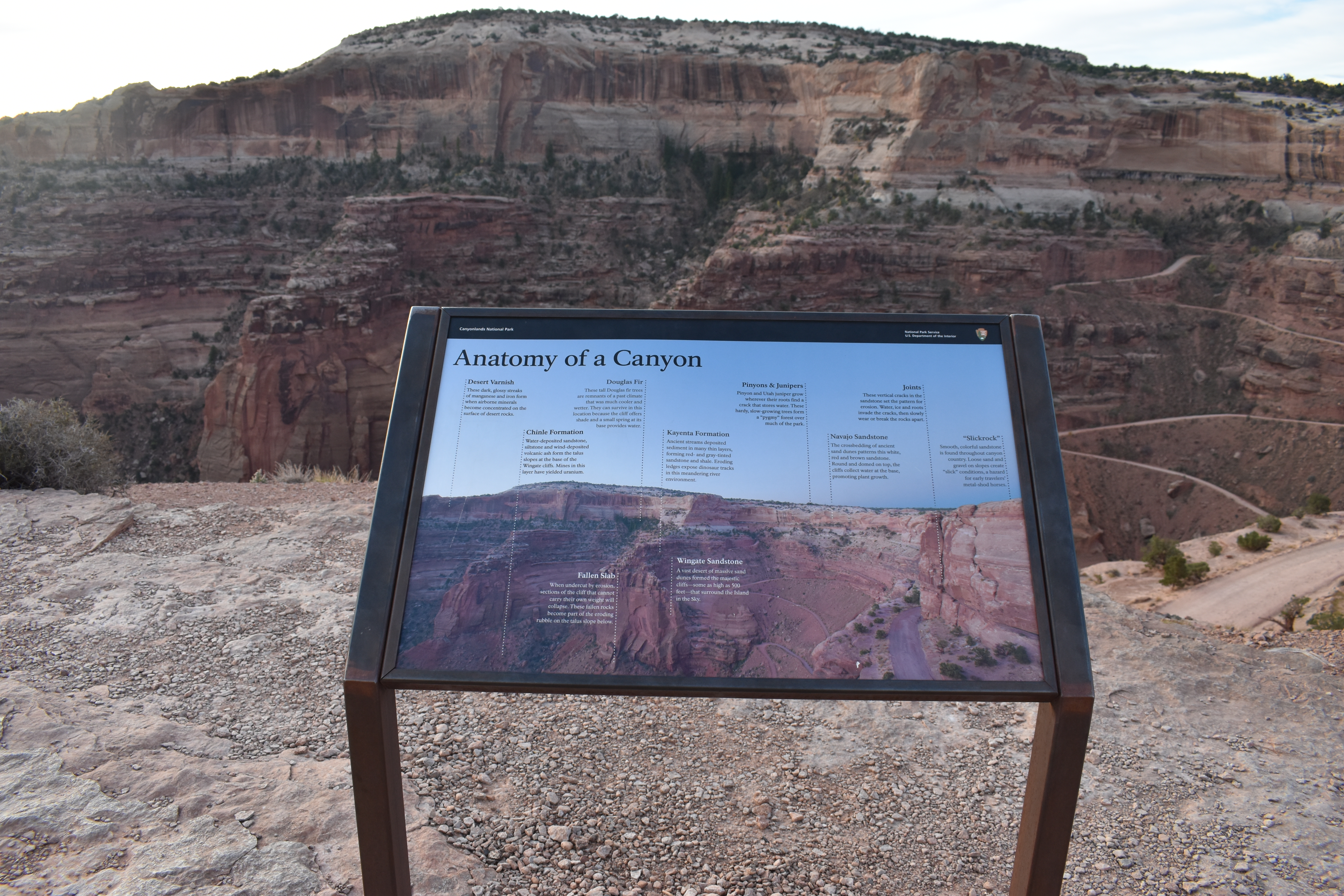
The rock layers exposed in the canyon include desert varnish streaks of manganese and iron on the rock surfaces, the Chinle Formation's water- and wind-deposited sandstone, siltstone, and volcanic ash at the base of the Wingate cliffs, and fallen slabs that have collapsed from the cliff face onto the talus slope. Douglas fir trees grow in shaded, spring-fed spots near the cliff. The Kayenta Formation shows thin layers of red and gray sandstone and shale with exposed dinosaur tracks, while Wingate Sandstone forms cliffs up to 500 feet high from ancient dune fields. Pinyon and juniper grow in rock cracks, and Navajo Sandstone displays crossbedded patterns from ancient dunes. Vertical joints and smooth "slickrock" surfaces are also visible. Moab lies 16.9 miles east-northeast; Castle Valley is 25.6 miles east-northeast. Sevenmile Canyon Overlook is the previous stop along the byway.

Position
Mile ~28 of 28
Access
0.3 mi detour
Elevation
5,709 ft
View
Northeast · 60°
Light
Best at sunrise
Relief
1,020 ft drop
In view
6 named features
A sign at the shafer canyon overlook provides information on the anatomy of the canyon.
E. Butko · Public domain (NPS) · NPS
Canyonlands National Park is a U.S. National Park located in southeastern Utah near the town of Moab and preserves a colorful landscape eroded into countless canyons, mesas and buttes by the Colorado River, the Green River, and their respective tributaries. The park is divided into four districts: t
Ken Lund from Reno, Nevada, USA · CC BY-SA 2.0 · source
Canyonlands National Park is a U.S. National Park located in southeastern Utah near the town of Moab and preserves a colorful landscape eroded into countless canyons, mesas and buttes by the Colorado River, the Green River, and their respective tributaries. The park is divided into four districts: t
Ken Lund from Reno, Nevada, USA · CC BY-SA 2.0 · source
Canyonlands National Park is a U.S. National Park located in southeastern Utah near the town of Moab and preserves a colorful landscape eroded into countless canyons, mesas and buttes by the Colorado River, the Green River, and their respective tributaries. The park is divided into four districts: t
Ken Lund from Reno, Nevada, USA · CC BY-SA 2.0 · source
Canyonlands National Park is a U.S. National Park located in southeastern Utah near the town of Moab and preserves a colorful landscape eroded into countless canyons, mesas and buttes by the Colorado River, the Green River, and their respective tributaries. The park is divided into four districts: t
Ken Lund from Reno, Nevada, USA · CC BY-SA 2.0 · source
Canyonlands National Park is a U.S. National Park located in southeastern Utah near the town of Moab and preserves a colorful landscape eroded into countless canyons, mesas and buttes by the Colorado River, the Green River, and their respective tributaries. The park is divided into four districts: t
Ken Lund from Reno, Nevada, USA · CC BY-SA 2.0 · source

What you’re looking at

Named terrain inside the view from this overlook, nearest first.

  • Bird's View Butte & Crow's Head Spires Overlook5,892 ftnortheast · 3.9 mi
  • Meander Overlook5,924 fteast-northeast · 4.3 mi
  • Dead Horse Point5,933 fteast-northeast · 4.4 mi
  • Rim Overlook5,834 ftnortheast · 4.4 mi
  • Big Horn Overlook5,829 ftnortheast · 4.8 mi
  • Basin Overlook5,937 fteast-northeast · 5.0 mi

Light

This overlook faces sunrise 30° off square to it.

DateSunriseSunsetGolden hour
March equinox07:2419:3118:57
June solstice05:5620:4720:08
September equinox07:0819:1818:43
December solstice07:3417:0316:21

Local time (America/Denver). Computed for this exact position.

Where it is

Mile 28 of 28 along Dead Horse Point Mesa Scenic Byway.

  • Moab16.9 mi east-northeast
  • Castle Valley25.6 mi east-northeast
Loading map…
Private beta · Free to join

Take the scenic way to Shafer Canyon Overlook.

Byway plans around your taste, verified places, real weather and opening hours — then opens every leg in Google Maps with one tap.

Private beta · Free to join · No card · Invite when a spot opens

Shafer Canyon Overlook: Anatomy of a Canyon · National Park Service

From left to right: Desert Varnish: These dark, glossy streaks of manganese and iron form when airborne minerals become concentrated on the surface of desert rocks.           Chinle Formation: Water-deposited sandstone, siltstone and wind-deposited volcanic ash form the talus slopes at the base of the Wingate cliffs. Mines in this layer have yielded uranium.          Fallen Slab: When undercut by erosion, sections of the cliff that cannot carry their own weight will collapse. These fallen rocks become part of the eroding rubble on the talus slope below.       Douglas Fir: These tall Douglas fir trees are remnants of a past climate what was much cooler and wetter. They can survive in this location because the cliff offers shade and a small spring at its base provides water.             Kayenta Formation: Ancient streams deposited sediment in many thin layers, forming red and gray tinted sandstone and shale. Eroding ledges expose dinosaur tracks in this meandering river environment.            Wingate Sandstone: A vast desert of massive sand dunes formed the majestic cliffs - some as high as 500 feet - that surround the Island in the Sky.            Pinyons & Junipers: Pinyon and Utah juniper grow wherever their roots find a crack that stores water. These hardy, slow-growing trees form a "pygmy" forest over much of the park.               Navajo Sandstone: The crossbedding of ancient sand dunes patterns this white, red and brown sandstone. Round and domed on top, the cliffs collect water at the base, promoting plant growth.       Joints: These vertical cracks in the sandstone set the pattern for erosion. Water, ice and roots invade the cracks, then slowly wear or break the rocks apart.           "Slickrock": Smooth, colorful sandstone is found throughout the canyon country. Loose sand and gravel on slopes create "slick" conditions, a hazard for early travelers' metal-shod horses.

Read it at National Park Service

How high is Shafer Canyon Overlook?

Shafer Canyon Overlook sits at about 5,709 feet (1,740 m).

What can you see from Shafer Canyon Overlook?

From Shafer Canyon Overlook: Bird's View Butte & Crow's Head Spires Overlook (NE, 3.9 mi); Meander Overlook (ENE, 4.3 mi); Dead Horse Point (ENE, 4.4 mi); Rim Overlook (NE, 4.4 mi).

Is Shafer Canyon Overlook better at sunrise or sunset?

Sunrise. The land falls away from Shafer Canyon Overlook toward the sunrise, so at sunset the light is behind you. Exact times shift through the year; the page shows the current window.

What is the nearest town to Shafer Canyon Overlook?

Moab, 17 miles ENE of Shafer Canyon Overlook.

Drive to Shafer Canyon Overlook with Byway

Byway plans the scenic way there — real places along Dead Horse Point Mesa Scenic Byway, real weather, zero hallucinations — and hands the turns to the navigation you already use.

Byways with this lookout

Day trips start here

Locals make it Verified.

Shafer Canyon Overlook — confirmed, rated, and photographed by people who actually pulled over. A local confirmation is what upgrades a lookout from Discovered to Verified. Zero hallucinations.

Confirmed by locals

No local confirmations yet. Stood here? Yours is the one that upgrades this lookout to Verified.

Ratings

No ratings yet. Stood at this lookout? Be the first to rate it.

No written reviews yet.

Field notes

No field notes yet. Know the gate hours or the best pull-in? Leave the note you wish you'd had.

Photos

No photos yet.

Sign in to confirm this lookout, rate it, add photos, and leave field notes.

More lookouts on Dead Horse Point Mesa Scenic Byway

Named places near this lookout