Skip to content

The Valley Overlook

National Park Service
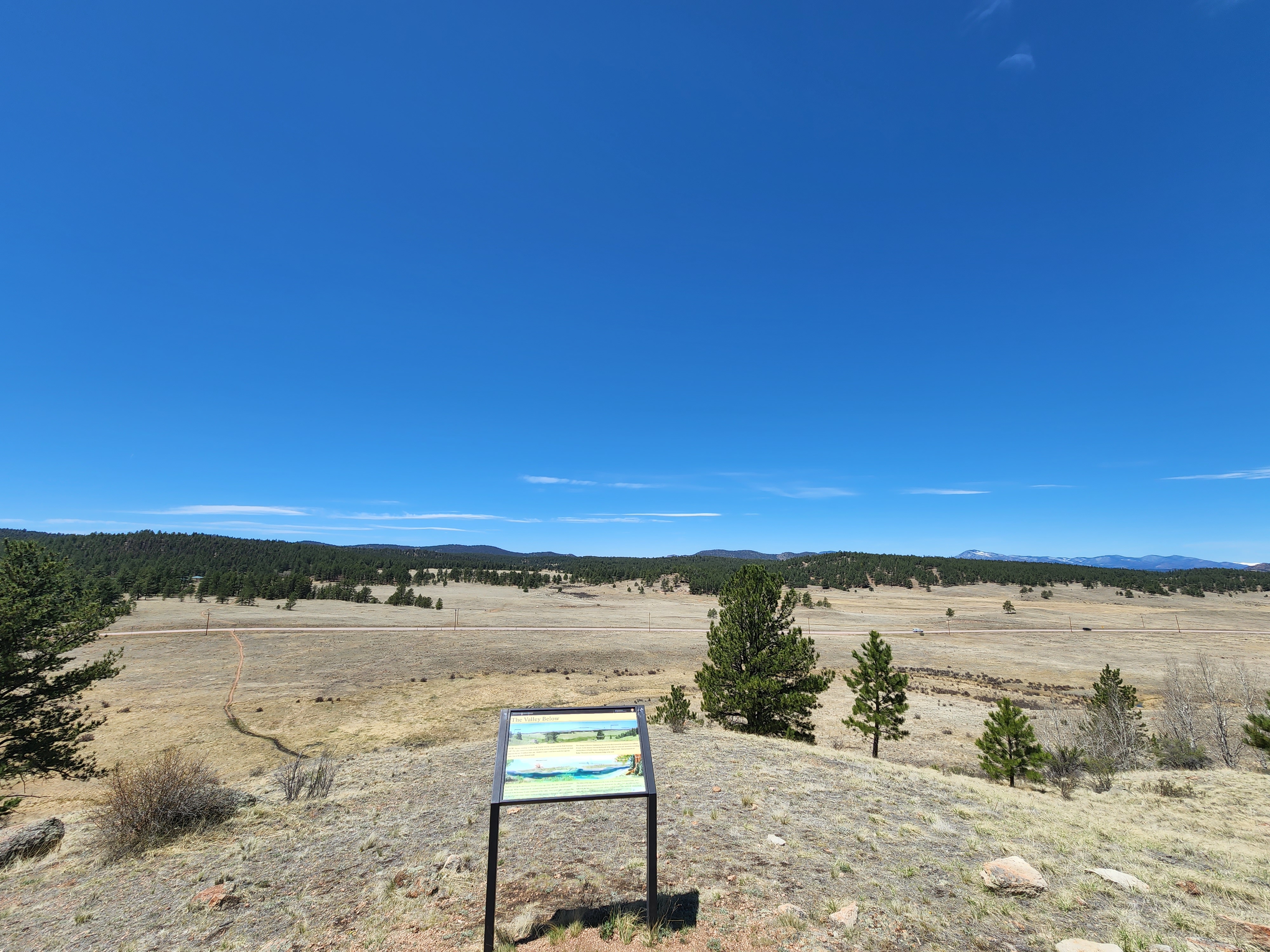
Looking north-west from The Valley Overlook. Terrain and imagery at true elevation.

The Valley Overlook sits at 8,401 feet along the Gold Belt Tour, facing 330 degrees toward the Florissant valley, with the land dropping 91 feet within 600 meters of the viewpoint. The Big Stump is visible to the west at 0.4 miles, while Crystal Peak rises to the north at 5.4 miles (9,595 ft) and Tappan Mountain stands north-northwest at 12.3 miles (8,937 ft). The valley below once held a lake that produced fossil-rich shale deposits, and Grape Creek now runs northward through the same ground where water once flowed south before the area tilted through mountain building. A stratovolcano once stood 18 miles southwest during the Eocene, though it has since eroded away, leaving only traces of its past influence on the valley's geology and fossil formation. Colorado Springs lies 25.1 miles east-southeast, Fountain is 35.1 miles east-southeast, and Castle Rock is 38.7 miles northeast. Sunrise and sunset times vary by season, from a 05:37 sunrise at the June solstice to a 07:17 sunrise at the December solstice. The Geologic Overlook is the next stop along the route.

Access
On the byway
Elevation
8,401 ft
View
Northwest · 330°
Relief
91 ft drop
In view
3 named features
A view from the Geologic Overlook
NPS Photo: Lauren Rice · Public domain (NPS) · NPS
Petrified sequoia tree stumps A beautiful mountain valley just west of Pikes Peak holds spectacular remnants of the earth's prehistoric life. Huge petrified redwoods and incredibly detailed fossils of ancient insects and plants reveal a very different Colorado of long ago. Almost 35 million years ag
NPS staff · Public domain · source
Petrified sequoia tree stumps A beautiful mountain valley just west of Pikes Peak holds spectacular remnants of the earth's prehistoric life. Huge petrified redwoods and incredibly detailed fossils of ancient insects and plants reveal a very different Colorado of long ago. Almost 35 million years ag
NPS staff · Public domain · source
Petrified sequoia tree stumps A beautiful mountain valley just west of Pikes Peak holds spectacular remnants of the earth's prehistoric life. Huge petrified redwoods and incredibly detailed fossils of ancient insects and plants reveal a very different Colorado of long ago. Almost 35 million years ag
NPS staff · Public domain · source
Petrified leaf A beautiful mountain valley just west of Pikes Peak holds spectacular remnants of the earth's prehistoric life. Huge petrified redwoods and incredibly detailed fossils of ancient insects and plants reveal a very different Colorado of long ago. Almost 35 million years ago, enormous vol
NPS staff · Public domain · source
Petrified sequoia tree stumps A beautiful mountain valley just west of Pikes Peak holds spectacular remnants of the earth's prehistoric life. Huge petrified redwoods and incredibly detailed fossils of ancient insects and plants reveal a very different Colorado of long ago. Almost 35 million years ag
NPS staff · Public domain · source

What you’re looking at

Named terrain inside the view from this overlook, nearest first.

  • The Big Stump8,416 ftwest · 0.4 mi
  • Crystal Peak9,595 ftnorth · 5.4 mi
  • Tappan Mountain8,937 ftnorth-northwest · 12.3 mi

Light

DateSunriseSunsetGolden hour
March equinox07:0519:1318:38
June solstice05:3720:3119:51
September equinox06:5019:0018:25
December solstice07:1716:4316:01

Local time (America/Denver). Computed for this exact position.

Where it is

  • Colorado Springs25.1 mi east-southeast
  • Fountain35.1 mi east-southeast
  • Castle Rock38.7 mi northeast
Loading map…
Private beta · Free to join

Take the scenic way to The Valley Overlook.

Byway plans around your taste, verified places, real weather and opening hours — then opens every leg in Google Maps with one tap.

Private beta · Free to join · No card · Invite when a spot opens

The Valley Overlook · National Park Service

Geoheritage Highlight! The natural beauty of landscapes links us to Geoheritage and causes us to wonder how these landscapes formed. From this high vantage point, you can visualize how the Florissant valley has changed through geologic time and wonder about its future This location offers a panoramic view across the Monument’s main valley and to the distant mountains beyond. The valley was once covered by a forest with about 150 different species of trees and shrubs now preserved as fossils. Tall redwoods formed the Eocene forest canopy, and many kinds of hardwood trees grew in the forest understory. Today’s sparse montane conifer forest has far fewer species and consists mostly of pines and spruce with scattered aspens and several kinds of shrubs. This change in the forest over geologic time provides clues for big changes in climate too, as there was a major cooling of temperature during the past 34 million years. Not all of the mountains on the horizon were present during the Eocene, yet one of the tall geologic features of that time was the Guffey volcano, which later eroded away, now leaving only traces of its past.  . 

Valley Today Looking west from a hill across the valley, it is possible to imagine the lake that once filled it and left behind the fossil-rich shale deposits. Today, the only water running through the valley is Grape Creek, a northward-flowing waterway. In the distant past, water within the valley flowed southward, but as the area was tilted through mountain building processes, the direction of waterflow changed.  

Eocene Lake During the Eocene, 34.07 million years ago, the valley was much warmer than today. A stratovolcano towered on the horizon 18 miles southwest of the valley. Now mostly lost to erosion, this volcano once had a major impact on the geologic history of the valley and the formation of Florissant's fossils.

Read it at National Park Service

How high is The Valley Overlook?

The Valley Overlook sits at about 8,401 feet (2,561 m).

What can you see from The Valley Overlook?

From The Valley Overlook: The Big Stump (W, 0.4 mi); Crystal Peak (N, 5.4 mi); Tappan Mountain (NNW, 12 mi).

What is the nearest town to The Valley Overlook?

Colorado Springs, 25 miles ESE of The Valley Overlook.

What is the next lookout after The Valley Overlook?

Geologic Overlook is the next surfaced lookout along the same route after The Valley Overlook.

Drive to The Valley Overlook with Byway

Byway plans the scenic way there — real places along Gold Belt Tour, real weather, zero hallucinations — and hands the turns to the navigation you already use.

Byways with this lookout

Day trips start here

Locals make it Verified.

The Valley Overlook — confirmed, rated, and photographed by people who actually pulled over. A local confirmation is what upgrades a lookout from Discovered to Verified. Zero hallucinations.

Confirmed by locals

No local confirmations yet. Stood here? Yours is the one that upgrades this lookout to Verified.

Ratings

No ratings yet. Stood at this lookout? Be the first to rate it.

No written reviews yet.

Field notes

No field notes yet. Know the gate hours or the best pull-in? Leave the note you wish you'd had.

Photos

No photos yet.

Sign in to confirm this lookout, rate it, add photos, and leave field notes.

More lookouts on Gold Belt Tour

Named places near this lookout