Skip to content

Zabriskie Point

OpenStreetMap
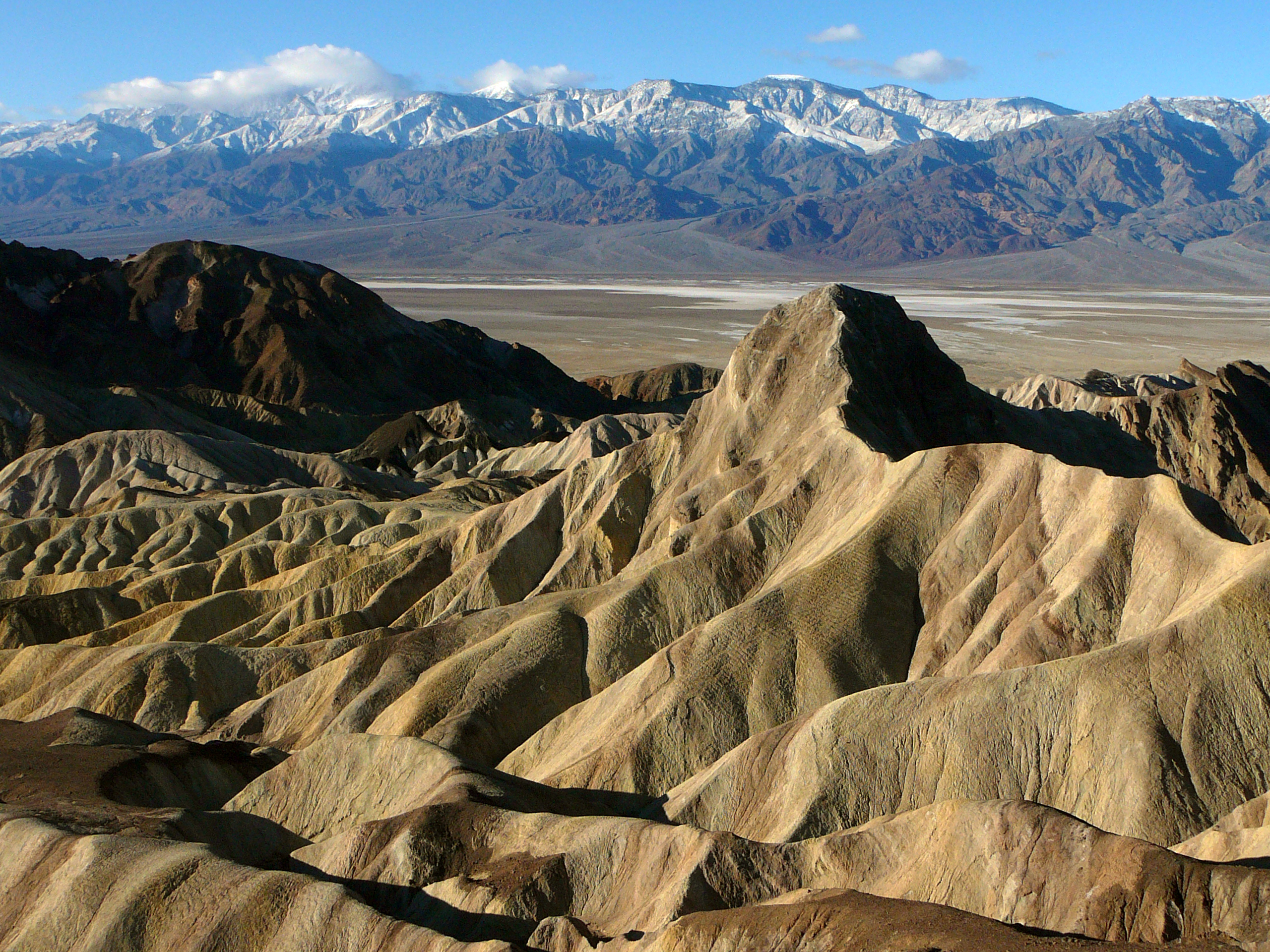
Looking south-west from Zabriskie Point. Terrain and imagery at true elevation.

Zabriskie Point sits at 692 feet along the Death Valley Scenic Byway, with the land dropping 278 feet within 600 meters of the overlook. The view faces 240 degrees, oriented 30 degrees off the direction of sunset. Manly Beacon rises to the west-northwest at 0.8 miles and 799 feet, with Ivan's Folly to the southwest at 1.0 mile and 850 feet. Farther out, Blackwater Spring lies west at 12.9 miles, and a line of higher peaks extends across the west and southwest: Aguereberry Point at 13.8 miles and 6,302 feet, Bald Peak at 17.6 miles and 7,770 feet, Wildrose Peak at 17.9 miles and 9,072 feet, and Tucki Mountain to the west-northwest at 18.5 miles and 6,707 feet. Sunset times shift through the year, from 20:09 at the June solstice to 16:36 at the December solstice, with sunrise ranging from 05:30 in June to 06:56 in December. Amargosa Valley is 22.0 miles to the east-northeast, and Beatty is 33.9 miles north. The overlook is composed of sediments from a lake that dried up five million years ago.

Access
On the byway
Elevation
692 ft
View
Southwest · 240°
Light
Best at sunset
Relief
278 ft drop
In view
7 named features
Views from Zabriskie Point
NPS · Public domain (NPS) · NPS
Manly Beacon, Zabriskie Point , Death Valley National Park , California .
King of Hearts · CC BY-SA 3.0 · source
Red Cathedral, Zabriskie Point , Death Valley National Park , California .
King of Hearts · CC BY-SA 3.0 · source
Zabriskie Point, in Death Valley, California
© Pierre André · CC BY-SA 4.0 · source
Zabriskie Point, in Death Valley, California
© Pierre André · CC BY-SA 4.0 · source
Zabriskie Point in Death Valley . en:CaliforniaCalifornia (USA).
© Pierre André · CC BY-SA 4.0 · source

What you’re looking at

Named terrain inside the view from this overlook, nearest first.

  • Manly Beacon799 ftwest-northwest · 0.8 mi
  • Ivan's Folly850 ftsouthwest · 1.0 mi
  • Blackwater Spring3,334 ftwest · 12.9 mi
  • Aguereberry Point6,302 ftwest-southwest · 13.8 mi
  • Bald Peak7,770 ftwest-southwest · 17.6 mi
  • Wildrose Peak9,072 ftsouthwest · 17.9 mi
  • Tucki Mountain6,707 ftwest-northwest · 18.5 mi

Light

This overlook faces sunset 30° off square to it.

DateSunriseSunsetGolden hour
March equinox06:5218:5918:25
June solstice05:3020:0919:31
September equinox06:3618:4618:12
December solstice06:5616:3615:56

Local time (America/Los_Angeles). Computed for this exact position.

Where it is

  • Amargosa Valley22.0 mi east-northeast
  • Beatty33.9 mi north
Loading map…
Private beta · Free to join

Take the scenic way to Zabriskie Point.

Byway plans around your taste, verified places, real weather and opening hours — then opens every leg in Google Maps with one tap.

Private beta · Free to join · No card · Invite when a spot opens

Zabriskie Point · National Park Service

Zabriskie Point is an iconic Death Valley vista, and a favorite location for viewing sunrise and sunset. The spectacular views from Zabriskie Point are some of the most photographed in Death Valley National Park. Named in honor of Christian Zabriskie, a prominent figure in the heyday of the Pacific Coast Borax Company, Zabriskie Point affords an elevated vista from which to marvel at the badlands below. These yellow and brown stripped hills have been shaped by the powerful force of water, and even during dry times, the path carved by this water is unmistakable. Gazing beyond the badlands, views of the salt flats covering the floor of Death Valley are visible in the distance, with the hulk of the Panamint Mountains towering above.   The most pronounced feature viewed from Zabriskie Point is Manly Beacon. This jutting high point rises to an elevation of 823 ft (251 m), and bears the name of one of the first 49ers (gold rush pioneers) to visit the area. Manly Beacon is especially magnificent when viewed at sunrise or sunset.     A 15 minute drive east on Highway 190 from Furnace Creek Visitor Center will bring you to the parking area for this not-to-be-missed view point. From the parking lot, the point is a ¼ mile (400 m) walk up a hill on a paved trail. Those interested in hiking in the badlands can pick up the Badlands Loop Trail at the Zabriskie Point parking lot. Hiking distance varies depending on the route chosen: longer hikes can include Gower Gulch, Golden Canyon, and Red Cathedral.

Read it at National Park Service

WikipediaCC BY-SA

Zabriskie Point is a part of the Amargosa Range located east of Death Valley in Death Valley National Park in California, United States, noted for its erosional landscape. It is composed of sediments from Furnace Creek Lake, which dried up 5 million years ago—long before Death Valley came into existence.

Read it at Wikipedia

How high is Zabriskie Point?

Zabriskie Point sits at about 692 feet (211 m).

What can you see from Zabriskie Point?

From Zabriskie Point: Manly Beacon (WNW, 0.8 mi); Ivan's Folly (SW, 1.0 mi); Blackwater Spring (W, 13 mi); Aguereberry Point (WSW, 14 mi).

Is Zabriskie Point better at sunrise or sunset?

Sunset. The land falls away from Zabriskie Point toward the sunset, so at sunrise the light is behind you. Exact times shift through the year; the page shows the current window.

What is the nearest town to Zabriskie Point?

Amargosa Valley, 22 miles ENE of Zabriskie Point.

Drive to Zabriskie Point with Byway

Byway plans the scenic way there — real places along Death Valley Scenic Byway, real weather, zero hallucinations — and hands the turns to the navigation you already use.

Byways with this lookout

Day trips start here

Locals make it Verified.

Zabriskie Point — confirmed, rated, and photographed by people who actually pulled over. A local confirmation is what upgrades a lookout from Discovered to Verified. Zero hallucinations.

Confirmed by locals

No local confirmations yet. Stood here? Yours is the one that upgrades this lookout to Verified.

Ratings

No ratings yet. Stood at this lookout? Be the first to rate it.

No written reviews yet.

Field notes

No field notes yet. Know the gate hours or the best pull-in? Leave the note you wish you'd had.

Photos

No photos yet.

Sign in to confirm this lookout, rate it, add photos, and leave field notes.

More lookouts on Death Valley Scenic Byway

Named places near this lookout