Skip to content

Blacktail Ponds Overlook

VerifiedOpenStreetMap + National Park Service
Blacktail Ponds Overlook — direction of view not recorded. Terrain at true elevation.

Blacktail Ponds Overlook sits at 6,514 feet along the Wyoming Centennial Scenic Byway, with the land dropping 52 feet within 600 meters of the site. The view takes in a Rock Face to the south at 0.4 miles (6,659 ft), Glacier Overlook to the northeast at 2.0 miles (6,643 ft), and the Laurance S. Rockefeller Preserve to the southwest at 4.8 miles (6,411 ft). From this point, ponds and wet meadows along the Snake River mark the wetland community, with terraces rising to sagebrush flats across the valley floor. Lodgepole pines grow on glacial moraines ringing glacial lakes, while aspen and conifer forests cover the lower mountain slopes, and an alpine community holds to rocky ground at the highest elevations. The site is named for "blacktail" deer, now known as mule deer, that frequent the area. Jackson lies 13.3 miles to the south-southwest, Wilson 14.6 miles southwest, and Alpine 38.3 miles south-southwest. Mormon Row Viewpoint precedes this stop on the byway, and Flat Creek Overlook follows. Sunrise and sunset vary by season, from a 05:42 sunrise at the June solstice to a 16:49 sunset at the December solstice.

Access
On the byway
Elevation
6,514 ft
Relief
52 ft drop
In view
3 named features
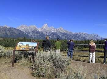
Visitors at Blacktail Ponds Overlook
National Park Service · Public domain (NPS) · NPS
(1 in a multiple picture set) These is a telephoto shot of the previuos scene, giving a closer view of the ranch building and the horse (can you see him?). Wouldn't this be a beautiful place to live (except in the winter!)?
inkknife_2000 (7.5 million views +) · CC BY-SA 2.0 · source
Chapel of the Transfiguration , alter window view, Grand Teton National Park.
Magicpiano · CC BY-SA 4.0 · source
My first attempt at stitching together vertical shots for a panorama (in order to have more depth of field). I ended up liking the "fisheye" appearance to the foreground created by the stitching.
Sheila Sund from Salem, United States · CC BY 2.0 · source
As we were driving to a float trip down the Snake River, there was lightning and hail. Luckily, the storm was moving away and 15 minutes after this, the sun came out.
Sheila Sund from Salem, United States · CC BY 2.0 · source
Aerial image of the Cathedral Group of the Teton Range (view from the southeast)
Carsten Steger · CC BY-SA 4.0 · source

What you’re looking at

Named terrain around this overlook, nearest first. No view direction is recorded, so every bearing is listed.

  • Rock Face6,659 ftsouth · 0.4 mi
  • Glacier Overlook6,643 ftnortheast · 2.0 mi
  • Laurance S. Rockefeller Preserve6,411 ftsouthwest · 4.8 mi

Light

DateSunriseSunsetGolden hour
March equinox07:2719:3518:57
June solstice05:4221:0920:25
September equinox07:1119:2218:44
December solstice07:5416:4916:02

Local time (America/Denver). Computed for this exact position.

Where it is

  • Jackson13.3 mi south-southwest
  • Wilson14.6 mi southwest
  • Alpine38.3 mi south-southwest
Loading map…
Private beta · Free to join

Take the scenic way to Blacktail Ponds Overlook.

Byway plans around your taste, verified places, real weather and opening hours — then opens every leg in Google Maps with one tap.

Private beta · Free to join · No card · Invite when a spot opens

Blacktail Ponds Overlook · National Park Service

From this vantage point, the park's natural communities stretch out before you. The ponds and wet meadows along the Snake River are home to the wetland community. Terraces step up from the Snake River to the sagebrush community covering much of the valley floor. Islands of lodgepole pines take root on glacial moraines that ring glacial lakes. The lower slopes of the mountains support aspen and conifer forest communities. At the highest elevations, the alpine community clings to the rocky substrate seeking shelter.

Name Origin Named for "blacktail" deer now known as mule deer that frequent the area.

Read it at National Park Service →

How high is Blacktail Ponds Overlook?

Blacktail Ponds Overlook sits at about 6,514 feet (1,985 m).

What can you see from Blacktail Ponds Overlook?

From Blacktail Ponds Overlook: Rock Face (S, 0.4 mi); Glacier Overlook (NE, 2.0 mi); Laurance S. Rockefeller Preserve (SW, 4.8 mi).

What is the nearest town to Blacktail Ponds Overlook?

Jackson, 13 miles SSW of Blacktail Ponds Overlook.

What is the next lookout after Blacktail Ponds Overlook?

Flat Creek Overlook is the next surfaced lookout along the same route after Blacktail Ponds Overlook.

Drive to Blacktail Ponds Overlook with Byway

Byway plans the scenic way there — real places along Wyoming Centennial Scenic Byway, real weather, zero hallucinations — and hands the turns to the navigation you already use.

Byways with this lookout

Day trips start here

Locals make it Verified.

Blacktail Ponds Overlook — confirmed, rated, and photographed by people who actually pulled over. A local confirmation is what upgrades a lookout from Discovered to Verified. Zero hallucinations.

Confirmed by locals

No local confirmations yet. Stood here? Yours is the one that upgrades this lookout to Verified.

Ratings

No ratings yet. Stood at this lookout? Be the first to rate it.

No written reviews yet.

Field notes

No field notes yet. Know the gate hours or the best pull-in? Leave the note you wish you'd had.

Photos

No photos yet.

Sign in to confirm this lookout, rate it, add photos, and leave field notes.

More lookouts on Wyoming Centennial Scenic Byway

Named places near this lookout