Skip to content

Snake River Overlook

VerifiedOpenStreetMap + National Park Service
Looking west from Snake River Overlook. Terrain and imagery at true elevation.

Snake River Overlook sits at 6,879 feet on the Wyoming Centennial Scenic Byway, facing west toward the Teton Range, with the land dropping 262 feet within 600 meters of the point. The view west takes in a line of named peaks and features across roughly 6 to 7 miles, including Baxter's Pinnacle at 8,481 feet, Cube Point at 9,583 feet, Hangover Pinnacle at 9,540 feet, and Storm Point at 9,942 feet, along with Hidden Falls, Ribbon Cascade, and the viewpoints of Inspiration Point and Bradley Lake. Because the overlook faces due west, the light here runs toward sunset, with sunset times ranging from 16:49 in December to 21:09 in June. Jackson lies 20.1 miles to the south-southwest, with Wilson and Victor farther beyond in the same general direction. The site is preceded on the byway by Togwotee Overlook Interpretive Site and followed by Teton Point Overlook.

Access
On the byway
Elevation
6,879 ft
View
West · 270°
Light
Best at sunset
Relief
262 ft drop
In view
9 named features
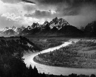
Ansel Adams: Tetons and the Snake River
National Park Service · Public domain (NPS) · NPS
Teton Range from the Snake River Overlook
Fredlyfish4 · CC BY-SA 4.0 · source
Snake River overlook
Thomson M · CC BY 3.0 · source
This is the spot that Ansel Adams made famous: <a href=" https://artmuseum.princeton.edu/collections/objects/15302 " rel="noreferrer nofollow">artmuseum.princeton.edu/collections/objects/15302</a> Makes a big difference when you are Ansel Adams, it's not raining, you have time to get to
Pedro Szekely from Los Angeles, USA · CC BY-SA 2.0 · source
Snake River and Tetons
Sam Beebe/Ecotrust · CC BY-SA 3.0 · source
500px provided description: overcast skies clearing the mountains, leaving misty conditions in the valley [#sky ,#forest ,#fall ,#misty ,#distance ,#foggy ,#overlook ,#plains ,#tetons ,#moutnains ,#storm leaving the tetons]
Christian Collins · CC BY-SA 3.0 · source

What you’re looking at

Named terrain inside the view from this overlook, nearest first.

  • Inspiration Point7,250 ftwest · 6.3 mi
  • Hidden Falls (and ground squirrels dining room)7,096 ftwest · 6.4 mi
  • Hidden Falls7,288 ftwest · 6.4 mi
  • Ribbon Cascade8,196 ftwest-northwest · 6.5 mi
  • Baxter's Pinnacle8,481 ftwest-northwest · 6.5 mi
  • Cube Point9,583 ftwest-northwest · 6.8 mi
  • Hangover Pinnacle9,540 ftwest · 7.0 mi
  • Bradley Lake7,043 ftwest-southwest · 7.0 mi
  • Storm Point9,942 ftwest · 7.1 mi

Light

This overlook faces sunset 0° off square to it.

DateSunriseSunsetGolden hour
March equinox07:2719:3518:57
June solstice05:4121:0920:25
September equinox07:1019:2218:44
December solstice07:5416:4916:02

Local time (America/Denver). Computed for this exact position.

Where it is

  • Jackson20.1 mi south-southwest
  • Wilson21.6 mi southwest
  • Victor26.5 mi west-southwest
Loading map…
Private beta · Free to join

Take the scenic way to Snake River Overlook.

Byway plans around your taste, verified places, real weather and opening hours — then opens every leg in Google Maps with one tap.

Private beta · Free to join · No card · Invite when a spot opens

Snake River Overlook · National Park Service

Ansel Adams photographed this iconic view of the Teton Range and Snake River from roughly this vantage point. The sweep of the Snake River below the sagebrush flats and the high peaks of the Teton Range towering above enthrall all who visit. Today visitors try to capture this image forgetting that trees have grown and the exact location is not known. Below this point, rafters access the Snake River at Deadmans Bar coming downstream from Pacific Creek or continuing on to Moose.

Name OriginThe headwaters for the Snake River are in the Teton Wilderness just outside of Yellowstone National Park. After flowing into Yellowstone briefly, the river cuts through Grand Teton National Park, across Idaho and flows into the Columbia River in Washington.

Previous names include the Lewis River (after Lewis & Clark), La Maudite Riviere Enragee (The Accursed Mad River by French fur trappers), the Mad River, Sho-sho-ne-pah (or Shoshone Indians) that lead to the final name Snake River.

Read it at National Park Service

How high is Snake River Overlook?

Snake River Overlook sits at about 6,879 feet (2,097 m).

What can you see from Snake River Overlook?

From Snake River Overlook: Inspiration Point (W, 6.3 mi); Hidden Falls (and ground squirrels dining room) (W, 6.4 mi); Hidden Falls (W, 6.4 mi); Ribbon Cascade (WNW, 6.5 mi).

Is Snake River Overlook better at sunrise or sunset?

Sunset. The land falls away from Snake River Overlook toward the sunset, so at sunrise the light is behind you. Exact times shift through the year; the page shows the current window.

What is the nearest town to Snake River Overlook?

Jackson, 20 miles SSW of Snake River Overlook.

What is the next lookout after Snake River Overlook?

Teton Point Overlook is the next surfaced lookout along the same route after Snake River Overlook.

Drive to Snake River Overlook with Byway

Byway plans the scenic way there — real places along Wyoming Centennial Scenic Byway, real weather, zero hallucinations — and hands the turns to the navigation you already use.

Byways with this lookout

Day trips start here

Locals make it Verified.

Snake River Overlook — confirmed, rated, and photographed by people who actually pulled over. A local confirmation is what upgrades a lookout from Discovered to Verified. Zero hallucinations.

Confirmed by locals

No local confirmations yet. Stood here? Yours is the one that upgrades this lookout to Verified.

Ratings

No ratings yet. Stood at this lookout? Be the first to rate it.

No written reviews yet.

Field notes

No field notes yet. Know the gate hours or the best pull-in? Leave the note you wish you'd had.

Photos

No photos yet.

Sign in to confirm this lookout, rate it, add photos, and leave field notes.

More lookouts on Wyoming Centennial Scenic Byway

Named places near this lookout