Skip to content

Castle Rocks Geological Area Overlook

National Park Service
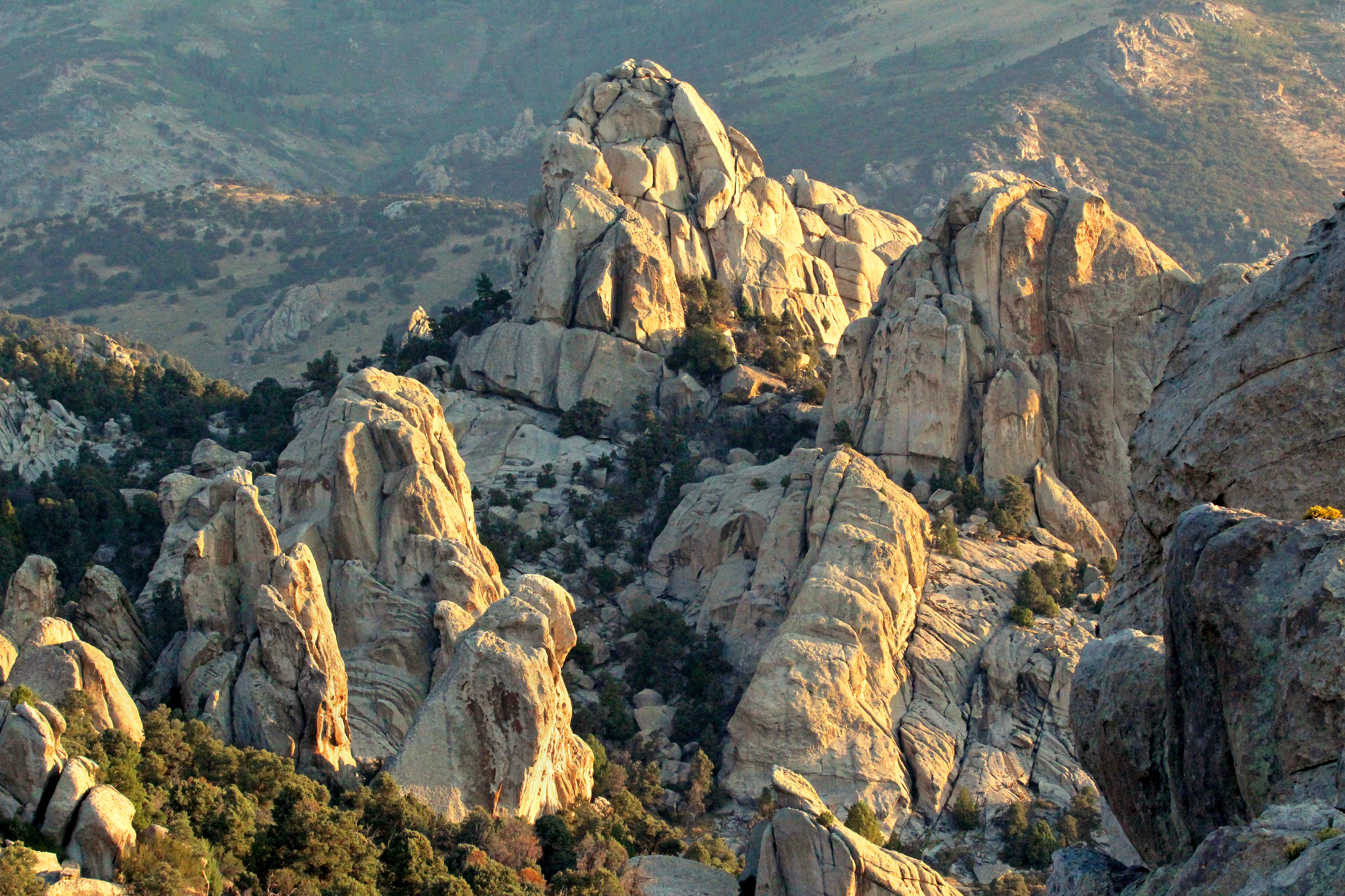
Looking east from Castle Rocks Geological Area Overlook. Terrain and imagery at true elevation.

Castle Rocks Geological Area Overlook sits at 6,093 feet along the City of Rocks Back Country Byway, facing east toward sunrise. The ground drops 182 feet within 600 meters of the viewpoint, giving a sense of the terrain's relief. To the northeast, three fence line features are visible within a mile, at elevations between 6,035 and 6,053 feet, and Thunder Mountain rises to 7,414 feet at a distance of 4.4 miles. Below the ridge lies the Stines Creek riparian area, and the Castle Rocks Geologic Area, with its spires and monoliths of the Almo Pluton, occupies land managed jointly by the State Park, Bureau of Land Management, and Forest Service. The topography here formed through crustal extension, where high-angle faults produced uplifted mountains and dropped valleys, and continued weathering by water, ice, and wind has shaped the rock into its current forms. The nearest towns are Burley, 28.9 miles to the north-northwest, Rupert, 33.9 miles north, and Kimberly, 45.1 miles northwest. The next stop along the byway is Circle Creek Overlook Parking Area.

Access
0.9 mi detour
Elevation
6,093 ft
View
East · 90°
Light
Best at sunrise
Relief
182 ft drop
In view
4 named features
Craggy granite formations jut up in a mountainous landscape glowing in sunrise light.
National Park Service · Public domain (NPS) · NPS
Wood deck handrails leading out to the back yard area. This lawn area is terraced with large boulders. There is a picnic table and fire ring among shade and fruit trees. This is the view from the small deck at the back entrance that leads into a twin bedroom.
NPS Photo · Public domain · source
Long room with wood floors. 8 place dining table, coat rack, leather couch, arm chair, fire place with rock surround, large area rug. The dining table can seat up to 8 people and is right next to the kitchen. There is a gas fireplace to keep you cozy when it gets cold outside.
NPS Photo · Public domain · source
Room with warm wood panels on the walls and ceiling and a grey tile floor. There are windows all around and a door leading out to the deck. There is a desk, chair, and low book shelf with a few books and games. This office space is attached to the master bedroom. There is a private door leading out
NPS Photo · Public domain · source
Mini fridge, microwave, coffee station, table with two chairs, fan, and fireplace style heater. Round yurt structure. It has a clear dome on the ceiling, exposed wood beam ceiling and exposed wood lattice wall supports. The Yurt offers many amenities including a mini fridge, microwave, coffee statio
NPS Photo · Public domain · source
Wood floor, queen bed, side tables with lamps, large dresser, and flat screen tv. Master bedroom, queen bed, side tables with lamps, large dresser, and flat screen tv. There is also an attached office.
NPS Photo · Public domain · source

What you’re looking at

Named terrain inside the view from this overlook, nearest first.

  • Fence Line - Southwest6,053 ftnortheast · 0.7 mi
  • Fence Line - Alcove6,035 ftnortheast · 0.8 mi
  • Fence Line - East6,035 ftnortheast · 0.8 mi
  • Thunder Mountain7,414 ftnortheast · 4.4 mi

Light

This overlook faces sunrise 0° off square to it.

DateSunriseSunsetGolden hour
March equinox07:3919:4719:10
June solstice06:0021:1520:32
September equinox07:2319:3418:57
December solstice08:0117:0716:21

Local time (America/Boise). Computed for this exact position.

Where it is

  • Burley28.9 mi north-northwest
  • Rupert33.9 mi north
  • Kimberly45.1 mi northwest
Loading map…
Private beta · Free to join

Take the scenic way to Castle Rocks Geological Area Overlook.

Byway plans around your taste, verified places, real weather and opening hours — then opens every leg in Google Maps with one tap.

Private beta · Free to join · No card · Invite when a spot opens

Castle Rocks Geological Area Overlook · National Park Service

From this rocky ridge, hikers can view the Stines Creek riparian area below and watch for birds and other wildlife; however, it is the Castle Rocks Geologic Area that dominates one’s attention. The towering spires and monoliths of the Almo Pluton fall within areas managed by the State Park, Bureau of Land Management, and Forest Service.  This topography results from crustal extension. As the crust is stretched, high angle faults develop. Along these faults, mountains uplift and valleys drop, creating the distinctive mountain ranges. As rocky ranges rise, the newly exposed rock is immediately subjected to weathering and erosion. This rock is attacked by water, ice, wind, and other erosive agents, that have produced many of the geologic features visible today.

Read it at National Park Service

How high is Castle Rocks Geological Area Overlook?

Castle Rocks Geological Area Overlook sits at about 6,093 feet (1,857 m).

What can you see from Castle Rocks Geological Area Overlook?

From Castle Rocks Geological Area Overlook: Fence Line - Southwest (NE, 0.7 mi); Fence Line - Alcove (NE, 0.8 mi); Fence Line - East (NE, 0.8 mi); Thunder Mountain (NE, 4.4 mi).

Is Castle Rocks Geological Area Overlook better at sunrise or sunset?

Sunrise. The land falls away from Castle Rocks Geological Area Overlook toward the sunrise, so at sunset the light is behind you. Exact times shift through the year; the page shows the current window.

What is the nearest town to Castle Rocks Geological Area Overlook?

Burley, 29 miles NNW of Castle Rocks Geological Area Overlook.

What is the next lookout after Castle Rocks Geological Area Overlook?

Circle Creek Overlook Parking Area is the next surfaced lookout along the same route after Castle Rocks Geological Area Overlook.

Drive to Castle Rocks Geological Area Overlook with Byway

Byway plans the scenic way there — real places along City of Rocks Back Country Byway, real weather, zero hallucinations — and hands the turns to the navigation you already use.

Byways with this lookout

Locals make it Verified.

Castle Rocks Geological Area Overlook — confirmed, rated, and photographed by people who actually pulled over. A local confirmation is what upgrades a lookout from Discovered to Verified. Zero hallucinations.

Confirmed by locals

No local confirmations yet. Stood here? Yours is the one that upgrades this lookout to Verified.

Ratings

No ratings yet. Stood at this lookout? Be the first to rate it.

No written reviews yet.

Field notes

No field notes yet. Know the gate hours or the best pull-in? Leave the note you wish you'd had.

Photos

No photos yet.

Sign in to confirm this lookout, rate it, add photos, and leave field notes.

More lookouts on City of Rocks Back Country Byway

Named places near this lookout