Skip to content

Gore Range Overlook

VerifiedOpenStreetMap + National Park Service
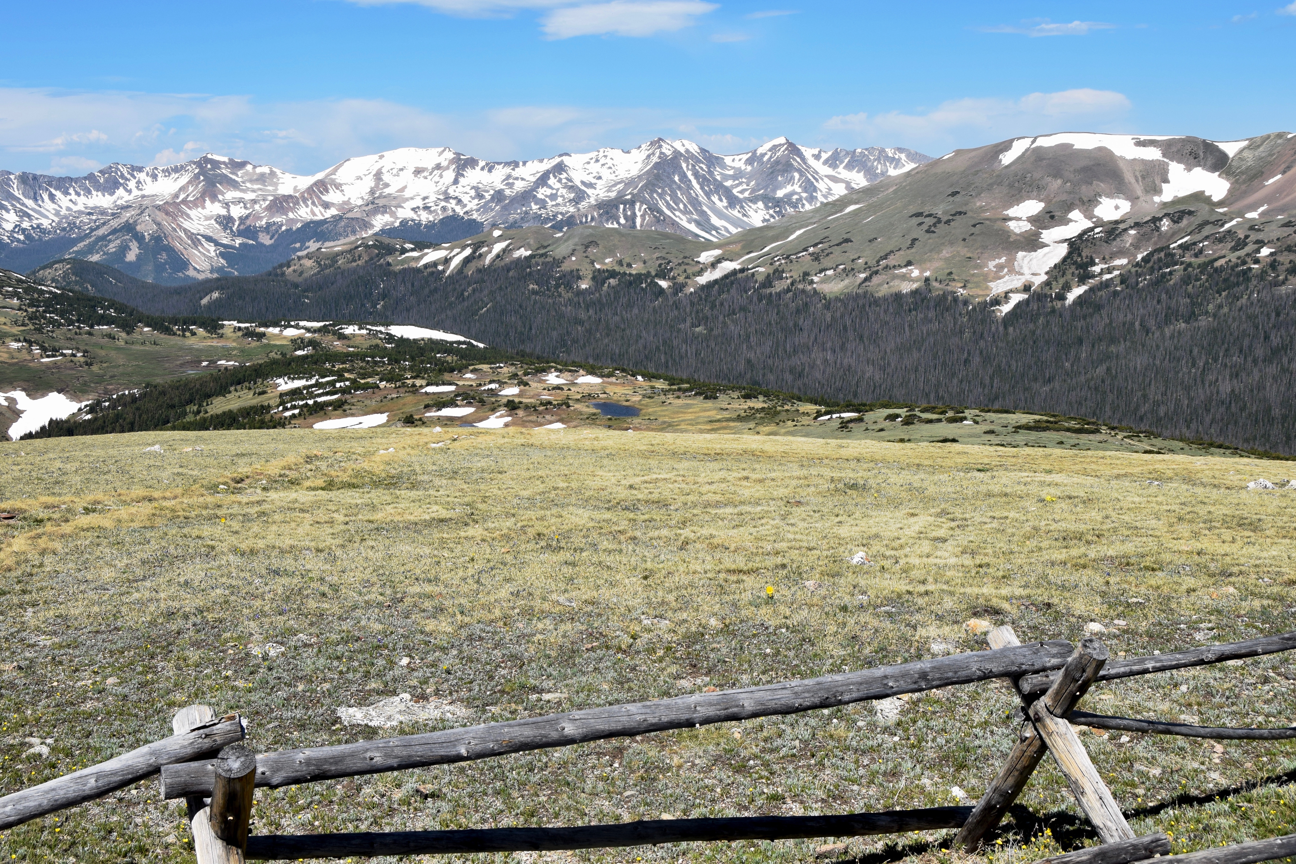
Looking south-west from Gore Range Overlook. Terrain and imagery at true elevation.

Gore Range Overlook sits at 12,032 feet on Trail Ridge Road/Beaver Meadow Road, facing 210 degrees, with the land dropping 678 feet within 600 meters of the pullout. The view takes in six named peaks to the west and south: Shipler Mountain at 11,300 feet, 3.6 miles west; Terra Tomah Mountain at 12,703 feet, 4.0 miles south-southeast; Mount Ida at 12,866 feet, 4.2 miles south; Mount Julian at 12,889 feet, 4.3 miles south; Chief Cheley Peak at 12,740 feet, 4.5 miles south; and Cracktop at 12,762 feet, 4.6 miles south. Daylight hours shift with the season, from a 07:24 sunrise and 16:40 sunset at the December solstice to a 05:34 sunrise and 20:38 sunset at the June solstice. The nearest towns are Fort Collins (37.9 miles east-northeast), Boulder (39.0 miles southeast), and Longmont (39.6 miles east-southeast). Medicine Bow Curve is the previous lookout along the route, with Lava Cliffs next. Trail Ridge Road closes from mid-October through Memorial Day and can be affected by sudden weather changes at this elevation.

Access
On the byway
Elevation
12,032 ft
View
Southwest · 210°
Relief
678 ft drop
In view
6 named features
View of Never Summer Mountains from Gore Range Overlook
NPS Photo / Karen Daugherty · Public domain (NPS) · NPS
Gore Range Overlook
Thomson M · CC BY 3.0 · source
View of the continental divide, near Estes Park, Colorado
Brylie Oxley · CC BY-SA 3.0 · source
Rocky Mountain National Park
Greg Willis from Denver, CO, usa · CC BY-SA 2.0 · source
Trail Ridge Road above Treeline, Rocky Mountain National Park - Photograph by Anne Dirkse, www.annedirkse.com
Anne Dirkse · CC BY-SA 4.0 · source
View from Alpine Visitor Center. May 25, 2008
Vadim Manuylov · CC BY-SA 3.0 · source

What you’re looking at

Named terrain inside the view from this overlook, nearest first.

  • Shipler Mountain11,300 ftwest · 3.6 mi
  • Terra Tomah Mountain12,703 ftsouth-southeast · 4.0 mi
  • Mount Ida12,866 ftsouth · 4.2 mi
  • Mount Julian12,889 ftsouth · 4.3 mi
  • Chief Cheley Peak12,740 ftsouth · 4.5 mi
  • Cracktop12,762 ftsouth · 4.6 mi

Light

DateSunriseSunsetGolden hour
March equinox07:0719:1518:39
June solstice05:3420:3819:56
September equinox06:5119:0218:26
December solstice07:2416:4015:57

Local time (America/Denver). Computed for this exact position.

Where it is

  • Fort Collins37.9 mi east-northeast
  • Boulder39.0 mi southeast
  • Longmont39.6 mi east-southeast
Loading map…
Private beta · Free to join

Take the scenic way to Gore Range Overlook.

Byway plans around your taste, verified places, real weather and opening hours — then opens every leg in Google Maps with one tap.

Private beta · Free to join · No card · Invite when a spot opens

Gore Range Overlook · National Park Service

Get spectacular views of Rocky Mountain National Park’s highest peaks!

Gore Range Overlook offers views of the Never Summer Mountains, and the Gore Range. From this western-facing pullout, the flat top of Long’s Peak is in sight - the highest peak at 14,259 feet in the park. The Never Summer Mountains were created by volcanic activity between 29 and 24 million years ago. The Arapaho Indians call these mountains Ni-chebe-chii, which translates to “Never No Summer”. The Gore Range is named after St. George Gore, an Irish aristocrat who visited the area in the mid 1800’s to lead an infamous hunting expedition.

Note: Trail Ridge Road closes mid-October to Memorial Day. Extreme weather can change the status of Trail Ridge Road at any time—be ready to adjust your travel plans if needed, and always check the weather before you start your drive.

Altitude Warning: Altitude sickness affects many visitors every year. Symptoms include headache, nausea, fatigue, dizziness, vomiting, and even unconsciousness. Altitude can also aggravate pre-existing conditions like heart and lung disease. Take your time, drink water, eat, and rest. The only cure for altitude sickness is to go down to a lower altitude.

Read it at National Park Service

Terra Tomah Mountain · WikipediaCC BY-SA

Terra Tomah Mountain is a 12,718-foot-elevation (3,876-meter) mountain summit located in Rocky Mountain National Park, in Larimer County, of Colorado, United States. It is situated 13 miles west of the community of Estes Park, and 1.5 mile east of the Continental Divide. Terra Tomah Mountain is part of the Front Range which is a subset of the Rocky Mountains. Topographic relief is significant as the northeast aspect rises 3,300 feet above Forest Canyon in 1.5 mile. It is a prominent landmark viewed from Forest Canyon Overlook along the Trail Ridge Road.

Read it at Wikipedia

How high is Gore Range Overlook?

Gore Range Overlook sits at about 12,032 feet (3,667 m).

What can you see from Gore Range Overlook?

From Gore Range Overlook: Shipler Mountain (W, 3.6 mi); Terra Tomah Mountain (SSE, 4.0 mi); Mount Ida (S, 4.2 mi); Mount Julian (S, 4.3 mi).

What is the nearest town to Gore Range Overlook?

Fort Collins, 38 miles ENE of Gore Range Overlook.

What is the next lookout after Gore Range Overlook?

Lava Cliffs is the next surfaced lookout along the same route after Gore Range Overlook.

Drive to Gore Range Overlook with Byway

Byway plans the scenic way there — real places along Trail Ridge Road/Beaver Meadow Road, real weather, zero hallucinations — and hands the turns to the navigation you already use.

Byways with this lookout

Day trips start here

Locals make it Verified.

Gore Range Overlook — confirmed, rated, and photographed by people who actually pulled over. A local confirmation is what upgrades a lookout from Discovered to Verified. Zero hallucinations.

Confirmed by locals

No local confirmations yet. Stood here? Yours is the one that upgrades this lookout to Verified.

Ratings

No ratings yet. Stood at this lookout? Be the first to rate it.

No written reviews yet.

Field notes

No field notes yet. Know the gate hours or the best pull-in? Leave the note you wish you'd had.

Photos

No photos yet.

Sign in to confirm this lookout, rate it, add photos, and leave field notes.

More lookouts on Trail Ridge Road/Beaver Meadow Road

Named places near this lookout