Skip to content

Lembert Dome

OpenStreetMap
Looking south-west from Lembert Dome. Terrain and imagery at true elevation.
Access
0.3 mi detour
Elevation
9,419 ft
View
Southwest · 210°
Relief
790 ft drop
In view
10 named features
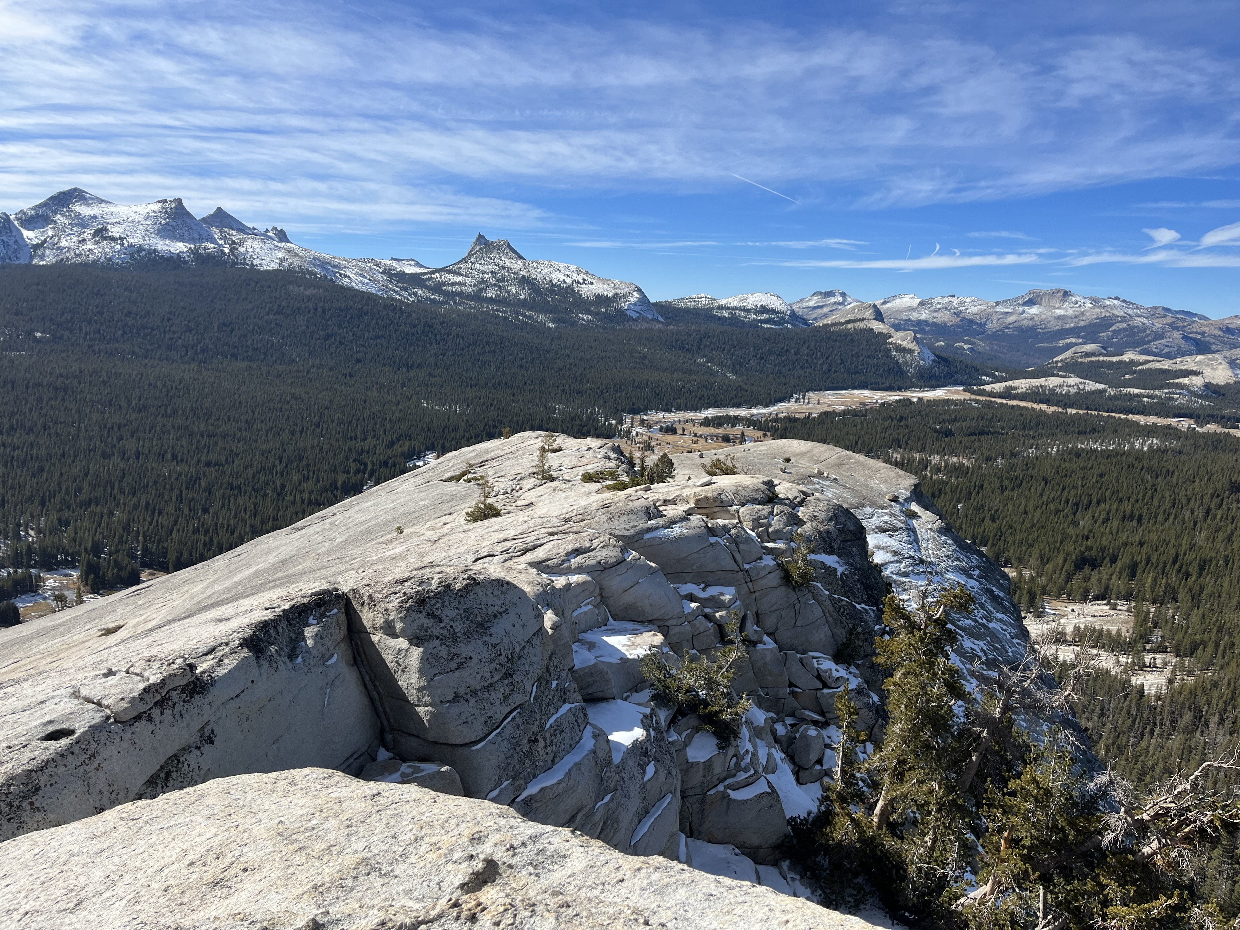
The summit of Lembert Dome in late fall looking toward the Cathedral Range
National Park Service · Public domain (NPS) · NPS
Junction of Lyell Fork and Dana Fork of Tuolumne River with Lembert Dome in the background at Tuolumne Meadows section of Yosemite National Park .
Jarek Tuszyński · CC BY 4.0 · source
Junction of Lyell Fork and Dana Fork of Tuolumne River with Lembert Dome in the background at Tuolumne Meadows section of Yosemite National Park .
Jarek Tuszyński · CC BY 4.0 · source
View from base of Lembert Dome
ogwen · CC BY-SA 3.0 · source
View from base of Lembert Dome
ogwen · CC BY-SA 3.0 · source
View from base of Lembert Dome
ogwen · CC BY-SA 3.0 · source

What you’re looking at

Named terrain inside the view from this overlook, nearest first.

  • Pothole Dome8,783 ftwest · 2.6 mi
  • Marmot Dome9,247 ftwest · 2.8 mi
  • Unicorn Peak10,795 ftsouthwest · 3.2 mi
  • Fairview Dome9,711 ftwest-southwest · 3.2 mi
  • Johnson Peak11,058 ftsouth · 3.2 mi
  • Daff Dome9,163 ftwest · 3.6 mi
  • Cathedral Peak10,845 ftsouthwest · 4.0 mi
  • Eichorn Pinnacle10,776 ftsouthwest · 4.0 mi
  • Drug Dome9,348 ftwest-southwest · 4.3 mi
  • Lamb Dome9,205 ftwest-southwest · 4.3 mi

Light

DateSunriseSunsetGolden hour
March equinox07:0219:1018:35
June solstice05:3620:2419:44
September equinox06:4618:5618:21
December solstice07:1016:4216:01

Local time (America/Los_Angeles). Computed for this exact position.

Where it is

  • June Lake16.4 mi east-southeast
  • Mammoth Lakes26.5 mi southeast
  • Crowley Lake39.5 mi east-southeast
Loading map…
Private beta · Free to join

Take the scenic way to Lembert Dome.

Byway plans around your taste, verified places, real weather and opening hours — then opens every leg in Google Maps with one tap.

Private beta · Free to join · No card · Invite when a spot opens

Lembert Dome and Dog Lake Trailhead · National Park Service

Beginning from the north end of Dog Lake parking, the trail climbs through the forest to Dog Lake, then take a spur to the summit of Lembert Dome. There is no marked trail on the bare rock on Lembert Dome; choose the easiest path to the summit for panoramic views of Tuolumne Meadows and the surrounding peaks. Lembert Dome is an example of a roche moutonnée, a glacial landform with an asymmetrical shape. The steep western face and gradual eastern slope indicate the direction of glacial flow when glaciers filled Tuolumne Meadows. Dog Lake is a quiet, forested lake that is home to many species including water birds, song birds, deer, and dragonflies. Distance: 3.8 miles (6.1 km) round-trip Elevation gain: 850 ft (260 m) elevation gain Time estimate: 3-4 hours Route variation: return via Lembert Dome Parking for a 5-mile loop. Or, hike this route as an out-and-back beginning from Lembert Dome Parking instead of Dog Lake Parking, a slightly longer route to the same destinations.

Tips & Seasonal Information Stay off domes during thunderstorms! Despite its name, pets are not allowed at Dog Lake or any other hiking trails. This trailhead is only reachable by vehicle when Tioga Road is open, typically late May or early June to sometime in October or November. Tioga Road closes after the first significant snowfall. Overnight parking on this road, including this trailhead, ends October 15. For current road and weather information, please call 209/372-0200 (press 1, then 1).

Read it at National Park Service

Pothole Dome · WikipediaCC BY-SA

Pothole Dome is a granite dome on the west side of Tuolumne Meadows, in Yosemite National Park located at Tioga Road mile marker 18. Near Pothole Dome is Marmot Dome. The summit of the dome is easily accessible by foot from a parking area on the Tioga Road at mile marker 18. The view from the summit includes most of Tuolumne Meadows and in the distance, Cathedral Peak. The dome gives evidence of many of the geologic processes at work in Yosemite during and after the last ice age. In particular, the stranded, rounded boulders from a glacier that has long since retreated, and the water-eroded "potholes" provide evidence of two ways that water can interact with granite.

Read it at Wikipedia

WikipediaCC BY-SA

Lembert Dome is a granite dome rock formation in Yosemite National Park in the US state of California. The dome soars 800 feet (240 m) above Tuolumne Meadows and the Tuolumne River and can be hiked starting at the Tioga Road in the heart of Tuolumne Meadows, 8 miles (13 km) west of the Tioga Pass Entrance to Yosemite National Park. The landform is an example of a rôche moutonnée with clear lee and stoss slopes.

Read it at Wikipedia

How high is Lembert Dome?

Lembert Dome sits at about 9,419 feet (2,871 m).

What can you see from Lembert Dome?

From Lembert Dome: Pothole Dome (W, 2.6 mi); Marmot Dome (W, 2.8 mi); Unicorn Peak (SW, 3.2 mi); Fairview Dome (WSW, 3.2 mi).

What is the nearest town to Lembert Dome?

June Lake, 16 miles ESE of Lembert Dome.

Drive to Lembert Dome with Byway

Byway plans the scenic way there — real places along Tioga Road/Big Oak Flat Road, real weather, zero hallucinations — and hands the turns to the navigation you already use.

Byways with this lookout

Day trips start here

Locals make it Verified.

Lembert Dome — confirmed, rated, and photographed by people who actually pulled over. A local confirmation is what upgrades a lookout from Discovered to Verified. Zero hallucinations.

Confirmed by locals

No local confirmations yet. Stood here? Yours is the one that upgrades this lookout to Verified.

Ratings

No ratings yet. Stood at this lookout? Be the first to rate it.

No written reviews yet.

Field notes

No field notes yet. Know the gate hours or the best pull-in? Leave the note you wish you'd had.

Photos

No photos yet.

Sign in to confirm this lookout, rate it, add photos, and leave field notes.

More lookouts on Tioga Road/Big Oak Flat Road

Named places near this lookout