Santa Rosa Island Visitor Contact Station
34.0075, -120.0506 · Park boundary: National Park Service
Take the scenic way to Santa Rosa Island Visitor Contact Station.
Byway plans around your taste, verified places, real weather and opening hours — then opens every leg in Google Maps with one tap.
The historic schoolhouse is now home to this small visitor contact station with exhibits on the ranching history of Santa Rosa Island.
- Every day
- 8:30AM - 5:00PM
The visitor contact station is open 8:30 am until 5 pm daily.
Santa Rosa Island Visitor Contact Station is a Passport To Your National Parks stamp location.
This visitor center can only be visited by boat. Book your transportation with the park concessioner.
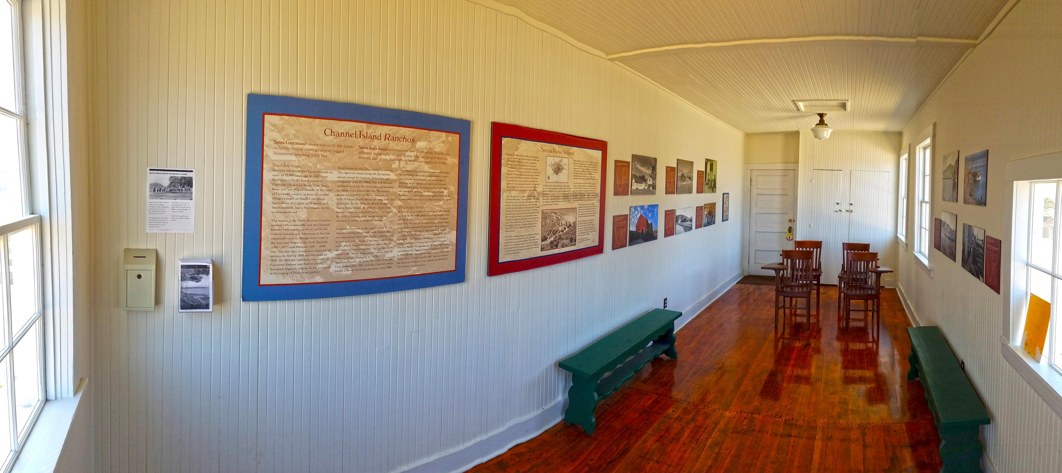
Standing in the doorway of the school house facing inward, the interior is about 16 feet long and 8 feet wide. The walls and ceiling are finished with narrow vertical wooden slat paneling, painted white. The ceiling has a framed inset panel, to access the attic, and a white ceramic ceiling lamp, with a brass mount. The wooden plank floor has a glossy polish. Moving into the room, along the left wall, you will find a framed window with thin wooden mullions containing 12 glass panes; a mounted metal box; a clear plastic pamphlet holder; an information panel; two larger exhibit panels with a low wooden green bench below them; six exhibits with large photographs; and a wall plaque that reads,AcknowledgementsImages of Santa Cruz Island, Santa Rosa Island and Nuestra Senora del RefugioCommemorating Early Land Grants on Both Sides of the ChannelAn exhibition organized by the Santa Barbara Trust for Historic PreservationExhibition Sponsors: The Henry W. Bull FoundationCurators: Carol Storke, Anne Petersen, Curator. SBTHPCuratorial Assistant: Amanda WillifordPhotography and Printing: William B. DeweyGraphic Design: Mary KirkPatrick, Clearview StudioPrint Mounting: Ken KirkPatrick, Anacapa SignsSpecial Thanks:Chris Chapman, Manager, Arroyo Hondo Preserve; Peggy Dahl, Santa Cruz Island Foundation; Marla Daily, President, Santa Cruz Island Foundation; Neal Graffy, Elizabeth Hvolboll, Michael Redmon, Archivist, Santa Barbara Historical Society; Terri Sheridan, Archivist, Santa Barbara Museum of Natural History; Nita Vail, Executive Director, California Rangeland Trust; Kim Walters, Archivist, Southwest Museum; Lynn Weber, Curatorial Volunteer, SBTHP. Will Woolley and the staff, board and many volunteers at the Santa Barbara Trust for Historic Preservation. On the lower right corner of the plaque is the Seal of the Santa Barbara Trust Historic Preservation, a round logo, with a center illustration of an early adobe brick Spanish mission building, with a bell tower with a cross on top.Along the back wall is wooden door, and also two tall closet doors.Along the right wall, from back to front, are two windows; four exhibits with large photos; and another window with a green wooden bench below it.On the floor near the back of the room, are four wooden chairs, arranged in two rows, both facing the front door. Each has a single arm rest that extends and curves out to become a wide flat panel, parallel to the floor. The two chairs have this arm rest panel on the right "arm," and the other two have it on the left "arm."An information panel, titled "Santa Rosa Island Interpretive Guide," is posted on the wall inside the School House.The panel background is a black and white photo showing twelve people on horseback, in front of a wooden fence. Behind it is a thick section of trees. In the distance, to the left, is a large hill.The text reads,Learn more about ranch history, including a complete map and guide to the ranch area, in the Santa Rosa Island Interpretive Guide.The guide also provides detailed information on island Chumash history, military history, and natural history. In addition, it serves as a trail guide for the 1.75 mile hike from the pier to Water Canyon Beach via Cherry Canyon.Borrow the guide and return it or take it home and donate at ciparkfoundation.org/join-support/.Below and to the left of this panel is a small metal box with a locked panel in front, and a slanted top with a slit in the center, about three inches wide. To the right of this box is a wall mounted plastic holder that contains the guides. This exhibit panel, titled "Channel Island Ranchos," provides cultural history about Santa Cruz Island and Santa Rosa Island.The panel background is a faded sepia photo, in shades of brown. It shows a steep, rocky shoreline, with a wooden staircase rising from the beach to the rocky plateau above. On the plateau are a large, long building, two smaller buildings, and canvas tents. The text reads:Santa Cruz Island covers almost 61,000 acres, its fertile central valley girded by rugged mountains, reaching 2,434 feet.Santa Rosa Island encompasses over 54,000 acres, of strikingly different topography - rolling grassy hills, mesas with deep-cut arroyos, and dunes that shift in the almost continuous winds.The Early Years.Humans inhabited the Channel Islands as early as 12,000 years ago. In 1542, Juan Rodriguez Cabrillo found populous Chumash villages on Santa Cruz, Santa Rosa, and San Miguel islands. The waters of the Santa Barbara Channel teemed with marine life, and the Channel Islands were regular ports of call for fur traders, hunters, and fishermen in the late eighteenth century, although most trade was illegal under both Spanish (1769 to 1821) and Mexican (1821 to 1848) rule. The sea otter population experienced a serious decline by 1820 and the seals by 1830. By 1810 the islanders, victimized by European disease and their economy disrupted, began to migrate to the mainland at the urging of Franciscan padres.
Location, hours, and facility details confirmed against the National Park Service registry.
National Park Service registryChecked 2026-08-04
Where is Santa Rosa Island Visitor Contact Station?
Santa Rosa Island Visitor Contact Station in Channel Islands National Park is at Santa Rosa Island Visitor Contact Station, Ventura, CA.
What services does Santa Rosa Island Visitor Contact Station offer?
Santa Rosa Island Visitor Contact Station in Channel Islands National Park lists animal-safe food storage, audio description, benches/seating, first aid kit available, historical/interpretive information/exhibits, information, information - maps available, picnic table, scenic view/photo spot.
Is there a passport stamp at Santa Rosa Island Visitor Contact Station?
Yes. Santa Rosa Island Visitor Contact Station in Channel Islands National Park is a National Park Passport stamp location.
What is the phone number for Santa Rosa Island Visitor Contact Station?
Santa Rosa Island Visitor Contact Station in Channel Islands National Park can be reached on 805-658-5730.
- Channel Islands National Park Visitor CenterPassport stamp
- Outdoors Santa Barbara Visitor Center
- San Miguel Island Ranger and Visitor Contact StationPassport stamp
- Santa Barbara Island Visitor CenterPassport stamp
- Scorpion Ranch Visitor Center on Santa Cruz IslandPassport stamp
- Visitor Center Anacapa IslandPassport stamp
Drive to Santa Rosa Island Visitor Contact Station
Byway plans the scenic way in — real places, real weather, every stop verified. Zero hallucinations. Google Maps for turns. Byway for soul.