Skip to content

Browning Knob Overlook

VerifiedOpenStreetMap + National Park Service
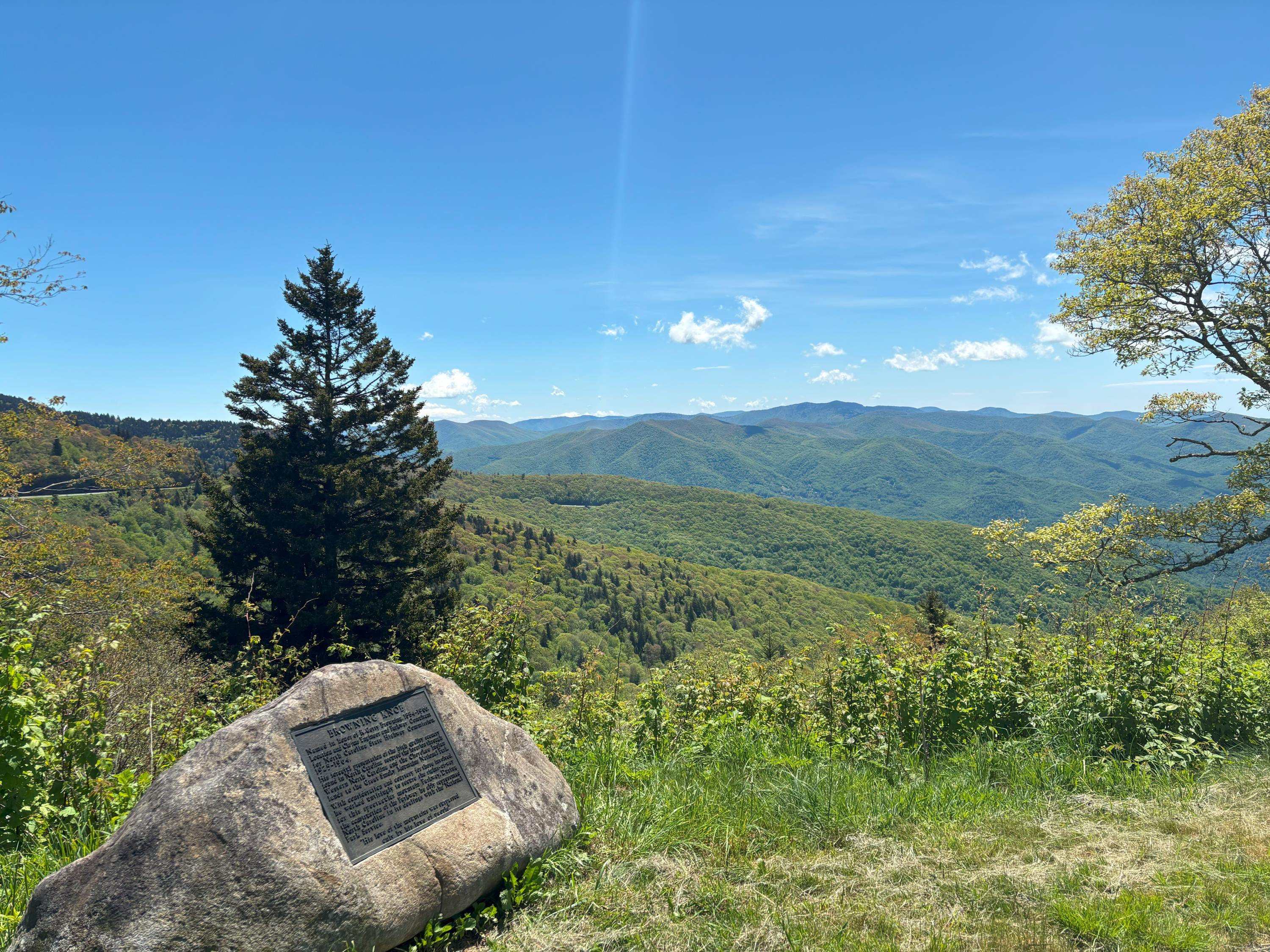
Looking east from Browning Knob Overlook. Terrain and imagery at true elevation.

Browning Knob Overlook sits on the entry road to the Waterrock Knob Visitor Center at milepost 451.2, at an elevation of 5,719 feet, facing east. The land drops 968 feet within 600 meters of the overlook. A plaque at the site commemorates R. Getty Browning, the Federal Parkway Engineer and Senior Locating and Claim Engineer for the Blue Ridge Parkway, whose work guided the initial exploration and design of the parkway; the knob and overlook are named in his honor. From the overlook, Yellow Face Overlook is visible to the east at 0.6 miles, Scott Creek Overlook to the east-southeast at 1.4 miles, Wesner Bald Overlook to the east-southeast at 1.6 miles, and Mount Lyn Lowry to the east-northeast at 1.7 miles, rising to 6,229 feet. The facing direction looks toward sunrise. Waynesville is 8.8 miles to the east-northeast, with Asheville further out in the same direction at 34.5 miles, and Sevierville 37.0 miles to the northwest. The area is often closed in winter due to ice and snow, so checking road status before traveling is recommended. Pedestrian Overlook precedes this stop, and Waterrock Knob Viewpoint and Trail follows.

Access
On the byway
Elevation
5,719 ft
View
East · 90°
Light
Best at sunrise
Relief
968 ft drop
In view
4 named features
View from the Browning Knob Overlook
NPS Photo/ A.Danneker · Public domain (NPS) · NPS
WaterRock Knob Smoky Mts. NP Maggie Valley
pseabolt · CC BY 3.0 · source
Waterrock Knob Blue Ridge Parkway
Pete Seabolt · CC BY 3.0 · source
Blue Ridge Parkway
hakkun · CC BY-SA 3.0 · source
view from trail
Dsdugan · CC0 · source
blue ridge parkway
Dsdugan · CC0 · source

What you’re looking at

Named terrain inside the view from this overlook, nearest first.

  • Yellow Face Overlook (MP 450.2)5,734 fteast · 0.6 mi
  • Scott Creek Overlook (MP 448.5)5,158 fteast-southeast · 1.4 mi
  • Wesner Bald Overlook (MP 448.1)4,990 fteast-southeast · 1.6 mi
  • Mount Lyn Lowry6,229 fteast-northeast · 1.7 mi

Light

This overlook faces sunrise 0° off square to it.

DateSunriseSunsetGolden hour
March equinox07:3719:4519:11
June solstice06:1820:5220:14
September equinox07:2119:3118:57
December solstice07:3917:2416:45

Local time (America/New_York). Computed for this exact position.

Where it is

  • Waynesville8.8 mi east-northeast
  • Asheville34.5 mi east-northeast
  • Sevierville37.0 mi northwest
Loading map…
Private beta · Free to join

Take the scenic way to Browning Knob Overlook.

Byway plans around your taste, verified places, real weather and opening hours — then opens every leg in Google Maps with one tap.

Private beta · Free to join · No card · Invite when a spot opens

Browning Knob Overlook · National Park Service

Browning Knob Overlook is on the entry road to the Waterrock Knob Visitor Center at milepost 451.2. The area is often closed in winter due to ice and snow. Check out our Road Status and Closures webpage before you travel to this location. The overlook is at an elevation of 5770 feet looking towards Browning Knob which is 6260 feet of elevation. The knob and the overlook were named in honor of R. Getty Browning. Browning was the Federal Parkway Engineer and the Senior Locating and Claim Engineer for the Blue Ridge Parkway. It was his work that guided the initial exploration and design of the parkway. Also at this location is a plaque commemorating Mr. Browning and Browning Knob. It reads as follows: BROWNING KNOB Named in honor of R. Getty Browning, 1884-1966, Location and Claims Engineer and Parkway Consultant For North Carolina State Highway Commission, 1925-1964. His forceful presentation of the high quality scenery Found in North Carolina secured the location through  Western North Carolina and the Cherokee Indian Lands to the Great Smoky Mountains National Park. With consideration and courtesy for those involved, He worked untiringly to secure the rights-of-way For this spectacular mountain Parkway. During The construction of the Parkway he ably represented North Carolina in its dealings with the National Park Service. “His love of the mountains was surpassed only by his love of people.”

Read it at National Park Service

How high is Browning Knob Overlook?

Browning Knob Overlook sits at about 5,719 feet (1,743 m).

What can you see from Browning Knob Overlook?

From Browning Knob Overlook: Yellow Face Overlook (MP 450.2) (E, 0.6 mi); Scott Creek Overlook (MP 448.5) (ESE, 1.4 mi); Wesner Bald Overlook (MP 448.1) (ESE, 1.6 mi); Mount Lyn Lowry (ENE, 1.7 mi).

Is Browning Knob Overlook better at sunrise or sunset?

Sunrise. The land falls away from Browning Knob Overlook toward the sunrise, so at sunset the light is behind you. Exact times shift through the year; the page shows the current window.

What is the nearest town to Browning Knob Overlook?

Waynesville, 8.8 miles ENE of Browning Knob Overlook.

What is the next lookout after Browning Knob Overlook?

Waterrock Knob Viewpoint and Trail is the next surfaced lookout along the same route after Browning Knob Overlook.

Drive to Browning Knob Overlook with Byway

Byway plans the scenic way there — real places along Blue Ridge Parkway, real weather, zero hallucinations — and hands the turns to the navigation you already use.

Byways with this lookout

Locals make it Verified.

Browning Knob Overlook — confirmed, rated, and photographed by people who actually pulled over. A local confirmation is what upgrades a lookout from Discovered to Verified. Zero hallucinations.

Confirmed by locals

No local confirmations yet. Stood here? Yours is the one that upgrades this lookout to Verified.

Ratings

No ratings yet. Stood at this lookout? Be the first to rate it.

No written reviews yet.

Field notes

No field notes yet. Know the gate hours or the best pull-in? Leave the note you wish you'd had.

Photos

No photos yet.

Sign in to confirm this lookout, rate it, add photos, and leave field notes.

More lookouts on Blue Ridge Parkway

Named places near this lookout