Skip to content

Glassmine Falls Overlook

VerifiedOpenStreetMap + National Park Service
Looking south-east from Glassmine Falls Overlook. Terrain and imagery at true elevation.

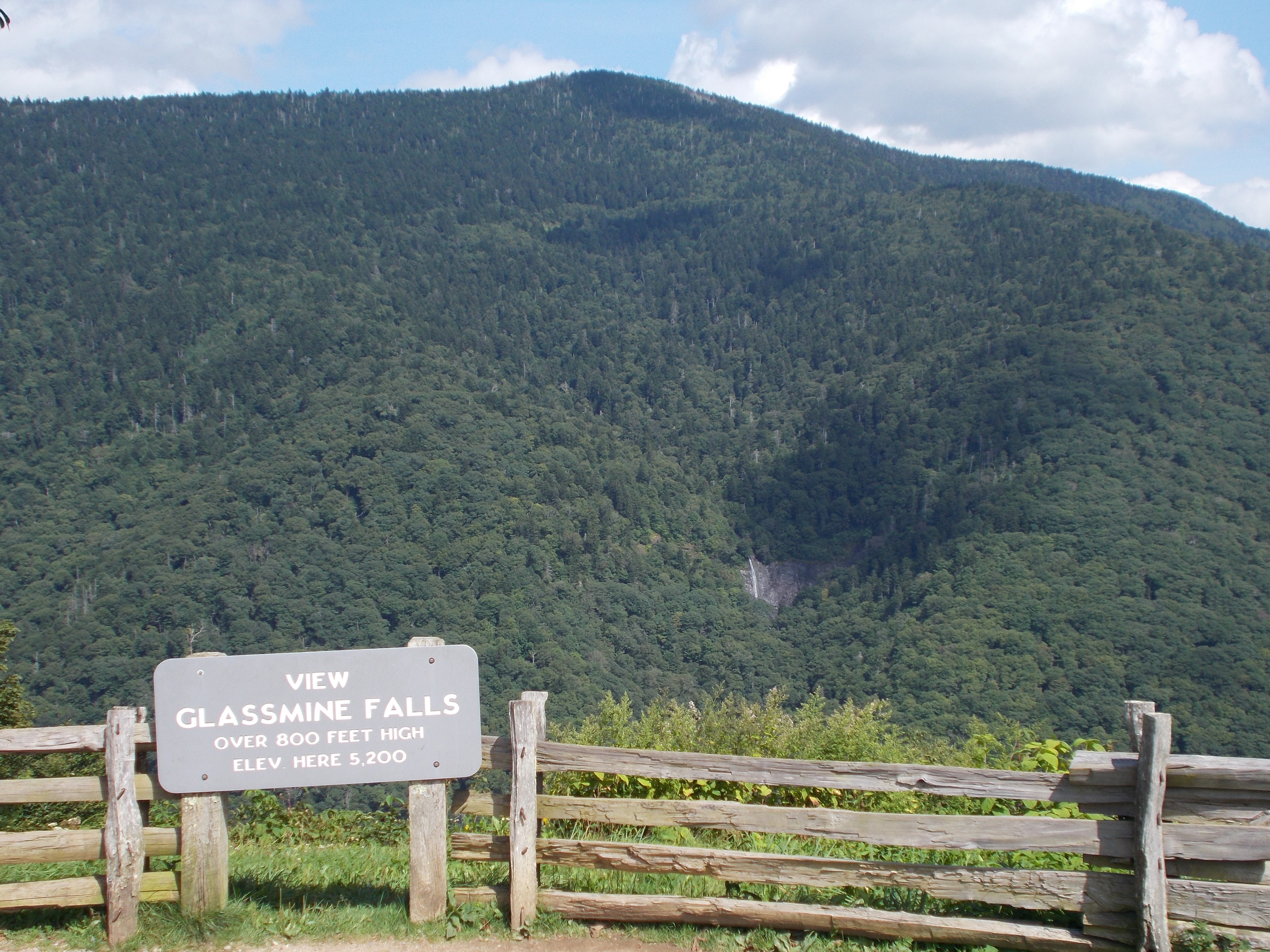
Glassmine Falls Overlook sits at 5,200 feet on the Blue Ridge Parkway, facing 120 degrees toward the east-southeast. The land drops 954 feet within 600 meters of the overlook. Glassmine Falls is visible to the east at 0.7 miles, an ephemeral waterfall that flows after rain and can slow to a trickle or dry up during drier periods; an old mica mine sits at its base, on land now part of the Asheville watershed with no public access to the falls itself. Blackstock Knob rises to the east at 1.5 miles, with Bald Knob, Pinnacle, Graybeard Mountain, and Greybeard Peak visible to the east-southeast and southeast between 4.0 and 4.4 miles. A short path from the overlook leads to another viewing area, and the Mountains-to-Sea Trail can be accessed from either end of the overlook. The facing direction looks toward sunrise, with sunrise times ranging from 06:14 at the June solstice to 07:36 at the December solstice. Asheville lies 15.1 miles to the southwest, Morganton 36.8 miles east, and Boone 49.8 miles northeast. Graybeard Mountain View is the previous lookout along the route, with Walker Knob Overlook next.

Access
On the byway
Elevation
5,200 ft
View
Southeast · 120°
Light
Best at sunrise
Relief
954 ft drop
In view
6 named features
View of waterfall from Glassmine Falls Overlook
NPS Photo / Gail Fox · Public domain (NPS) · NPS
View from Blue Ridge Parkway
Will Thomas · CC BY-SA 3.0 · source
mountain wood aster ( Eurybia chlorolepis )
Ken Kneidel · CC0 · source
The flowers and leaves of Angelica triquinata, observed near Balsam Gap, Black Mountain, North Carolina
Ken Kneidel · CC0 · source
Waterfall on Lower Staire Branch in the Big Ivy/Coleman Boundary area of Pisgah National Forest
Honeybadgerhiking · CC BY-SA 4.0 · source

What you’re looking at

Named terrain inside the view from this overlook, nearest first.

  • Glassmine Falls4,888 fteast · 0.7 mi
  • Blackstock Knob6,320 fteast · 1.5 mi
  • Bald Knob5,359 fteast-southeast · 4.0 mi
  • Pinnacle5,651 fteast-southeast · 4.4 mi
  • Graybeard Mountain5,398 ftsoutheast · 4.4 mi
  • Greybeard Peak5,398 ftsoutheast · 4.4 mi

Light

This overlook faces sunrise 30° off square to it.

DateSunriseSunsetGolden hour
March equinox07:3419:4119:08
June solstice06:1420:4920:11
September equinox07:1819:2818:54
December solstice07:3617:2016:41

Local time (America/New_York). Computed for this exact position.

Where it is

  • Asheville15.1 mi southwest
  • Morganton36.8 mi east
  • Boone49.8 mi northeast
Loading map…
Private beta · Free to join

Take the scenic way to Glassmine Falls Overlook.

Byway plans around your taste, verified places, real weather and opening hours — then opens every leg in Google Maps with one tap.

Private beta · Free to join · No card · Invite when a spot opens

Glassmine Falls Overlook · National Park Service

The attraction of Glassmine Falls Overlook is a tall, skinny waterfall that can be seen in the distance across the valley from the overlook. Seeing the waterfall requires a bit of luck, however, as this ephemeral falls only flows after periods of rain. During drier weather it will slow to a trickle or even dry up completely. So plan your visit after a rainy day, if you have that option! At the base of the waterfall is an old mica mine. Miners called the flaky, shiny mineral they mined “glass,” hence the name Glassmine Falls. There were many “glass mines” that operated in western North Carolina in the early 1900s. Today the waterfall and surrounding land is privately owned as part of the Asheville watershed. There is no public access to the waterfall. But the view from the overlook after a good rain is impressive—even better if you bring a pair of binoculars. And listen closely, you may even hear the distant sounds of this roaring cascade as it plummets over the steep cliff. The sign at the overlook says the falls is over 800 feet high. That seems to be extremely generous—most would estimate around 200 feet—but Glassmine Falls is a magnificent sight, nonetheless. A short path from the overlook leads to another viewing area. The Mountains-to-Sea Trail can be accessed from either end of the overlook. Check the conditions of the area before you visit.

Read it at National Park Service

How high is Glassmine Falls Overlook?

Glassmine Falls Overlook sits at about 5,200 feet (1,585 m).

What can you see from Glassmine Falls Overlook?

From Glassmine Falls Overlook: Glassmine Falls (E, 0.7 mi); Blackstock Knob (E, 1.5 mi); Bald Knob (ESE, 4.0 mi); Pinnacle (ESE, 4.4 mi).

Is Glassmine Falls Overlook better at sunrise or sunset?

Sunrise. The land falls away from Glassmine Falls Overlook toward the sunrise, so at sunset the light is behind you. Exact times shift through the year; the page shows the current window.

What is the nearest town to Glassmine Falls Overlook?

Asheville, 15 miles SW of Glassmine Falls Overlook.

What is the next lookout after Glassmine Falls Overlook?

Walker Knob Overlook is the next surfaced lookout along the same route after Glassmine Falls Overlook.

Drive to Glassmine Falls Overlook with Byway

Byway plans the scenic way there — real places along Blue Ridge Parkway, real weather, zero hallucinations — and hands the turns to the navigation you already use.

Byways with this lookout

Day trips start here

Locals make it Verified.

Glassmine Falls Overlook — confirmed, rated, and photographed by people who actually pulled over. A local confirmation is what upgrades a lookout from Discovered to Verified. Zero hallucinations.

Confirmed by locals

No local confirmations yet. Stood here? Yours is the one that upgrades this lookout to Verified.

Ratings

No ratings yet. Stood at this lookout? Be the first to rate it.

No written reviews yet.

Field notes

No field notes yet. Know the gate hours or the best pull-in? Leave the note you wish you'd had.

Photos

No photos yet.

Sign in to confirm this lookout, rate it, add photos, and leave field notes.

More lookouts on Blue Ridge Parkway

Named places near this lookout