Skip to content

Old Soaker Overlook

National Park Service
Old Soaker Overlook — direction of view not recorded. Terrain and imagery at true elevation.

Old Soaker Overlook sits at 23 feet elevation along the Acadia Scenic Byway, with the land dropping 25 feet within 600 meters of the site. The overlook takes its name from a rock ledge visible offshore, roughly halfway across the cove, which caused the wreck of the Schooner Tay. This ledge, along with the two headlands flanking it, blocks heavy Atlantic waves from carrying sand away from nearby Sand Beach. Several coastal features and peaks are visible from this point: Thunder Hole lies 0.6 miles southwest, Cadillac Cliffs 0.7 miles west-southwest, The Beehive 0.7 miles northwest, Gorham Mountain 0.7 miles west, Halfway Mountain 0.9 miles northwest, Boulder Beach 1.0 mile southwest, and the Otter Cliffs formations 1.1 to 1.2 miles south-southwest. The Gulf of Maine waters here are cold and oxygen-rich, supporting lobsters, urchins, and fish, which in turn draw predators such as ospreys, cormorants, seals, porpoises, and sharks. Ellsworth is 19.2 miles northwest; Bangor and Brewer lie roughly 43 to 44 miles northwest. This overlook follows Beehive Overlook and precedes Sunset view along the byway.

Access
0.4 mi detour
Elevation
23 ft
Relief
25 ft drop
In view
9 named features
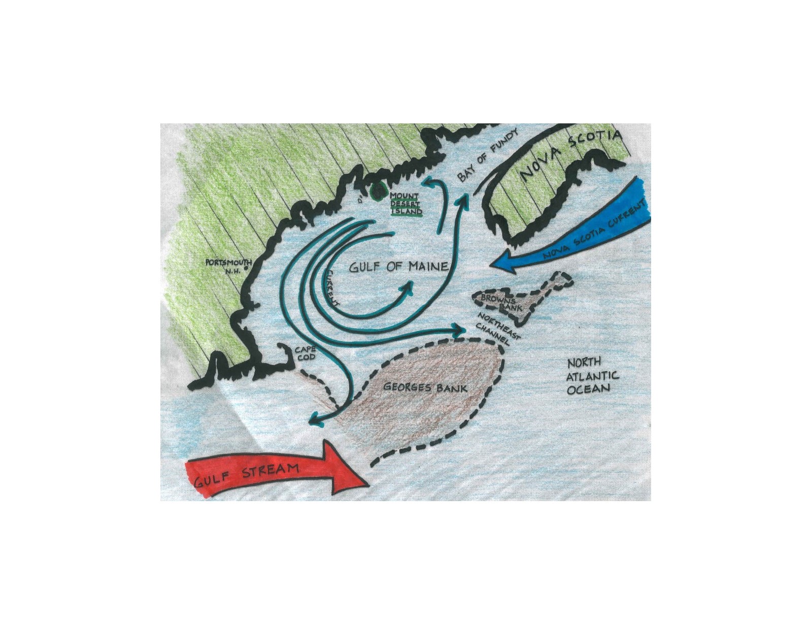
Offshore landforms like Georges Bank help trap cool water in the Gulf of Maine.
NPS Photo · Public domain (NPS) · NPS
The Beehive, Champlain Mountain, and Sand Beach from Great Head in Acadia National Park, Maine
Fredlyfish4 · CC BY-SA 4.0 · source
View east-southeast from the middle of Sand Beach within Acadia National Park in Bar Harbor, Hancock County, Maine
Famartin · CC BY-SA 4.0 · source
Acadia National Park
Always Shooting · CC BY 2.0 · source
Méditerranée ? Non Acadia park, ME
Eric Salard · CC BY-SA 2.0 · source
Newport Cove and the Beehive from Great Head in Acadia National Park, Maine
Fredlyfish4 · CC BY-SA 4.0 · source

What you’re looking at

Named terrain around this overlook, nearest first. No view direction is recorded, so every bearing is listed.

  • Thunder Hole59 ftsouthwest · 0.6 mi
  • Cadillac Cliffs396 ftwest-southwest · 0.7 mi
  • The Beehive528 ftnorthwest · 0.7 mi
  • Gorham Mountain508 ftwest · 0.7 mi
  • Halfway Mountain489 ftnorthwest · 0.9 mi
  • Boulder Beach58 ftsouthwest · 1.0 mi
  • Otter Cliffs119 ftsouth-southwest · 1.1 mi
  • Otter Cliffs Rock Climbing119 ftsouth-southwest · 1.1 mi
  • Otter Cliff137 ftsouth-southwest · 1.2 mi

Light

DateSunriseSunsetGolden hour
March equinox06:3718:4518:07
June solstice04:4920:2119:37
September equinox06:2018:3217:54
December solstice07:0615:5715:09

Local time (America/New_York). Computed for this exact position.

Where it is

  • Ellsworth19.2 mi northwest
  • Brewer43.4 mi northwest
  • Bangor44.0 mi northwest
Loading map…
Private beta · Free to join

Take the scenic way to Old Soaker Overlook.

Byway plans around your taste, verified places, real weather and opening hours — then opens every leg in Google Maps with one tap.

Private beta · Free to join · No card · Invite when a spot opens

Old Soaker Overlook · National Park Service

The Gulf of Maine is an extremely productive body of water, and many creatures call it home. Part of the reason why it is so productive is because it’s so cold. Colder water can hold more oxygen, and that oxygen gives life to many marine animals like lobsters, urchins, fish, and many more. Because these waters are filled to the brim with these critters, many marine predators also come to the Gulf of Maine for the abundance of food. Predators like Ospreys, Double-crested Cormorants, seals, porpoises, and even sharks can be found in the waters around Acadia. Look out into the ocean here, about halfway across the cove: do you see a rock ledge? This rock is known as Old Soaker, the same ledge that caused the demise of the Schooner Tay. Old Soaker, along with the two headlands that surround it, all help to protect the sand on Sand Beach from the heavy waves of the Atlantic. Without protection from Old Soaker, the sand could be easily carried away from the beach by strong waves. Sand Beach is a unique beach in Maine. It is mostly composed of tiny pieces of broken shells. It is unusual to see a shell beach in an area with such cold water – shells are made of calcium carbonate, which dissolves easily in cold water. Beaches like these are much more common in warmer parts of the world like the Carolinas or Florida, where the water isn’t cold enough to rapidly dissolve shells. The shell-fragment sand of Sand Beach is a testament to how productive the waters of Maine are: the cold, oxygen-rich water produces more shelled creatures than it can dissolve, making Sand Beach possible.

Read it at National Park Service

How high is Old Soaker Overlook?

Old Soaker Overlook sits at about 23 feet (7 m).

What can you see from Old Soaker Overlook?

From Old Soaker Overlook: Thunder Hole (SW, 0.6 mi); Cadillac Cliffs (WSW, 0.7 mi); The Beehive (NW, 0.7 mi); Gorham Mountain (W, 0.7 mi).

What is the nearest town to Old Soaker Overlook?

Ellsworth, 19 miles NW of Old Soaker Overlook.

What is the next lookout after Old Soaker Overlook?

Sunset view is the next surfaced lookout along the same route after Old Soaker Overlook.

Drive to Old Soaker Overlook with Byway

Byway plans the scenic way there — real places along Acadia Scenic Byway, real weather, zero hallucinations — and hands the turns to the navigation you already use.

Byways with this lookout

Day trips start here

Locals make it Verified.

Old Soaker Overlook — confirmed, rated, and photographed by people who actually pulled over. A local confirmation is what upgrades a lookout from Discovered to Verified. Zero hallucinations.

Confirmed by locals

No local confirmations yet. Stood here? Yours is the one that upgrades this lookout to Verified.

Ratings

No ratings yet. Stood at this lookout? Be the first to rate it.

No written reviews yet.

Field notes

No field notes yet. Know the gate hours or the best pull-in? Leave the note you wish you'd had.

Photos

No photos yet.

Sign in to confirm this lookout, rate it, add photos, and leave field notes.

More lookouts on Acadia Scenic Byway

Named places near this lookout