Skip to content

Otto's Trail

OpenStreetMap
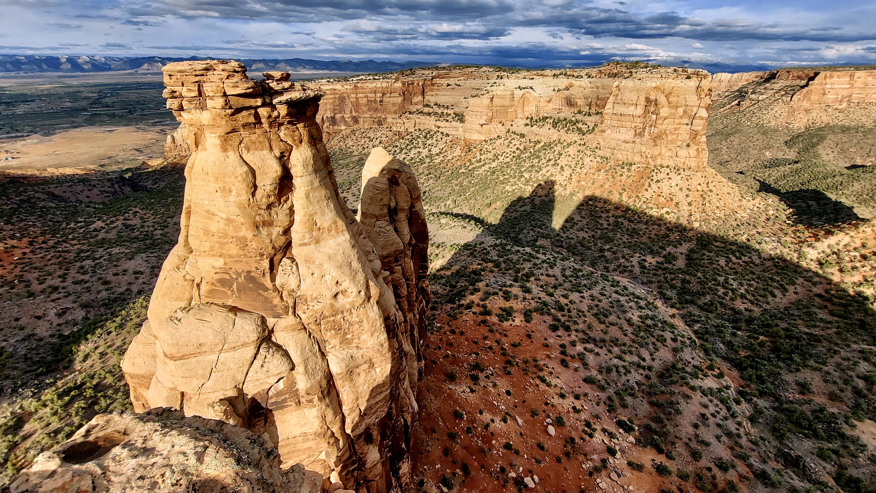
Looking north-east from Otto's Trail. Terrain and imagery at true elevation.

Otto's Trail sits along the Dinosaur Diamond byway at 5,696 feet, facing 60 degrees toward the sunrise, with the land dropping 505 feet over the next 600 meters. Sentinel Spire stands to the north-northeast at 0.3 miles and 5,570 feet, with Window Rock to the north at 0.5 miles and 5,666 feet. Further north-northeast, White Whale rises at 0.9 miles and 5,133 feet, and Remnants Tower at 1.0 mile and 5,012 feet. Little Salt Wash Park lies to the north at 4.8 miles, elevation 4,528 feet. Fruita is 4.2 miles north, Grand Junction is 9.0 miles east-southeast, and Clifton is 14.9 miles east. The trail itself runs 0.5 miles one way from a trailhead 1.0 mile from Saddlehorn Visitor Center, descending gently through pinyon-juniper woodland to the overlook. It is rated easy, takes about half an hour round trip, and is open to hikers only, with horses prohibited. Sunrise times shift through the year, from 05:50 at the June solstice to 07:31 at the December solstice, with sunset ranging from 16:56 to 20:45. The next lookout along the route is Window Rock.

Access
0.6 mi detour
Elevation
5,696 ft
View
Northeast · 60°
Light
Best at sunrise
Relief
505 ft drop
In view
5 named features
Otto's Trail overlook
NPS Photo / N Scarborough · Public domain (NPS) · NPS
Ovis canadensis nelsoni, Wedding Canyon, Colorado National Monument.
jimmy thomas · CC BY-SA 2.0 · source
Colorado National Monument, CO: Independence Monument (rock in centre) and Monument Canyon from viewpoint, looking east-northeast into Colorado valley; October 1994
Karlunun · CC BY-SA 4.0 · source
This is a picture taken behind the visitor's center at the Colorado National Monument. You can see the large straiated rocks in the foreground as well as the San Juan mountain range peaking out in the background.
Cerahammond · CC BY-SA 4.0 · source
The awe inspiring nature of the Colorado National Monument.
Cerahammond · CC BY-SA 4.0 · source
Independence Monument, Colorado National Monument, Colorado
daveynin · CC BY 2.0 · source

What you’re looking at

Named terrain inside the view from this overlook, nearest first.

  • Sentinel Spire5,570 ftnorth-northeast · 0.3 mi
  • Window Rock5,666 ftnorth · 0.5 mi
  • White Whale5,133 ftnorth-northeast · 0.9 mi
  • Remnants Tower5,012 ftnorth-northeast · 1.0 mi
  • Little Salt Wash Park4,528 ftnorth · 4.8 mi

Light

This overlook faces sunrise 30° off square to it.

DateSunriseSunsetGolden hour
March equinox07:1919:2718:52
June solstice05:5020:4520:05
September equinox07:0319:1418:38
December solstice07:3116:5616:14

Local time (America/Denver). Computed for this exact position.

Where it is

  • Fruita4.2 mi north
  • Grand Junction9.0 mi east-southeast
  • Clifton14.9 mi east
Loading map…
Private beta · Free to join

Take the scenic way to Otto's Trail.

Byway plans around your taste, verified places, real weather and opening hours — then opens every leg in Google Maps with one tap.

Private beta · Free to join · No card · Invite when a spot opens

Otto's Trail (Colorado National Monument) · National Park Service

Location: From Saddlehorn Visitor Center, turn left onto Rim Rock Drive and proceed 1.0 mile (1.6 km) to the trailhead on the left. Mileage: 0.5 one way (0.8 km) Difficulty Level: Easy Elevation: 5,800 to 5,600 feet (1768 to 1707 meters) Average time: 1/2 hour Usage: Hiking only. Horses prohibited. Description: Gently sloping trail that leads through pinyon-juniper woodlands to an overlook with views of Sentinel Spire, Pipe Organ, Praying Hands, and Independence Monument.

Read it at National Park Service

Sentinel Spire · WikipediaCC BY-SA

Sentinel Spire is a 5,500-foot-elevation (1,700-meter) sandstone pillar located in Colorado National Monument, in Mesa County of western Colorado, United States. This 200-foot freestanding tower is situated in Wedding Canyon, one-half mile east of the monument's visitor center, and 9 miles (14 km) west of the community of Grand Junction. It is also immediately south of Window Rock, and north of another climbing destination, Pipe Organ, both of which can be seen from viewpoints along Rim Rock Drive. The first ascent of the summit was made May 3, 1960, by Layton Kor, Harvey Carter, and John Auld via the class 5.10 route, Fast Draw. This was the day before the climbers also made the first ascent of nearby Kissing Couple. The first solo ascent was made by Ron Olevsky in March 1976, and the first free ascent was made by Andy Petefish and John Christenson in 1978. Some climbers refer to Sentinel Spire as Watusi Spear.

Read it at Wikipedia

How high is Otto's Trail?

Otto's Trail sits at about 5,696 feet (1,736 m).

What can you see from Otto's Trail?

From Otto's Trail: Sentinel Spire (NNE, 0.3 mi); Window Rock (N, 0.5 mi); White Whale (NNE, 0.9 mi); Remnants Tower (NNE, 1.0 mi).

Is Otto's Trail better at sunrise or sunset?

Sunrise. The land falls away from Otto's Trail toward the sunrise, so at sunset the light is behind you. Exact times shift through the year; the page shows the current window.

What is the nearest town to Otto's Trail?

Fruita, 4.2 miles N of Otto's Trail.

What is the next lookout after Otto's Trail?

Window Rock is the next surfaced lookout along the same route after Otto's Trail.

Drive to Otto's Trail with Byway

Byway plans the scenic way there — real places along Dinosaur Diamond, real weather, zero hallucinations — and hands the turns to the navigation you already use.

Byways with this lookout

Locals make it Verified.

Otto's Trail — confirmed, rated, and photographed by people who actually pulled over. A local confirmation is what upgrades a lookout from Discovered to Verified. Zero hallucinations.

Confirmed by locals

No local confirmations yet. Stood here? Yours is the one that upgrades this lookout to Verified.

Ratings

No ratings yet. Stood at this lookout? Be the first to rate it.

No written reviews yet.

Field notes

No field notes yet. Know the gate hours or the best pull-in? Leave the note you wish you'd had.

Photos

No photos yet.

Sign in to confirm this lookout, rate it, add photos, and leave field notes.

More lookouts on Dinosaur Diamond

Named places near this lookout