Skip to content

Plott Balsam Overlook

VerifiedOpenStreetMap + National Park Service
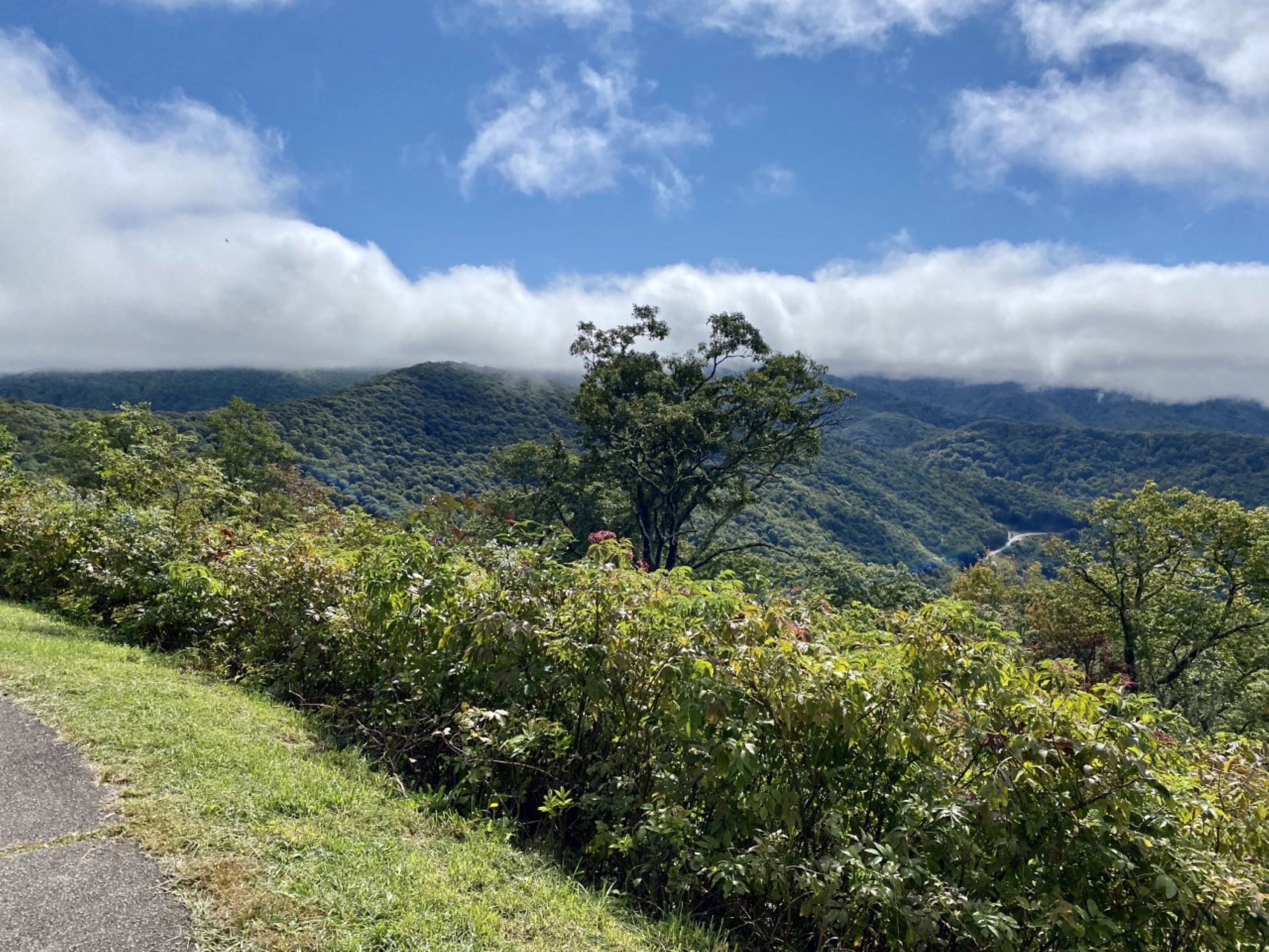
Looking south from Plott Balsam Overlook. Terrain and imagery at true elevation.

Plott Balsam Overlook sits at 5,020 feet on the Blue Ridge Parkway, facing south, with the land dropping 685 feet within 600 meters of the pull-off. An informational sign at the site covers the history of the Plott family, including the development of the Plott Bear Hound, which the North Carolina General Assembly named the official State Dog in 1989. From the overlook, Soco Falls and its overlook are visible to the south-southeast at 1.1 miles, followed by Fed Cove Overlook and Thunderstruck Overlook to the southeast within about two miles. Farther out, the view extends to Hornbuckle Valley, Woolyback Overlook, and Cranberry Ridge Overlook, along with the peaks of Campbell Lick, Waterrock Knob, and Browning Knob, all within four miles to the east-southeast and southeast. Waynesville lies 10.5 miles east, with Asheville 35.6 miles east and Sevierville 33.1 miles northwest. Maggie Valley Overlook precedes this stop along the Parkway, and Lake Junaluska Overlook follows. Sunrise and sunset times vary by season, from a 06:18 sunrise at the June solstice to a 07:39 sunrise at the December solstice.

Access
On the byway
Elevation
5,020 ft
View
South · 180°
Relief
685 ft drop
In view
11 named features
View from Plott Balsam Overlook
NPS Photo / Tina Haver Currin · Public domain (NPS) · NPS
Bunche's Bald Tunnel on the Blue Ridge Mountain Parkway
Photographer:Doug Bradley · CC BY 2.0 · source
At the Soco Gap, located at the eastern point of the Qualla Boundary, between Haywood and Jackson counties, and connects both U.S. Route 19 and the Blue Ridge Parkway.
Washuotaku · CC BY-SA 4.0 · source
Blue Ridge Parkway Smoky Mt. NP
Pete Seabolt · CC BY 3.0 · source
15-19-013: bunches bald overlook
David Dugan · CC BY-SA 3.0 · source
15-19-010: bunches bald overlook
David Dugan · CC BY-SA 3.0 · source

What you’re looking at

Named terrain inside the view from this overlook, nearest first.

  • Soco Falls Overlook3,984 ftsouth-southeast · 1.1 mi
  • Soco Falls3,966 ftsouth-southeast · 1.1 mi
  • Fed Cove Overlook (MP 455.1)4,661 ftsoutheast · 1.8 mi
  • Thunderstruck Overlook (MP 454.4)4,864 ftsoutheast · 2.1 mi
  • Campbell Lick5,561 fteast-southeast · 2.4 mi
  • Hornbuckle Valley (MP 453.4)5,221 ftsoutheast · 2.7 mi
  • Woolyback Overlook (MP 452.3)5,584 ftsouth-southeast · 3.3 mi
  • Cranberry Ridge Overlook (MP 452.1)5,609 ftsouth-southeast · 3.4 mi
  • Waterrock Knob6,277 ftsoutheast · 3.7 mi
  • Pedestrian Overlook6,045 ftsouth-southeast · 3.7 mi
  • Browning Knob6,239 ftsoutheast · 3.9 mi

Light

DateSunriseSunsetGolden hour
March equinox07:3719:4519:11
June solstice06:1820:5220:14
September equinox07:2119:3118:58
December solstice07:3917:2416:45

Local time (America/New_York). Computed for this exact position.

Where it is

  • Waynesville10.5 mi east
  • Sevierville33.1 mi northwest
  • Asheville35.6 mi east
Loading map…
Private beta · Free to join

Take the scenic way to Plott Balsam Overlook.

Byway plans around your taste, verified places, real weather and opening hours — then opens every leg in Google Maps with one tap.

Private beta · Free to join · No card · Invite when a spot opens

Plott Balsam Overlook · National Park Service

The Blue Ridge Parkway travels the spine of some of the highest mountains in the Plott Balsam Range, which were named for the Plott family. Plott Balsam Overlook has an informational sign that explores some of this family history, including the creation of their famed hunting dogs, the Plott Bear Hounds. In 1989, the North Carolina General Assembly honored the Plott Hound with the designation of official State Dog. At 5,020 feet, Plott Balsam Overlook offers sweeping views of this protected landscape, which includes a variety of habitats like Appalachian spruce-fir forests, northern hardwood forests, rock outcroppings, and high-elevation bogs. The extensive Plott Balsam Range stretches southwest from the Tuckasegee River Valley in Sylva, NC to Maggie Valley, NC in the northeast. This range is often overlooked due to being flanked by the taller Great Smoky Mountains to the north and the Great Balsams to the south. But seasoned Parkway visitors know that some of the best views can be seen from the Plott Balsams. Waterrock Knob (6,292 feet) is the highest peak in the Plott Balsam Range, while Waterrock Knob Visitor Center, at 5,820 feet, is the highest-elevation center along the Parkway. Check the conditions of the area before you visit.

Read it at National Park Service

Waterrock Knob · WikipediaCC BY-SA

Waterrock Knob is a mountain peak in the U.S. state of North Carolina. It is the highest peak in the Plott Balsams and is the 16th-highest mountain in the Eastern United States.

Read it at Wikipedia

How high is Plott Balsam Overlook?

Plott Balsam Overlook sits at about 5,020 feet (1,530 m).

What can you see from Plott Balsam Overlook?

From Plott Balsam Overlook: Soco Falls Overlook (SSE, 1.1 mi); Soco Falls (SSE, 1.1 mi); Fed Cove Overlook (MP 455.1) (SE, 1.8 mi); Thunderstruck Overlook (MP 454.4) (SE, 2.1 mi).

What is the nearest town to Plott Balsam Overlook?

Waynesville, 11 miles E of Plott Balsam Overlook.

What is the next lookout after Plott Balsam Overlook?

Lake Junaluska Overlook is the next surfaced lookout along the same route after Plott Balsam Overlook.

Drive to Plott Balsam Overlook with Byway

Byway plans the scenic way there — real places along Blue Ridge Parkway, real weather, zero hallucinations — and hands the turns to the navigation you already use.

Byways with this lookout

Locals make it Verified.

Plott Balsam Overlook — confirmed, rated, and photographed by people who actually pulled over. A local confirmation is what upgrades a lookout from Discovered to Verified. Zero hallucinations.

Confirmed by locals

No local confirmations yet. Stood here? Yours is the one that upgrades this lookout to Verified.

Ratings

No ratings yet. Stood at this lookout? Be the first to rate it.

No written reviews yet.

Field notes

No field notes yet. Know the gate hours or the best pull-in? Leave the note you wish you'd had.

Photos

No photos yet.

Sign in to confirm this lookout, rate it, add photos, and leave field notes.

More lookouts on Blue Ridge Parkway

Named places near this lookout