Skip to content

Point Park Tour Stop #2 - Parrott Gun Overlook

National Park Service
Looking east from Point Park Tour Stop #2 - Parrott Gun Overlook. Terrain and imagery at true elevation.

Point Park Tour Stop #2 sits at 2,099 feet on Lookout Mountain Parkway, facing east with the terrain dropping 844 feet within 600 meters of the overlook. The view faces toward sunrise, with land features spread across the east-northeast to south-southeast arc, most within one to three miles. Nearby points include John C. Wilson Memorial Park at 0.8 miles east-northeast, Roy Nelms Park at the same distance to the east-southeast, and St. Elmo Park 1.3 miles to the south-southeast. Farther out, Fort Negley Park, Main Terrain, and Shelia M Jennings Westside Park lie to the northeast and north-northeast between 2.6 and 2.8 miles. Chattanooga is 3.1 miles to the northeast. In late September 1863, members of Confederate Lt. Colonel Edward Porter Alexander's Artillery Battalion scaled these heights and watched the besieged US army from the summit; though too far to reach Chattanooga itself, their cannon reached Moccasin Bend and the Tennessee River, which they shelled daily. This stop follows Sunset Rock on the tour and precedes the Western Overlook & Wauhatchie stop.

Access
0.3 mi detour
Elevation
2,099 ft
View
East · 90°
Light
Best at sunrise
Relief
844 ft drop
In view
12 named features
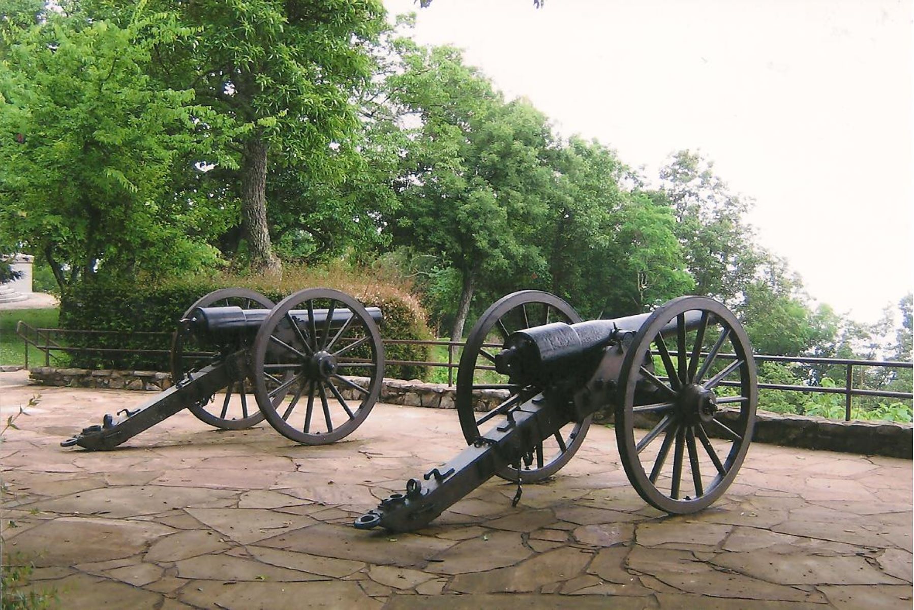
20-Pounder Parrott Cannon
Waymarking.com · Public domain (NPS) · NPS
Lookout Mountain, Tennessee, right outside of Point Park.
Thomsonmg2000 · CC0 · source
Western Civil War Battlefield, Tennessee, digital copy of slide. Complete indexed photo collection at WorldHistoryPics.com.
Gary Todd from Xinzheng, China · CC0 · source
Amy Todd (wife) and Zachary Todd (son). Western Civil War Battlefield, Tennessee. Complete indexed photo collection at WorldHistoryPics.com.
Gary Todd from Xinzheng, China · CC0 · source
Western Civil War Battlefield, Tennessee. Complete indexed photo collection at WorldHistoryPics.com.
Gary Todd from Xinzheng, China · CC0 · source
Western Civil War Battlefield, Tennessee. Complete indexed photo collection at WorldHistoryPics.com.
Gary Todd from Xinzheng, China · CC0 · source

What you’re looking at

Named terrain inside the view from this overlook, nearest first.

  • John C. Wilson Memorial Park840 fteast-northeast · 0.8 mi
  • Roy Nelms Park776 fteast-southeast · 0.8 mi
  • Tennessee Riverpark Wheland Foundry Trailhead666 fteast-northeast · 1.3 mi
  • St. Elmo Park723 ftsouth-southeast · 1.3 mi
  • Milliken Park681 fteast-southeast · 1.8 mi
  • Harris Johnson Park670 fteast-northeast · 2.0 mi
  • Pringle Park667 fteast-northeast · 2.0 mi
  • Piney Woods670 ftsoutheast · 2.4 mi
  • Fort Negley Park677 ftnortheast · 2.6 mi
  • Main Terrain671 ftnortheast · 2.7 mi
  • Caruthers Park662 fteast · 2.7 mi
  • Shelia M Jennings Westside Park697 ftnorth-northeast · 2.8 mi

Light

This overlook faces sunrise 0° off square to it.

DateSunriseSunsetGolden hour
March equinox07:4619:5319:20
June solstice06:2920:5920:22
September equinox07:3019:4019:06
December solstice07:4617:3416:55

Local time (America/New_York). Computed for this exact position.

Where it is

  • Chattanooga3.1 mi northeast
  • Dalton26.9 mi southeast
  • Cleveland28.3 mi east-northeast
Loading map…
Private beta · Free to join

Take the scenic way to Point Park Tour Stop #2 - Parrott Gun Overlook.

Byway plans around your taste, verified places, real weather and opening hours — then opens every leg in Google Maps with one tap.

Private beta · Free to join · No card · Invite when a spot opens

Point Park Tour Stop #2 - Parrott Gun Overlook · National Park Service

In late September 1863, members of Confederate Lt. Colonel Edward Porter Alexander's Artillery Battalion scaled the heights of Lookout Mountain. From the summit, they were able to watch the besieged US army. Although too far to reach Chattanooga, the cannon were able to pound away at Moccasin Bend and the Tennessee River on a daily basis.

Read it at National Park Service

How high is Point Park Tour Stop #2 - Parrott Gun Overlook?

Point Park Tour Stop #2 - Parrott Gun Overlook sits at about 2,099 feet (640 m).

What can you see from Point Park Tour Stop #2 - Parrott Gun Overlook?

From Point Park Tour Stop #2 - Parrott Gun Overlook: John C. Wilson Memorial Park (ENE, 0.8 mi); Roy Nelms Park (ESE, 0.8 mi); Tennessee Riverpark Wheland Foundry Trailhead (ENE, 1.3 mi); St. Elmo Park (SSE, 1.3 mi).

Is Point Park Tour Stop #2 - Parrott Gun Overlook better at sunrise or sunset?

Sunrise. The land falls away from Point Park Tour Stop #2 - Parrott Gun Overlook toward the sunrise, so at sunset the light is behind you. Exact times shift through the year; the page shows the current window.

What is the nearest town to Point Park Tour Stop #2 - Parrott Gun Overlook?

Chattanooga, 3.1 miles NE of Point Park Tour Stop #2 - Parrott Gun Overlook.

What is the next lookout after Point Park Tour Stop #2 - Parrott Gun Overlook?

Point Park Tour Stop #4 - Western Overlook & Wauhatchie is the next surfaced lookout along the same route after Point Park Tour Stop #2 - Parrott Gun Overlook.

Drive to Point Park Tour Stop #2 - Parrott Gun Overlook with Byway

Byway plans the scenic way there — real places along Lookout Mountain Parkway, real weather, zero hallucinations — and hands the turns to the navigation you already use.

Byways with this lookout

Day trips start here

Locals make it Verified.

Point Park Tour Stop #2 - Parrott Gun Overlook — confirmed, rated, and photographed by people who actually pulled over. A local confirmation is what upgrades a lookout from Discovered to Verified. Zero hallucinations.

Confirmed by locals

No local confirmations yet. Stood here? Yours is the one that upgrades this lookout to Verified.

Ratings

No ratings yet. Stood at this lookout? Be the first to rate it.

No written reviews yet.

Field notes

No field notes yet. Know the gate hours or the best pull-in? Leave the note you wish you'd had.

Photos

No photos yet.

Sign in to confirm this lookout, rate it, add photos, and leave field notes.

More lookouts on Lookout Mountain Parkway

Named places near this lookout