Skip to content

The Loops Overlook

VerifiedOpenStreetMap + National Park Service
Looking south-east from The Loops Overlook. Terrain and imagery at true elevation.

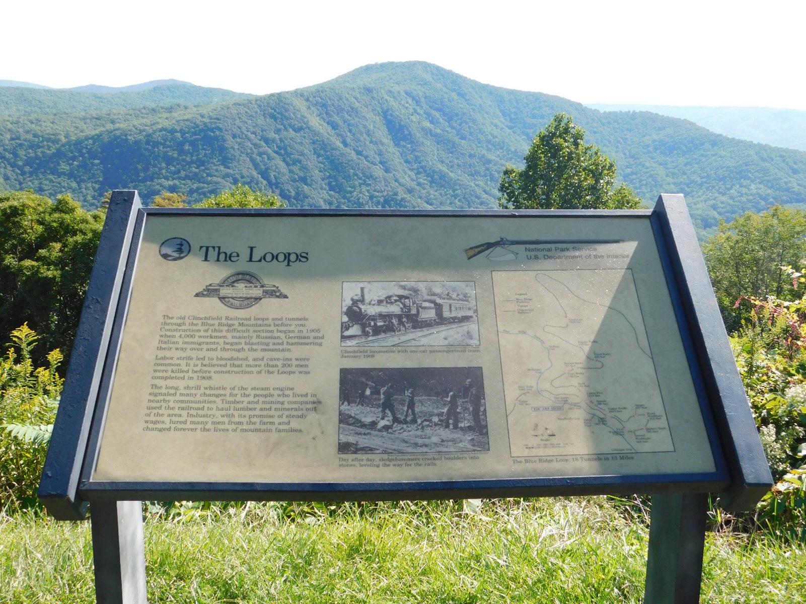
The Loops Overlook sits at 2,975 feet on the Blue Ridge Parkway, facing 120 degrees toward the northeast and east, with terrain dropping 500 feet within 600 meters of the edge. From this vantage, railroad enthusiasts watch trains ascending "The Loops," an engineered rail line built between 1905 and 1908 to link the coalfields of Kentucky with the cotton mills of the Carolina Piedmont. The line runs 13.5 miles and contains 18 tunnels along with numerous switchback curves, which give the feature its name; the trains are most visible after autumn leaf fall. The Historic Orchard at Altapass, established by the Clinchfield Railroad in 1908 and still in operation, lies directly below the overlook. Peaks visible from the site include Jackson Knob to the east at 1.7 miles, Honeycutt Mountain to the east-northeast at 4.0 miles, Dobson Knob to the south-southeast at 5.1 miles, and Dogback Mountain to the east at 6.3 miles. Because the overlook faces toward sunrise, it is suited to watching morning light and, after nightfall, observing the eastern sky. The nearest towns are Boone, 30.5 miles northeast; Asheville, 35.2 miles west-southwest; and Johnson City, 35.6 miles north-northwest. Table Rock Overlook lies before it on the route, with North Cove Overlook next.

Access
On the byway
Elevation
2,975 ft
View
Southeast · 120°
Light
Best at sunrise
Relief
500 ft drop
In view
4 named features
Wayside at The Loops Overlook
NPS Photo · Public domain (NPS) · NPS
The terraced hillside of an apple orchard on the Blue Ridge Parkway near Altapass. Photo taken with a Panasonic Lumix DMC-FZ50 in McDowell County, NC, USA . Cropping and post-processing performed with The GIMP .
Ken Thomas · Public domain · source

What you’re looking at

Named terrain inside the view from this overlook, nearest first.

  • Jackson Knob3,404 fteast · 1.7 mi
  • Honeycutt Mountain3,623 fteast-northeast · 4.0 mi
  • Dobson Knob3,690 ftsouth-southeast · 5.1 mi
  • Dogback Mountain3,519 fteast · 6.3 mi

Light

This overlook faces sunrise 30° off square to it.

DateSunriseSunsetGolden hour
March equinox07:3319:4019:06
June solstice06:1320:4820:10
September equinox07:1719:2718:53
December solstice07:3517:1916:39

Local time (America/New_York). Computed for this exact position.

Where it is

  • Boone30.5 mi northeast
  • Asheville35.2 mi west-southwest
  • Johnson City35.6 mi north-northwest
Loading map…
Private beta · Free to join

Take the scenic way to The Loops Overlook.

Byway plans around your taste, verified places, real weather and opening hours — then opens every leg in Google Maps with one tap.

Private beta · Free to join · No card · Invite when a spot opens

The Loops Overlook · National Park Service

Railroad enthusiasts prize The Loops Overlook because it provides views of the trains ascending the Blue Ridge mountains from the valley below. The engineering marvel known as “The Loops” was constructed between 1905 and 1908 with the original intention of connecting the coalfields of Kentucky with the cotton mills of the Carolina Piedmont. It is 13.5 miles long, and contains 18 tunnels and many switchback curves -- giving “The Loops” its name. The trains are best viewed after the leaves fall from the trees. The Overlook provides views to the north, northeast, east and southeast. To the north, lies McKinney Gap named for Charles McKinney (1780-1852) through which the North Toe River Valley can be viewed. To the east, lie Jackson Knob and the Peppers Creek Valley. To the southeast, lie the Linville Ridge, Dobson Knob and Bald Knob.  Due to its eastward facing orientation, the Loops Overlook is an excellent place to watch the sunrise and is generally dark enough after nightfall to observe any astronomical phenomenon that occur in that portion of the sky. The Loops is also a prime location to witness the natural phenomenon known as a fogfall.  When atmospheric conditions are right, fog forms in the North Toe River Valley, travels through McKinney Gap and because the fog is heavier than the surrounding air cascades down the slopes into the valley below.  This river of fog plunging through the gap and down the steep mountainside can rival the views of the parkway's most beautiful waterfalls.  The fogfall phenomenon occurs most frequently in the mornings from Mid-August to Early October.  The Loops Overlook provides views of the Historic Orchard at Altapass lying directly below the overlook. The Historic Orchard at Altapass has been in operation for well over a century and was originally created by the Clinchfield Railroad in 1908. Check the conditions of the area before you visit.

Read it at National Park Service

How high is The Loops Overlook?

The Loops Overlook sits at about 2,975 feet (907 m).

What can you see from The Loops Overlook?

From The Loops Overlook: Jackson Knob (E, 1.7 mi); Honeycutt Mountain (ENE, 4.0 mi); Dobson Knob (SSE, 5.1 mi); Dogback Mountain (E, 6.3 mi).

Is The Loops Overlook better at sunrise or sunset?

Sunrise. The land falls away from The Loops Overlook toward the sunrise, so at sunset the light is behind you. Exact times shift through the year; the page shows the current window.

What is the nearest town to The Loops Overlook?

Boone, 31 miles NE of The Loops Overlook.

What is the next lookout after The Loops Overlook?

North Cove Overlook is the next surfaced lookout along the same route after The Loops Overlook.

Drive to The Loops Overlook with Byway

Byway plans the scenic way there — real places along Blue Ridge Parkway, real weather, zero hallucinations — and hands the turns to the navigation you already use.

Byways with this lookout

Locals make it Verified.

The Loops Overlook — confirmed, rated, and photographed by people who actually pulled over. A local confirmation is what upgrades a lookout from Discovered to Verified. Zero hallucinations.

Confirmed by locals

No local confirmations yet. Stood here? Yours is the one that upgrades this lookout to Verified.

Ratings

No ratings yet. Stood at this lookout? Be the first to rate it.

No written reviews yet.

Field notes

No field notes yet. Know the gate hours or the best pull-in? Leave the note you wish you'd had.

Photos

No photos yet.

Sign in to confirm this lookout, rate it, add photos, and leave field notes.

More lookouts on Blue Ridge Parkway

Named places near this lookout